TopoQuest Logo
Do you find TopoQuest useful?
Help keep TopoQuest running and adding new maps/features by donating!
Bitcoin:  19c7KJd3qBynnjoSw5npx9KScwjBe4ifkT
Litecoin:  LXs6TkuXGGXo1vDsWCkWVdjQX94eUKd6ui
Home View Maps Find Maps Find Places Resources & Links


Squaw Peak, New Mexico Topographic Map

USGS Map Title: Squaw Peak, NM
USGS Map MRC: 33107H3
DRG (GeoTIFF) Download: o33107h3.tif


Neighboring USGS Topographic Map Quads:


  Tres Montosas, NM  
34107A4
 

  Arroyo Landavaso, NM  
34107A3
 

  Magdalena, NM  
34107A2
 

  Mount Withington, NM  
33107H4
 

  Squaw Peak, NM  
33107H3
 

  South Baldy, NM  
33107H2
 

  Grassy Lookout, NM  
33107G4
 

  Tenmile Hill, NM  
33107G3
 

  Puertecito Gap, NM  
33107G2


Map MRC Location:

N34°
W108°
N34°
W107°
H8 H7 H6 H5 H4 H3 H2 H1
G8 G7 G6 G5 G4 G3 G2 G1
F8 F7 F6 F5 F4 F3 F2 F1
E8 E7 E6 E5 E4 E3 E2 E1
D8 D7 D6 D5 D4 D3 D2 D1
C8 C7 C6 C5 C4 C3 C2 C1
B8 B7 B6 B5 B4 B3 B2 B1
A8 A7 A6 A5 A4 A3 A2 A1
N33°
W108°
N33°
W107°

Squaw Peak, NM USGS 1:24K Topographic Map Preview:
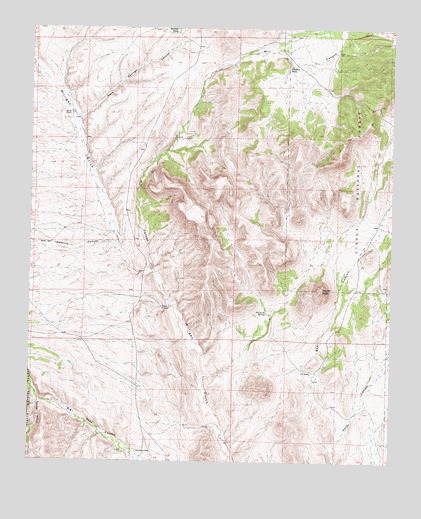
Squaw Peak, NM USGS Topographic Map
Click on map above to begin viewing in our Map Viewer.

This topographic map contains these locations and features:
Feature Name Type Latitude Longitude GNIS ID View Map
Alameda SpringSpringN33.9182°W107.2939°903034View Map
Barnet TankReservoirN33.9896°W107.3058°903571View Map
Bear CanyonValleyN33.8767°W107.2703°903639View Map
Chavez CanyonValleyN33.8928°W107.3714°905051View Map
Chocle WindmillLocaleN33.9195°W107.3300°905121View Map
Estaline CanyonValleyN33.9376°W107.3448°906198View Map
Gap WellWellN33.9073°W107.2523°913676View Map
Garcia RanchLocaleN33.9659°W107.3270°906478View Map
McDaniel TankReservoirN33.9893°W107.2859°908509View Map
Mill CanyonValleyN33.9295°W107.3328°908741View Map
Old Garcia RanchLocaleN33.9751°W107.3617°909339View Map
Rancho La RosaLocaleN33.8776°W107.3375°910003View Map
Rock Header TankReservoirN33.9549°W107.2684°913675View Map
Rock Springs CanyonValleyN33.9681°W107.3584°910385View Map
S O RanchLocaleN33.9009°W107.2775°910495View Map
Squaw PeakSummitN33.9248°W107.2745°911373View Map
Stallings TankReservoirN33.9998°W107.3253°902922View Map

Note: Coordinates in the location and feature list above are referenced to NAD83 datum.


Copyright (C) 2008-2024 Ryan Niemi / Sunset Dynamics ... All Rights Reserved