TopoQuest Logo
Do you find TopoQuest useful?
Help keep TopoQuest running and adding new maps/features by donating!
Bitcoin:  19c7KJd3qBynnjoSw5npx9KScwjBe4ifkT
Litecoin:  LXs6TkuXGGXo1vDsWCkWVdjQX94eUKd6ui
Home View Maps Find Maps Find Places Resources & Links


Arroyo Landavaso, New Mexico Topographic Map

USGS Map Title: Arroyo Landavaso, NM
USGS Map MRC: 34107A3
DRG (GeoTIFF) Download: o34107a3.tif


Neighboring USGS Topographic Map Quads:


  Gallinas Peak, NM  
34107B4
 

  Silver Hill, NM  
34107B3
 

  Granite Mountain, NM  
34107B2
 

  Tres Montosas, NM  
34107A4
 

  Arroyo Landavaso, NM  
34107A3
 

  Magdalena, NM  
34107A2
 

  Mount Withington, NM  
33107H4
 

  Squaw Peak, NM  
33107H3
 

  South Baldy, NM  
33107H2


Map MRC Location:

N35°
W108°
N35°
W107°
H8 H7 H6 H5 H4 H3 H2 H1
G8 G7 G6 G5 G4 G3 G2 G1
F8 F7 F6 F5 F4 F3 F2 F1
E8 E7 E6 E5 E4 E3 E2 E1
D8 D7 D6 D5 D4 D3 D2 D1
C8 C7 C6 C5 C4 C3 C2 C1
B8 B7 B6 B5 B4 B3 B2 B1
A8 A7 A6 A5 A4 A3 A2 A1
N34°
W108°
N34°
W107°

Arroyo Landavaso, NM USGS 1:24K Topographic Map Preview:
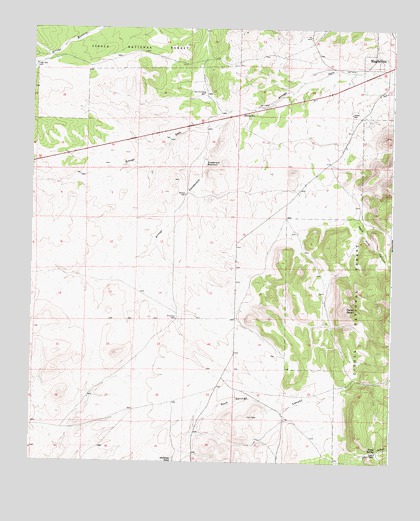
Arroyo Landavaso, NM USGS Topographic Map
Click on map above to begin viewing in our Map Viewer.

This topographic map contains these locations and features:
Feature Name Type Latitude Longitude GNIS ID View Map
Agua Frio CanyonValleyN34.0709°W107.2636°903012View Map
Arroyo LandavasoArroyoN34.0990°W107.3089°903393View Map
Boxcar WellWellN34.0770°W107.3214°904047View Map
Cerro PelonSummitN34.0445°W107.2656°904988View Map
Deer Water WellWellN34.0187°W107.3550°925790View Map
Driveway WellWellN34.0412°W107.3245°905863View Map
Earth Tank Number OneReservoirN34.0528°W107.2646°913934View Map
Earth Tank Number TwoReservoirN34.0385°W107.2783°913928View Map
Easy TankReservoirN34.0177°W107.3036°913919View Map
Gosey WellWellN34.1006°W107.2645°906665View Map
Hale Driveway WellWellN34.1065°W107.3153°906809View Map
Hale TankReservoirN34.1152°W107.3158°937080View Map
High WellWellN34.1145°W107.3742°906976View Map
Landavaso ReservoirReservoirN34.0865°W107.3155°907840View Map
Magdalena AirportAirportN34.0887°W107.3011°936982View Map
Magdalena DivisionCivilN34.0723°W107.3316°1937555View Map
North TankReservoirN34.0782°W107.2601°913931View Map
Number Five TankReservoirN34.0602°W107.2797°913920View Map
Number Four TankReservoirN34.0545°W107.2734°913933View Map
Number One TankReservoirN34.0326°W107.2673°913929View Map
Number Three TankReservoirN34.0515°W107.2686°913925View Map
Number Two TankReservoirN34.0428°W107.2723°913926View Map
Palome TankReservoirN34.0399°W107.2640°913927View Map
Rabbe WellWellN34.1001°W107.3017°909948View Map
Rancho Magdalena AirportAirportN34.1001°W107.2957°2444036View Map
RG 30788 Water WellWellN34.0653°W107.2584°925776View Map
SW Hale TankReservoirN34.1149°W107.3322°900266View Map
Texas SpringSpringN34.0041°W107.2542°911622View Map
Texas WellWellN34.0031°W107.2548°911623View Map
Wet Weather SpringSpringN34.0242°W107.2523°913930View Map
Woodbury RanchLocaleN34.0662°W107.2598°913932View Map

Note: Coordinates in the location and feature list above are referenced to NAD83 datum.


Copyright (C) 2008-2024 Ryan Niemi / Sunset Dynamics ... All Rights Reserved