TopoQuest Logo
Do you find TopoQuest useful?
Help keep TopoQuest running and adding new maps/features by donating!
Bitcoin:  19c7KJd3qBynnjoSw5npx9KScwjBe4ifkT
Litecoin:  LXs6TkuXGGXo1vDsWCkWVdjQX94eUKd6ui
Home View Maps Find Maps Find Places Resources & Links


Spring Lake, Florida Topographic Map

USGS Map Title: Spring Lake, FL
USGS Map MRC: 28082D3
DRG (GeoTIFF) Download: o28082d3.tif


Neighboring USGS Topographic Map Quads:


  Brooksville, FL  
28082E4
 

  Brooksville SE, FL  
28082E3
 

  Saint Catherine, FL  
28082E2
 

  Masaryktown, FL  
28082D4
 

  Spring Lake, FL  
28082D3
 

  Lacoochee, FL  
28082D2
 

  Ehren, FL  
28082C4
 

  San Antonio, FL  
28082C3
 

  Dade City, FL  
28082C2


Map MRC Location:

N29°
W83°
N29°
W82°
H8 H7 H6 H5 H4 H3 H2 H1
G8 G7 G6 G5 G4 G3 G2 G1
F8 F7 F6 F5 F4 F3 F2 F1
E8 E7 E6 E5 E4 E3 E2 E1
D8 D7 D6 D5 D4 D3 D2 D1
C8 C7 C6 C5 C4 C3 C2 C1
B8 B7 B6 B5 B4 B3 B2 B1
A8 A7 A6 A5 A4 A3 A2 A1
N28°
W83°
N28°
W82°

Spring Lake, FL USGS 1:24K Topographic Map Preview:
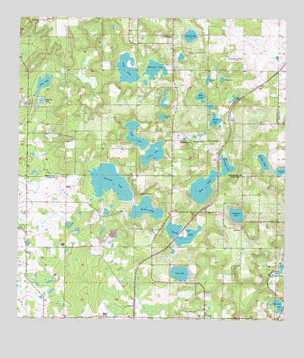
Spring Lake, FL USGS Topographic Map
Click on map above to begin viewing in our Map Viewer.

This topographic map contains these locations and features:
Feature Name Type Latitude Longitude GNIS ID View Map
Bay Spring SchoolSchoolN28.4492°W82.2926°278228View Map
Charlotte PondLakeN28.4592°W82.3081°280329View Map
Chukuchatta (historical)Populated PlaceN28.4003°W82.2998°294509View Map
DixiePopulated PlaceN28.4350°W82.3026°281601View Map
Dollar PondLakeN28.3940°W82.2546°281665View Map
Flag PondLakeN28.4407°W82.2601°282536View Map
Gold LakeSwampN28.4729°W82.3634°283144View Map
Hancock LakeLakeN28.4320°W82.3317°283680View Map
Harrison LakeLakeN28.3817°W82.2525°283772View Map
Hickory HillSummitN28.4833°W82.2737°283959View Map
JessaminePopulated PlaceN28.4136°W82.2701°294817View Map
Jessamine LakeLakeN28.4190°W82.2723°284775View Map
Johnson CemeteryCemeteryN28.4517°W82.3567°284864View Map
Lake IolaLakeN28.3945°W82.2986°284584View Map
Long PondLakeN28.4639°W82.2856°286047View Map
McClendon LakeLakeN28.4386°W82.2770°286577View Map
Middle LakeLakeN28.4208°W82.3147°286804View Map
Moody LakeLakeN28.4100°W82.2951°287084View Map
Mount Pleasant ChurchChurchN28.4489°W82.2940°287294View Map
Mountain LakeLakeN28.4792°W82.3112°287371View Map
Mud LakeLakeN28.4314°W82.2876°287406View Map
Neff Fish CampLocaleN28.4800°W82.3204°300941View Map
Neff LakeLakeN28.4789°W82.3243°287571View Map
Nicks LakeLakeN28.4490°W82.3187°287733View Map
Pasco County Fire Rescue Station 33BuildingN28.4098°W82.3330°2131549View Map
Patsy PondLakeN28.4748°W82.2796°288574View Map
Robison LakeLakeN28.4575°W82.2831°289802View Map
Saint Clair LakeLakeN28.4448°W82.3111°290164View Map
Saint JosephPopulated PlaceN28.3758°W82.2868°290243View Map
Sea PondLakeN28.4677°W82.2739°290780View Map
Simmon PondLakeN28.4741°W82.2866°291145View Map
Sparkman LakeLakeN28.4653°W82.3644°291483View Map
Spring LakeLakeN28.4931°W82.2948°291547View Map
Spring LakePopulated PlaceN28.4936°W82.3029°291557View Map
Spring Lake Census Designated PlaceCensusN28.4952°W82.3017°2402889View Map
Spring Lake United Methodist ChurchChurchN28.4931°W82.3033°2105465View Map
Townsend House CemeteryCemeteryN28.4275°W82.3184°292388View Map
Twin Lakes CemeteryCemeteryN28.4417°W82.2973°292615View Map
Zuke PondLakeN28.4684°W82.2897°294346View Map

Note: Coordinates in the location and feature list above are referenced to NAD83 datum.


Copyright (C) 2008-2024 Ryan Niemi / Sunset Dynamics ... All Rights Reserved