TopoQuest Logo
Do you find TopoQuest useful?
Help keep TopoQuest running and adding new maps/features by donating!
Bitcoin:  19c7KJd3qBynnjoSw5npx9KScwjBe4ifkT
Litecoin:  LXs6TkuXGGXo1vDsWCkWVdjQX94eUKd6ui
Home View Maps Find Maps Find Places Resources & Links


South Mountain, Vermont Topographic Map

USGS Map Title: South Mountain, VT
USGS Map MRC: 44073A1
DRG (GeoTIFF) Download: o44073a1.tif


Neighboring USGS Topographic Map Quads:


  Vergennes East, VT  
44073B2
 

  Bristol, VT  
44073B1
 

  Mount Ellen, VT  
44072B8
 

  Middlebury, VT  
44073A2
 

  South Mountain, VT  
44073A1
 

  Lincoln, VT  
44072A8
 

  Cornwall, VT  
43073H2
 

  East Middlebury, VT  
43073H1
 

  Bread Loaf, VT  
43072H8


Map MRC Location:

N45°
W74°
N45°
W73°
H8 H7 H6 H5 H4 H3 H2 H1
G8 G7 G6 G5 G4 G3 G2 G1
F8 F7 F6 F5 F4 F3 F2 F1
E8 E7 E6 E5 E4 E3 E2 E1
D8 D7 D6 D5 D4 D3 D2 D1
C8 C7 C6 C5 C4 C3 C2 C1
B8 B7 B6 B5 B4 B3 B2 B1
A8 A7 A6 A5 A4 A3 A2 A1
N44°
W74°
N44°
W73°

South Mountain, VT USGS 1:24K Topographic Map Preview:
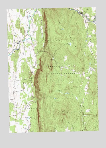
South Mountain, VT USGS Topographic Map
Click on map above to begin viewing in our Map Viewer.

This topographic map contains these locations and features:
Feature Name Type Latitude Longitude GNIS ID View Map
Abbey PondLakeN44.0333°W73.0598°1460511View Map
Abbey Pond TrailTrailN44.0345°W73.0768°1460512View Map
Alder BrookStreamN44.0153°W73.0204°1460521View Map
Beaver MeadowSwampN44.0409°W73.0521°1460584View Map
Beaver Meadow BrookStreamN44.1103°W73.0035°1460587View Map
Beaver Meadow TrailTrailN44.0548°W73.0501°1460588View Map
Bristol Cliffs WildernessReserveN44.1037°W73.0496°1461751View Map
Bristol FlatsFlatN44.1153°W73.0946°1460662View Map
Case Street CemeteryCemeteryN44.0267°W73.0990°1460707View Map
Cushman CemeteryCemeteryN44.0065°W73.0381°1918077View Map
Dow PondReservoirN44.0148°W73.0976°1460805View Map
Dow Pond DamDamN44.0142°W73.0976°1766667View Map
Elephant Mountain Camping AreaLocaleN44.0739°W73.0840°1918091View Map
Gilmore PondLakeN44.0883°W73.0368°1460903View Map
Higgins PondReservoirN44.0968°W73.0657°1918120View Map
Isham BrookStreamN44.1176°W73.0176°1461017View Map
Maple CemeteryCemeteryN44.1101°W73.0008°1461122View Map
Middleblury Municipal ForestForestN44.0681°W73.0715°1918164View Map
Middlebury Water SupplyReservoirN44.0734°W73.0607°1461150View Map
Middlebury WaterworksLocaleN44.0034°W73.0996°1461800View Map
Munger Street CemeteryCemeteryN44.0560°W73.1146°1461195View Map
New Haven MillsPopulated PlaceN44.0917°W73.1087°1461206View Map
North PondLakeN44.1036°W73.0469°1461232View Map
Quarry Hill SchoolSchoolN44.0190°W73.1122°2427463View Map
Rathbun PitMineN44.0767°W73.0836°2709863View Map
Riverside CemeteryCemeteryN44.0844°W73.1119°1461334View Map
Robert Frost MountainSummitN44.0203°W73.0468°1460357View Map
Saint Therese CemeteryCemeteryN44.0251°W73.0231°1461369View Map
South MountainSummitN44.0995°W73.0493°1461440View Map
The CobbleSummitN44.0587°W73.0935°1461526View Map
Town of BristolCivilN44.1231°W73.0701°1462053View Map
Town of MiddleburyCivilN44.0043°W73.1224°1462146View Map
Union ChurchChurchN44.0926°W73.1090°1461558View Map
West LincolnPopulated PlaceN44.1189°W73.0201°1461594View Map

Note: Coordinates in the location and feature list above are referenced to NAD83 datum.


Copyright (C) 2008-2024 Ryan Niemi / Sunset Dynamics ... All Rights Reserved