TopoQuest Logo
Do you find TopoQuest useful?
Help keep TopoQuest running and adding new maps/features by donating!
Bitcoin:  19c7KJd3qBynnjoSw5npx9KScwjBe4ifkT
Litecoin:  LXs6TkuXGGXo1vDsWCkWVdjQX94eUKd6ui
Home View Maps Find Maps Find Places Resources & Links


Shell Lake, Wisconsin Topographic Map

USGS Map Title: Shell Lake, WI
USGS Map MRC: 45091F8
DRG (GeoTIFF) Download: o45091f8.tif


Neighboring USGS Topographic Map Quads:


  Poquettes Lake, WI  
45092G1
 

  Spooner, WI  
45091G8
 

  Spooner Lake, WI  
45091G7
 

  Timberland, WI  
45092F1
 

  Shell Lake, WI  
45091F8
 

  Sarona, WI  
45091F7
 

  Cumberland, WI  
45092E1
 

  Lower Vermillion Lake, WI  
45091E8
 

  Haugen, WI  
45091E7


Map MRC Location:

N46°
W92°
N46°
W91°
H8 H7 H6 H5 H4 H3 H2 H1
G8 G7 G6 G5 G4 G3 G2 G1
F8 F7 F6 F5 F4 F3 F2 F1
E8 E7 E6 E5 E4 E3 E2 E1
D8 D7 D6 D5 D4 D3 D2 D1
C8 C7 C6 C5 C4 C3 C2 C1
B8 B7 B6 B5 B4 B3 B2 B1
A8 A7 A6 A5 A4 A3 A2 A1
N45°
W92°
N45°
W91°

Shell Lake, WI USGS 1:24K Topographic Map Preview:
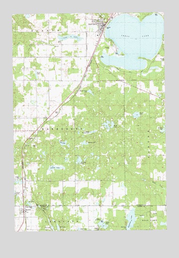
Shell Lake, WI USGS Topographic Map
Click on map above to begin viewing in our Map Viewer.

This topographic map contains these locations and features:
Feature Name Type Latitude Longitude GNIS ID View Map
Barron County ParkParkN45.6308°W91.9313°1837875View Map
BarronettPopulated PlaceN45.6369°W91.9930°1561205View Map
Barronett Census Designated PlaceCensusN45.6363°W91.9941°2586456View Map
Barronett TownhallBuildingN45.6902°W91.9752°1833824View Map
Brickyard SchoolSchoolN45.6563°W91.9952°1562193View Map
Butternut LakeLakeN45.6305°W91.9045°1562482View Map
City of Shell LakeCivilN45.7323°W91.9033°1584143View Map
Deep LakeLakeN45.6393°W91.9797°1563843View Map
Deer LakeLakeN45.6270°W91.9644°1563842View Map
Fox LakeLakeN45.6271°W91.9694°2558889View Map
Full Gospel ChurchChurchN45.7308°W91.9316°1833844View Map
Grassy LakeLakeN45.6613°W91.9668°1565776View Map
Heart LakeLakeN45.7149°W91.9807°1566249View Map
Heart Lake ChurchChurchN45.7119°W91.9810°1566250View Map
Indianhead Medical Center Shell LakeHospitalN45.7423°W91.9265°2698478View Map
Johnson LakeLakeN45.6752°W91.9417°1567235View Map
Kingdom Hall of Jehovahs WitnessesChurchN45.7313°W91.9316°1833848View Map
Lake Park Alliance ChurchChurchN45.7383°W91.9293°1833849View Map
Lakeside CemeteryCemeteryN45.6555°W91.9913°1567778View Map
Leaman LakeLakeN45.6654°W91.9463°1567917View Map
Little Grassy LakeLakeN45.6817°W91.9347°1568268View Map
Little Grassy Lake 3NW80814 DamDamN45.6816°W91.9318°1793643View Map
Long LakeLakeN45.7360°W91.9528°1568563View Map
Memorial ParkParkN45.7416°W91.9230°1833855View Map
Mill PondLakeN45.6410°W91.9883°1569488View Map
Museum of WoodcarvingBuildingN45.7480°W91.9191°1833856View Map
Pine LakeLakeN45.6258°W91.9472°2772043View Map
Pine LakeLakeN45.6756°W91.9596°1571497View Map
Round LakeLakeN45.6910°W91.8989°1572663View Map
Saint Johns German Lutheran Church (historical)ChurchN45.7399°W91.9257°1833864View Map
Saint Joseph Catholic ChurchChurchN45.7438°W91.9277°1833865View Map
Saint Stephens Episcopal ChurchChurchN45.7408°W91.9252°1833866View Map
Salem Lutheran ChurchChurchN45.7463°W91.9274°1833867View Map
Scout IslandIslandN45.7263°W91.9110°1573851View Map
Shell LakeLakeN45.7340°W91.8996°1574006View Map
Shell LakePopulated PlaceN45.7394°W91.9255°1574007View Map
Shell Lake City HallBuildingN45.7427°W91.9271°1833870View Map
Shell Lake Elementary SchoolSchoolN45.7299°W91.9367°1833871View Map
Shell Lake Fire DepartmentBuildingN45.7437°W91.9310°2696891View Map
Shell Lake High SchoolSchoolN45.7463°W91.9252°1833872View Map
Shell Lake Industrial ParkLocaleN45.7341°W91.9271°1833873View Map
Shell Lake Junior / Senior High SchoolSchoolN45.7300°W91.9367°2713225View Map
Shell Lake Municipal AirportAirportN45.7302°W91.9170°1582204View Map
Shell Lake Municipal CampgroundLocaleN45.7413°W91.9232°1833874View Map
Shell Lake Police DepartmentBuildingN45.7433°W91.9259°2759640View Map
Shell Lake Primary SchoolSchoolN45.7299°W91.9369°2713224View Map
Shingle Camp LakeLakeN45.7047°W91.9365°1574050View Map
Spider LakeLakeN45.6276°W91.9278°1574541View Map
Town of BarronettCivilN45.6808°W91.9720°1582757View Map
Washburn County CourthouseBuildingN45.7419°W91.9249°1833889View Map
Washburn County Historical MuseumBuildingN45.7399°W91.9257°1833890View Map
Washburn County Sheriff's OfficeBuildingN45.7419°W91.9250°2759481View Map
WCSW-AM (Shell Lake)TowerN45.6933°W91.9660°1582572View Map
Welsh LakeLakeN45.6832°W91.9222°1576424View Map
WGMO-FM (Shell Lake)TowerN45.6738°W91.9788°1582629View Map
Wisconsin Indianhead Technical CollegeSchoolN45.7479°W91.9165°2713388View Map

Note: Coordinates in the location and feature list above are referenced to NAD83 datum.


Copyright (C) 2008-2024 Ryan Niemi / Sunset Dynamics ... All Rights Reserved