TopoQuest Logo
Do you find TopoQuest useful?
Help keep TopoQuest running and adding new maps/features by donating!
Bitcoin:  19c7KJd3qBynnjoSw5npx9KScwjBe4ifkT
Litecoin:  LXs6TkuXGGXo1vDsWCkWVdjQX94eUKd6ui
Home View Maps Find Maps Find Places Resources & Links


Sharon, South Carolina Topographic Map

USGS Map Title: Sharon, SC
USGS Map MRC: 34081H3
DRG (GeoTIFF) Download: o34081h3.tif


Neighboring USGS Topographic Map Quads:


  Kings Creek, SC  
35081A4
 

  Filbert, SC  
35081A3
 

  Clover, SC  
35081A2
 

  Hickory Grove, SC  
34081H4
 

  Sharon, SC  
34081H3
 

  Tirzah, SC  
34081H2
 

  Lockhart, SC  
34081G4
 

  Armenia, SC  
34081G3
 

  Lowrys, SC  
34081G2


Map MRC Location:

N35°
W82°
N35°
W81°
H8 H7 H6 H5 H4 H3 H2 H1
G8 G7 G6 G5 G4 G3 G2 G1
F8 F7 F6 F5 F4 F3 F2 F1
E8 E7 E6 E5 E4 E3 E2 E1
D8 D7 D6 D5 D4 D3 D2 D1
C8 C7 C6 C5 C4 C3 C2 C1
B8 B7 B6 B5 B4 B3 B2 B1
A8 A7 A6 A5 A4 A3 A2 A1
N34°
W82°
N34°
W81°

Sharon, SC USGS 1:24K Topographic Map Preview:
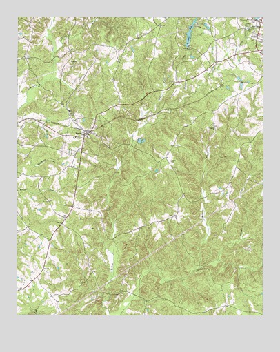
Sharon, SC USGS Topographic Map
Click on map above to begin viewing in our Map Viewer.

This topographic map contains these locations and features:
Feature Name Type Latitude Longitude GNIS ID View Map
BlairsvillePopulated PlaceN34.9154°W81.3504°1233609View Map
Buckhorn CreekStreamN34.9832°W81.3562°1221082View Map
Caldwell LakeReservoirN34.9938°W81.2870°1221196View Map
Calvary Church (historical)ChurchN34.8999°W81.3395°1233623View Map
Cuba School (historical)SchoolN34.9882°W81.2926°1233684View Map
Dry ForkStreamN34.9551°W81.3098°1222114View Map
Harmony Church (historical)ChurchN34.9474°W81.2954°1233750View Map
Hill Street Church of GodChurchN34.9862°W81.2501°1233758View Map
Hillcrest Baptist ChurchChurchN34.9721°W81.2948°1245992View Map
Hopewell School (historical)SchoolN34.9537°W81.2748°1237457View Map
Hopewell United Methodist ChurchChurchN34.9543°W81.2754°1246057View Map
Lindsey CreekStreamN34.8982°W81.2731°1246377View Map
Lower York ReservoirReservoirN34.9835°W81.2531°1240358View Map
Lower York Reservoir Dam D-1222DamN34.9835°W81.2531°1240357View Map
McClure CreekStreamN34.8951°W81.2617°1233794View Map
McClures BranchStreamN34.8949°W81.2826°1224392View Map
McConnells DivisionCivilN34.8769°W81.2515°1938343View Map
Mount Carmel Freewill Baptist ChurchChurchN34.9743°W81.3265°1249564View Map
Pine Bluff School (historical)SchoolN34.9151°W81.2934°1233846View Map
Pleasant Grove Presbyterian ChurchChurchN34.9168°W81.2956°1233854View Map
Rainey Town School (historical)SchoolN34.9146°W81.3515°1233861View Map
Ross BranchStreamN34.9679°W81.2870°1226034View Map
Saint John Baptist ChurchChurchN34.9604°W81.3481°1250561View Map
SharonPopulated PlaceN34.9510°W81.3409°1226537View Map
Sharon Associate Reformed Presbyterian ChurchChurchN34.9443°W81.3423°1233902View Map
Sharon Baptist ChurchChurchN34.9479°W81.3409°1233903View Map
Sharon Fire DepartmentBuildingN34.9515°W81.3398°2578299View Map
Sharon School (historical)SchoolN34.9607°W81.3487°1233906View Map
Sharon United Methodist ChurchChurchN34.9507°W81.3345°1233907View Map
Silver CreekStreamN34.9968°W81.3406°1226618View Map
South Carolina Noname 46004 D-1230 DamDamN34.9882°W81.2881°1238537View Map
South Carolina Noname 46007 D-3677 DamDamN34.9601°W81.2548°1238542View Map
South Carolina Noname 46022 D-3643 DamDamN34.9935°W81.2831°1238563View Map
Sutton Spring (historical)Populated PlaceN34.9812°W81.2915°1248880View Map
Town of SharonCivilN34.9520°W81.3435°2407322View Map
Union CemeteryCemeteryN34.9907°W81.2542°1227285View Map
WBZK-AM (York)TowerN34.9974°W81.2523°1252431View Map
Wilsons ChapelChurchN34.9165°W81.3729°1233967View Map
Woodlawn Presbyterian ChurchChurchN34.9568°W81.3456°1251500View Map

Note: Coordinates in the location and feature list above are referenced to NAD83 datum.


Copyright (C) 2008-2024 Ryan Niemi / Sunset Dynamics ... All Rights Reserved