TopoQuest Logo
Do you find TopoQuest useful?
Help keep TopoQuest running and adding new maps/features by donating!
Bitcoin:  19c7KJd3qBynnjoSw5npx9KScwjBe4ifkT
Litecoin:  LXs6TkuXGGXo1vDsWCkWVdjQX94eUKd6ui
Home View Maps Find Maps Find Places Resources & Links


Kings Creek, South Carolina Topographic Map

USGS Map Title: Kings Creek, SC
USGS Map MRC: 35081A4
DRG (GeoTIFF) Download: o35081a4.tif


Neighboring USGS Topographic Map Quads:


  Blacksburg North, SC  
35081B5
 

  Grover, NC  
35081B4
 

  Kings Mountain, NC  
35081B3
 

  Blacksburg South, SC  
35081A5
 

  Kings Creek, SC  
35081A4
 

  Filbert, SC  
35081A3
 

  Wilkinsville, SC  
34081H5
 

  Hickory Grove, SC  
34081H4
 

  Sharon, SC  
34081H3


Map MRC Location:

N36°
W82°
N36°
W81°
H8 H7 H6 H5 H4 H3 H2 H1
G8 G7 G6 G5 G4 G3 G2 G1
F8 F7 F6 F5 F4 F3 F2 F1
E8 E7 E6 E5 E4 E3 E2 E1
D8 D7 D6 D5 D4 D3 D2 D1
C8 C7 C6 C5 C4 C3 C2 C1
B8 B7 B6 B5 B4 B3 B2 B1
A8 A7 A6 A5 A4 A3 A2 A1
N35°
W82°
N35°
W81°

Kings Creek, SC USGS 1:24K Topographic Map Preview:
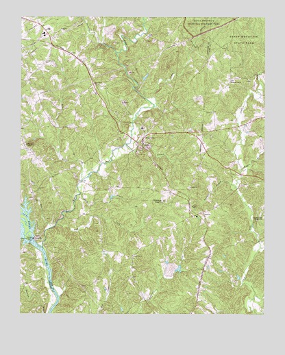
Kings Creek, SC USGS Topographic Map
Click on map above to begin viewing in our Map Viewer.

This topographic map contains these locations and features:
Feature Name Type Latitude Longitude GNIS ID View Map
Bamburg School (historical)SchoolN35.1215°W81.4193°1228451View Map
Beech BranchStreamN35.0510°W81.4693°1220463View Map
Bells BranchStreamN35.0565°W81.4681°1245048View Map
Biggers BranchStreamN35.0604°W81.3870°1220743View Map
Blacksburg DivisionCivilN35.1144°W81.4920°1938201View Map
Blackwell LakeReservoirN35.0219°W81.4247°1238533View Map
Blalock CemeteryCemeteryN35.0904°W81.4406°1228461View Map
Bordens Ferry (historical)CrossingN35.0212°W81.4865°1235843View Map
Broad River Baptist ChurchChurchN35.0246°W81.4426°1246994View Map
Broad River School (historical)SchoolN35.0265°W81.4581°1233617View Map
Camp CemeteryCemeteryN35.1165°W81.4623°1228471View Map
Canaan CemeteryCemeteryN35.0535°W81.4134°1228472View Map
Canaan ChurchChurchN35.0535°W81.4129°1247135View Map
Cherokee - Kings Creek Volunteer Fire DepartmentBuildingN35.0615°W81.4876°2578462View Map
Dixon Gold MineMineN35.0618°W81.4198°1228507View Map
Dry BranchStreamN35.0424°W81.4979°1222108View Map
Dye CemeteryCemeteryN35.1157°W81.4915°1228513View Map
Ellis CemeteryCemeteryN35.1215°W81.4493°1228518View Map
Garner BranchStreamN35.0874°W81.4315°1222649View Map
Goode CemeteryCemeteryN35.1212°W81.4831°1228544View Map
Heathcock CemeteryCemeteryN35.0857°W81.4815°1228557View Map
Hopewell CemeteryCemeteryN35.0973°W81.4634°1228563View Map
Hopewell ChurchChurchN35.0971°W81.4620°1246058View Map
Island Ferry (historical)CrossingN35.0271°W81.4893°1228570View Map
Jefferson MountainSummitN35.0713°W81.4949°1231430View Map
Jumping BranchStreamN35.1101°W81.4509°1246213View Map
Kings CreekStreamN35.0282°W81.4881°987996View Map
Kings CreekPopulated PlaceN35.0740°W81.4368°1231450View Map
Kings Creek School (historical)SchoolN35.0749°W81.4359°1228573View Map
Manning BranchStreamN35.0715°W81.4465°1224296View Map
McGill School (historical)SchoolN35.0590°W81.4806°1228594View Map
Modler Pond Dam D-3420DamN35.0985°W81.4365°1239943View Map
Mount Sinai CemeteryCemeteryN35.0460°W81.4109°1233808View Map
Mount Sinai ChurchChurchN35.0460°W81.4109°1224799View Map
Mount View School (historical)SchoolN35.0779°W81.3995°1233809View Map
Mount View School (historical)SchoolN35.0971°W81.3934°1248879View Map
Mountain View ChurchChurchN35.0976°W81.3923°1249751View Map
Mullinax CemeteryCemeteryN35.1012°W81.4251°1228611View Map
Nells BranchStreamN35.0365°W81.4840°1220110View Map
Ninety Nine Island ChurchChurchN35.0479°W81.4929°1228615View Map
Ninety Nine Island Power PlantBuildingN35.0318°W81.4931°1228616View Map
Ninety Nine Island School (historical)SchoolN35.0412°W81.4918°1228617View Map
Ninety Nine Island School (historical)SchoolN35.0576°W81.4856°1228618View Map
Ninety-Nine Island ReservoirReservoirN35.0312°W81.4940°1238850View Map
Ninety-Nine Islands DamDamN35.0301°W81.4948°1238849View Map
Ninetynine Island DamDamN35.0312°W81.4940°1225055View Map
Oak Grove CemeteryCemeteryN35.1060°W81.4868°1228621View Map
Oak Grove Independent Baptist ChurchChurchN35.1062°W81.4862°1249918View Map
Oak Grove School (historical)SchoolN35.1062°W81.4868°1228622View Map
Piedmont SpringsPopulated PlaceN35.0751°W81.4026°1233845View Map
Saltlick BranchStreamN35.0532°W81.3890°1226297View Map
Smith CreekStreamN35.0071°W81.4798°1233912View Map
SmyrnaPopulated PlaceN35.0426°W81.4062°1231809View Map
Smyrna Associate Reformed Presbyterian ChurchChurchN35.0399°W81.4140°1233917View Map
Smyrna Baptist ChurchChurchN35.0521°W81.4229°1250943View Map
Smyrna Fire DepartmentBuildingN35.0427°W81.4084°2578384View Map
Smyrna School (historical)SchoolN35.0321°W81.4054°1233918View Map
South Carolina Noname 46001 D-3638 DamDamN35.0235°W81.4248°1238532View Map
Southern Gold MineMineN35.0496°W81.4609°1228654View Map
Stooping Pine Church (historical)ChurchN35.0240°W81.4415°1237463View Map
Stooping Pine School (historical)SchoolN35.0060°W81.4601°1233929View Map
Town of SmyrnaCivilN35.0420°W81.4094°2407357View Map
Wilburn (historical)Populated PlaceN35.0968°W81.4626°1228674View Map
Wolf CreekStreamN35.0379°W81.4809°1227678View Map
Woodland Park CampgroundLocaleN35.0396°W81.3792°1227699View Map
Zoar School (historical)SchoolN35.0854°W81.4009°1233994View Map

Note: Coordinates in the location and feature list above are referenced to NAD83 datum.


Copyright (C) 2008-2024 Ryan Niemi / Sunset Dynamics ... All Rights Reserved