TopoQuest Logo
Do you find TopoQuest useful?
Help keep TopoQuest running and adding new maps/features by donating!
Bitcoin:  19c7KJd3qBynnjoSw5npx9KScwjBe4ifkT
Litecoin:  LXs6TkuXGGXo1vDsWCkWVdjQX94eUKd6ui
Home View Maps Find Maps Find Places Resources & Links


Saluda, Virginia Topographic Map

USGS Map Title: Saluda, VA
USGS Map MRC: 37076E5
DRG (GeoTIFF) Download: o37076e5.tif


Neighboring USGS Topographic Map Quads:


  Church View, VA  
37076F6
 

  Urbanna, VA  
37076F5
 

  Irvington, VA  
37076F4
 

  Shacklefords, VA  
37076E6
 

  Saluda, VA  
37076E5
 

  Wilton, VA  
37076E4
 

  Gressitt, VA  
37076D6
 

  Gloucester, VA  
37076D5
 

  Ware Neck, VA  
37076D4


Map MRC Location:

N38°
W77°
N38°
W76°
H8 H7 H6 H5 H4 H3 H2 H1
G8 G7 G6 G5 G4 G3 G2 G1
F8 F7 F6 F5 F4 F3 F2 F1
E8 E7 E6 E5 E4 E3 E2 E1
D8 D7 D6 D5 D4 D3 D2 D1
C8 C7 C6 C5 C4 C3 C2 C1
B8 B7 B6 B5 B4 B3 B2 B1
A8 A7 A6 A5 A4 A3 A2 A1
N37°
W77°
N37°
W76°

Saluda, VA USGS 1:24K Topographic Map Preview:
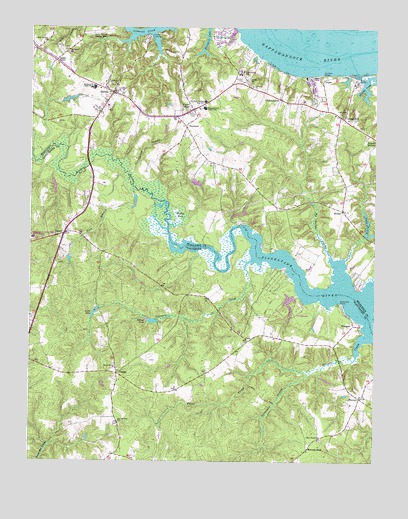
Saluda, VA USGS Topographic Map
Click on map above to begin viewing in our Map Viewer.

This topographic map contains these locations and features:
Feature Name Type Latitude Longitude GNIS ID View Map
Anderson PointCapeN37.5460°W76.5113°1462465View Map
Antioch ChurchChurchN37.6082°W76.5938°1462511View Map
Arrowhead Point AirportAirportN37.6235°W76.5973°1498832View Map
Burhans WharfLocaleN37.6118°W76.5188°1464106View Map
Calvary ChurchChurchN37.6082°W76.5441°1464282View Map
Carvers CreekStreamN37.5582°W76.5444°1464507View Map
CashLocaleN37.5351°W76.5450°1464516View Map
Centenary CemeteryCemeteryN37.6060°W76.5936°1464664View Map
Chesapeake Bay Governors SchoolSchoolN37.5644°W76.6239°2465288View Map
Christ ChurchChurchN37.6096°W76.5461°1464879View Map
Christ Church CemeteryCemeteryN37.6094°W76.5463°1739483View Map
ChristchurchPopulated PlaceN37.6049°W76.5344°1464885View Map
Christchurch SchoolSchoolN37.6129°W76.5497°1464886View Map
Community ChurchChurchN37.6004°W76.5119°1465141View Map
Cooks CornerPopulated PlaceN37.6015°W76.5661°1465196View Map
CooperPopulated PlaceN37.6107°W76.5186°1499297View Map
Courthouse SwampStreamN37.5815°W76.5888°1465320View Map
Cypress Shores DamDamN37.5501°W76.5280°1489868View Map
Cypress Shores LakeReservoirN37.5501°W76.5280°1489869View Map
Dragon SwampStreamN37.5676°W76.5750°1465941View Map
Emmanuel ChurchChurchN37.6182°W76.6116°1466287View Map
Foxes CreekStreamN37.5265°W76.5222°1466838View Map
FreeportPopulated PlaceN37.5396°W76.5072°1499452View Map
Freeport MarinaHarborN37.5391°W76.5042°2518563View Map
Gallaman SwampStreamN37.5265°W76.5222°1466961View Map
GlennsPopulated PlaceN37.5657°W76.6127°1477356View Map
Gloucester Volunteer Fire and Rescue Station 4BuildingN37.5165°W76.5021°2086281View Map
Grays DamDamN37.6035°W76.6130°1490423View Map
Grays PondReservoirN37.6041°W76.6115°1490424View Map
Haines PondReservoirN37.5405°W76.5803°1467636View Map
Haines Pond DamDamN37.5418°W76.5802°1489870View Map
HarcumPopulated PlaceN37.5185°W76.5052°1477393View Map
Harper CreekStreamN37.5360°W76.5019°1467764View Map
Headleys DamDamN37.5654°W76.5033°1490408View Map
HealysPopulated PlaceN37.5729°W76.5116°1477403View Map
Healys Mill (historical)LocaleN37.5660°W76.5094°1739490View Map
Healys PondReservoirN37.5678°W76.5020°1467890View Map
Hornets NestPopulated PlaceN37.5032°W76.5241°1477423View Map
Jones StoreLocaleN37.6151°W76.6158°1468863View Map
Locust HillPopulated PlaceN37.5993°W76.5111°1499679View Map
Locust Hill Post OfficePost OfficeN37.5986°W76.5117°2766469View Map
Meggs BaySwampN37.5707°W76.5715°1470343View Map
Middle Peninsula LandfillLocaleN37.5185°W76.6186°2519488View Map
Middle Peninsula Regional Security CenterBuildingN37.6080°W76.5936°2767116View Map
Middlesex CountyCivilN37.6227°W76.5059°1480147View Map
Middlesex County CourthouseBuildingN37.6065°W76.5950°1739498View Map
Middlesex County Public LibraryBuildingN37.5673°W76.6243°2519912View Map
Middlesex County Sheriff's OfficeBuildingN37.6073°W76.5950°2086107View Map
Middlesex County Sheriff's OfficeBuildingN37.6074°W76.5949°2331974View Map
Middlesex Elementary SchoolSchoolN37.5886°W76.5036°2465286View Map
Middlesex High SchoolSchoolN37.6079°W76.6022°1470423View Map
Mizpah Health Care Center Nursing HomeBuildingN37.6091°W76.5078°2520014View Map
My Ladys SwampStreamN37.5582°W76.5152°1471294View Map
New Mount Zion ChurchChurchN37.5107°W76.5922°1471479View Map
New UptonPopulated PlaceN37.5085°W76.5127°1761572View Map
Olive Branch ChurchChurchN37.5065°W76.5197°1471904View Map
PampaPopulated PlaceN37.5260°W76.5927°1477608View Map
Rappahannock Community College - Glenns CampusSchoolN37.5644°W76.6239°1761582View Map
Rappahannock Elementary SchoolSchoolN37.6021°W76.5613°1472980View Map
Riverside Convalescent Center at SaludaBuildingN37.6025°W76.5970°2520032View Map
Saint Andrews Church (historical)ChurchN37.5557°W76.6166°1761587View Map
Saint Clare Walker Elementary SchoolSchoolN37.6040°W76.5613°1473712View Map
Salem ChurchChurchN37.5271°W76.5938°1473951View Map
SaludaPopulated PlaceN37.6060°W76.5950°1498534View Map
Saluda Census Designated PlaceCensusN37.6053°W76.5938°2629037View Map
Saluda DistrictCivilN37.6071°W76.5292°1927486View Map
Saluda LandingLocaleN37.6224°W76.5813°1500017View Map
Saluda Landing Boat RampLocaleN37.6225°W76.5816°2518551View Map
Saluda Post OfficePost OfficeN37.6053°W76.5955°2519650View Map
South PondReservoirN37.5429°W76.6014°1474883View Map
StormontPopulated PlaceN37.5971°W76.5683°1477784View Map
Turks Ferry Bridge (historical)BridgeN37.5668°W76.5519°1739512View Map
Whiting CreekStreamN37.6118°W76.5066°1476681View Map
Zion BranchStreamN37.5790°W76.5872°1474378View Map
Zion Branch ChurchChurchN37.6210°W76.6188°1474379View Map
Zion Branch School (historical)SchoolN37.5610°W76.6013°1761598View Map

Note: Coordinates in the location and feature list above are referenced to NAD83 datum.


Copyright (C) 2008-2024 Ryan Niemi / Sunset Dynamics ... All Rights Reserved