TopoQuest Logo
Do you find TopoQuest useful?
Help keep TopoQuest running and adding new maps/features by donating!
Bitcoin:  19c7KJd3qBynnjoSw5npx9KScwjBe4ifkT
Litecoin:  LXs6TkuXGGXo1vDsWCkWVdjQX94eUKd6ui
Home View Maps Find Maps Find Places Resources & Links


Gressitt, Virginia Topographic Map

USGS Map Title: Gressitt, VA
USGS Map MRC: 37076D6
DRG (GeoTIFF) Download: o37076d6.tif


Neighboring USGS Topographic Map Quads:


  West Point, VA  
37076E7
 

  Shacklefords, VA  
37076E6
 

  Saluda, VA  
37076E5
 

  Toano, VA  
37076D7
 

  Gressitt, VA  
37076D6
 

  Gloucester, VA  
37076D5
 

  Norge, VA  
37076C7
 

  Williamsburg, VA  
37076C6
 

  Clay Bank, VA  
37076C5


Map MRC Location:

N38°
W77°
N38°
W76°
H8 H7 H6 H5 H4 H3 H2 H1
G8 G7 G6 G5 G4 G3 G2 G1
F8 F7 F6 F5 F4 F3 F2 F1
E8 E7 E6 E5 E4 E3 E2 E1
D8 D7 D6 D5 D4 D3 D2 D1
C8 C7 C6 C5 C4 C3 C2 C1
B8 B7 B6 B5 B4 B3 B2 B1
A8 A7 A6 A5 A4 A3 A2 A1
N37°
W77°
N37°
W76°

Gressitt, VA USGS 1:24K Topographic Map Preview:
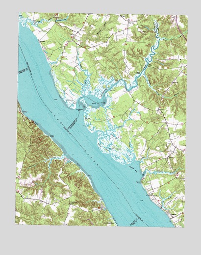
Gressitt, VA USGS Topographic Map
Click on map above to begin viewing in our Map Viewer.

This topographic map contains these locations and features:
Feature Name Type Latitude Longitude GNIS ID View Map
Adams CreekStreamN37.4276°W76.6922°1462363View Map
AdnerPopulated PlaceN37.4988°W76.6333°1495184View Map
Allmonds WharfLocaleN37.3938°W76.6519°1761540View Map
AllmondsvillePopulated PlaceN37.3935°W76.6508°1462423View Map
Barren PointCapeN37.4018°W76.6577°1462810View Map
Bell Rock LighthouseLocaleN37.4840°W76.7500°1463028View Map
BelleviewPopulated PlaceN37.4840°W76.7344°1495255View Map
Bland CreekStreamN37.4057°W76.6558°1463553View Map
CapahosicPopulated PlaceN37.3810°W76.6330°1464425View Map
Capahosic LandingLocaleN37.3801°W76.6358°1761545View Map
Captain John Smith National Historic TrailParkN37.4127°W76.6494°2783287View Map
Christensons CornerPopulated PlaceN37.3879°W76.7086°1478382View Map
Cowpen NeckCapeN37.3910°W76.6327°1465353View Map
Croaker LandingLocaleN37.4274°W76.7252°1495442View Map
Croaker Landing Boat RampLocaleN37.4271°W76.7251°2518527View Map
Fox CreekStreamN37.3860°W76.6422°1466824View Map
Gable BranchStreamN37.4288°W76.6827°1466938View Map
GressittPopulated PlaceN37.4874°W76.7077°1495621View Map
Gressitt PondReservoirN37.4961°W76.7175°1467537View Map
Gressitts DamDamN37.4960°W76.7216°1490170View Map
Guthrie CreekStreamN37.4515°W76.7000°1467615View Map
Haywood LandingLocaleN37.4657°W76.6583°1495670View Map
Hockley CreekStreamN37.4913°W76.7450°1468088View Map
Indian CreekStreamN37.4168°W76.6797°1468461View Map
Lake NorvellReservoirN37.3851°W76.6840°1779424View Map
Laurelwoods Estates Mobile Home ParkPopulated PlaceN37.4979°W76.6356°2519708View Map
Leigh CreekStreamN37.4129°W76.6575°1469303View Map
Lower King and Queen Volunteer Fire Department - Grassit StationBuildingN37.4893°W76.7092°2086194View Map
Meadow SwampStreamN37.4854°W76.6980°1470319View Map
Miller LandingLocaleN37.4704°W76.6536°1495950View Map
Millers Landing Boat RampLocaleN37.4694°W76.6545°2518544View Map
Morning Glory ChurchChurchN37.4604°W76.6355°1470740View Map
Morris BayBayN37.4479°W76.6908°1470751View Map
Mount FollySummitN37.4351°W76.7375°1495550View Map
Partridge LandingLocaleN37.4610°W76.6744°1496063View Map
PinettaPopulated PlaceN37.4154°W76.6383°1477626View Map
Plain ViewPopulated PlaceN37.4960°W76.6677°1472458View Map
Poplar Spring BranchStreamN37.4676°W76.6550°1472663View Map
Poropotank BayBayN37.4421°W76.7027°1472671View Map
Poropotank RiverStreamN37.4393°W76.7041°1472672View Map
Purtan BayBayN37.4088°W76.6616°1472875View Map
Purtan CreekStreamN37.4132°W76.6625°1472876View Map
Purtan IslandIslandN37.4213°W76.6766°1472877View Map
Red Bank LandingLocaleN37.4610°W76.6613°1496133View Map
RoanePopulated PlaceN37.4482°W76.7052°1496159View Map
Shacklefords ChapelChurchN37.4988°W76.6730°1474191View Map
SignpinePopulated PlaceN37.4438°W76.6450°1477751View Map
Sycamore LandingLocaleN37.4407°W76.7452°1496286View Map
Tanyard LandingLocaleN37.4549°W76.6669°1496292View Map
Tanyard Landing Boat RampLocaleN37.4548°W76.6680°2518554View Map
Taskinas CreekStreamN37.4165°W76.7141°1479709View Map
Tradition Golf Club at KiskiackLocaleN37.3877°W76.7481°2520175View Map
Tuckers MarinaHarborN37.4720°W76.7285°2518579View Map
Violet BankLeveeN37.4546°W76.6813°1476198View Map
West EndPopulated PlaceN37.4376°W76.6991°1496387View Map
Woods Mill SwampStreamN37.4860°W76.6447°1476970View Map
York River State ParkParkN37.4071°W76.7147°1779437View Map

Note: Coordinates in the location and feature list above are referenced to NAD83 datum.


Copyright (C) 2008-2024 Ryan Niemi / Sunset Dynamics ... All Rights Reserved