TopoQuest Logo
Do you find TopoQuest useful?
Help keep TopoQuest running and adding new maps/features by donating!
Bitcoin:  19c7KJd3qBynnjoSw5npx9KScwjBe4ifkT
Litecoin:  LXs6TkuXGGXo1vDsWCkWVdjQX94eUKd6ui
Home View Maps Find Maps Find Places Resources & Links


Saint Maurice, Louisiana Topographic Map

USGS Map Title: Saint Maurice, LA
USGS Map MRC: 31092G8
DRG (GeoTIFF) Download: o31092g8.tif


Neighboring USGS Topographic Map Quads:


  Campti, LA  
31093H1
 

  Coup Point, LA  
31092H8
 

  Calvin, LA  
31092H7
 

  Natchitoches North, LA  
31093G1
 

  Saint Maurice, LA  
31092G8
 

  Coochie Brake, LA  
31092G7
 

  Natchitoches South, LA  
31093F1
 

  Montgomery, LA  
31092F8
 

  Verda, LA  
31092F7


Map MRC Location:

N32°
W93°
N32°
W92°
H8 H7 H6 H5 H4 H3 H2 H1
G8 G7 G6 G5 G4 G3 G2 G1
F8 F7 F6 F5 F4 F3 F2 F1
E8 E7 E6 E5 E4 E3 E2 E1
D8 D7 D6 D5 D4 D3 D2 D1
C8 C7 C6 C5 C4 C3 C2 C1
B8 B7 B6 B5 B4 B3 B2 B1
A8 A7 A6 A5 A4 A3 A2 A1
N31°
W93°
N31°
W92°

Saint Maurice, LA USGS 1:24K Topographic Map Preview:
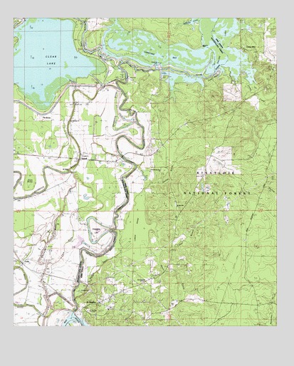
Saint Maurice, LA USGS Topographic Map
Click on map above to begin viewing in our Map Viewer.

This topographic map contains these locations and features:
Feature Name Type Latitude Longitude GNIS ID View Map
Allen Chivery DamDamN31.8485°W92.9585°556696View Map
Allen DamDamN31.8502°W92.9465°553284View Map
Bayou Poisson ArmeStreamN31.7835°W92.9849°558020View Map
Benjamin PointCapeN31.8638°W92.9104°541790View Map
Black LakeReservoirN31.8485°W92.9585°556697View Map
Black Lake BayouStreamN31.8571°W92.9490°553695View Map
Bourbeaux BayouStreamN31.8332°W92.9421°551102View Map
Brule BayouGutN31.7641°W92.9971°553797View Map
Camp AllenLocaleN31.8624°W92.8907°547168View Map
Cane BayouGutN31.7818°W92.9738°547182View Map
Cedar BluffCliffN31.8504°W92.9096°547198View Map
Cheechee BayBayN31.8604°W92.9277°547210View Map
Chevreuille BayouStreamN31.7560°W92.9810°547214View Map
Chivery DamDamN31.8477°W92.9579°553979View Map
Clear LakeReservoirN31.8479°W92.9588°554022View Map
Couley CreekStreamN31.8524°W92.8888°554103View Map
Dogwood TrailTrailN31.8299°W92.9149°548249View Map
Evergreen ChurchChurchN31.7643°W92.9643°548246View Map
Harmony ChurchChurchN31.8329°W92.9729°547440View Map
Harrisons Ferry (historical)CrossingN31.8099°W92.9485°549142View Map
Hassen BranchStreamN31.7821°W92.9354°547447View Map
Horseshoe LakeLakeN31.7852°W92.9601°554772View Map
Jacks BrakeSwampN31.8064°W92.9928°548248View Map
Lemon BrakeSwampN31.7891°W92.9416°547573View Map
Lemon BranchStreamN31.7788°W92.9321°547574View Map
Lick BranchStreamN31.8510°W92.9243°549154View Map
Lime BranchStreamN31.8721°W92.8774°547586View Map
Little Natches BayouStreamN31.7616°W92.9704°547610View Map
LuellaPopulated PlaceN31.7757°W92.9952°547635View Map
Mauvais CouleStreamN31.8738°W92.9035°548183View Map
Morning Star ChurchChurchN31.7982°W92.9229°547738View Map
Mount Olive Church (historical)ChurchN31.8104°W92.9718°549036View Map
Mount Pilgrim ChurchChurchN31.8135°W92.9729°547754View Map
New Enterprise ChurchChurchN31.7679°W92.9382°548245View Map
New Enterprise SchoolSchoolN31.7679°W92.9382°547767View Map
Old Morning Star ChurchChurchN31.8132°W92.9302°547798View Map
Pace CemeteryCemeteryN31.8402°W92.9710°541718View Map
Pace SchoolSchoolN31.8285°W92.9729°547807View Map
Redemption School (historical)SchoolN31.7591°W92.8843°1631043View Map
Saint Joseph ChurchChurchN31.8191°W92.9677°547928View Map
Saint MauricePopulated PlaceN31.7596°W92.9590°547937View Map
Saint Maurice Census Designated PlaceCensusN31.7614°W92.9388°2586708View Map
Saint Maurice PlantationLocaleN31.7566°W92.9649°541726View Map
Saint Maurice Post OfficePost OfficeN31.7588°W92.9582°1631045View Map
Saline BayouStreamN31.7546°W92.9727°555957View Map
Saline CemeteryCemeteryN31.8104°W92.9096°547945View Map
Saline Lake DamDamN31.8529°W92.9054°556728View Map
Strongs Ferry (historical)CrossingN31.7682°W92.9693°549182View Map
The ButteSummitN31.8335°W92.9868°541717View Map
The HorseshoeBendN31.7891°W92.9599°549008View Map
The Prairie (historical)AreaN31.8613°W92.9863°548901View Map
TrichellPopulated PlaceN31.8177°W92.9699°548247View Map
Upshaw CreekStreamN31.8707°W92.8902°548114View Map
Ward FiveCivilN31.7985°W92.8940°545291View Map

Note: Coordinates in the location and feature list above are referenced to NAD83 datum.


Copyright (C) 2008-2024 Ryan Niemi / Sunset Dynamics ... All Rights Reserved