TopoQuest Logo
Do you find TopoQuest useful?
Help keep TopoQuest running and adding new maps/features by donating!
Bitcoin:  19c7KJd3qBynnjoSw5npx9KScwjBe4ifkT
Litecoin:  LXs6TkuXGGXo1vDsWCkWVdjQX94eUKd6ui
Home View Maps Find Maps Find Places Resources & Links


Sahuarita, Arizona Topographic Map

USGS Map Title: Sahuarita, AZ
USGS Map MRC: 31110H8
DRG (GeoTIFF) Download: o31110h8.tif


Neighboring USGS Topographic Map Quads:


  San Xavier Mission, AZ  
32111A1
 

  Tucson SW, AZ  
32110A8
 

  Tucson SE, AZ  
32110A7
 

  Twin Buttes, AZ  
31111H1
 

  Sahuarita, AZ  
31110H8
 

  Corona De Tucson, AZ  
31110H7
 

  Esperanza Mill, AZ  
31111G1
 

  Green Valley, AZ  
31110G8
 

  Helvetia, AZ  
31110G7


Map MRC Location:

N32°
W111°
N32°
W110°
H8 H7 H6 H5 H4 H3 H2 H1
G8 G7 G6 G5 G4 G3 G2 G1
F8 F7 F6 F5 F4 F3 F2 F1
E8 E7 E6 E5 E4 E3 E2 E1
D8 D7 D6 D5 D4 D3 D2 D1
C8 C7 C6 C5 C4 C3 C2 C1
B8 B7 B6 B5 B4 B3 B2 B1
A8 A7 A6 A5 A4 A3 A2 A1
N31°
W111°
N31°
W110°

Sahuarita, AZ USGS 1:24K Topographic Map Preview:
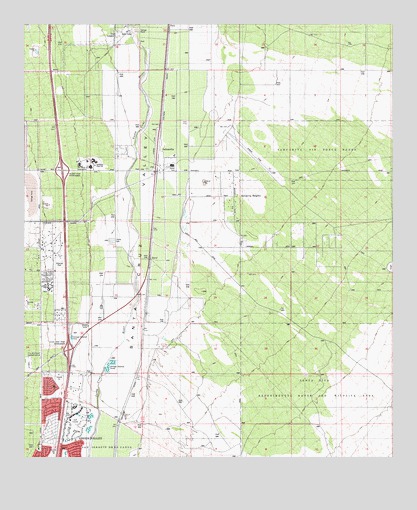
Sahuarita, AZ USGS Topographic Map
Click on map above to begin viewing in our Map Viewer.

This topographic map contains these locations and features:
Feature Name Type Latitude Longitude GNIS ID View Map
Air Force Facility Missile Site 8 (historical)MilitaryN31.9031°W110.9986°2499857View Map
Anamax ParkParkN31.9320°W110.9887°37140View Map
Anza Trail SchoolSchoolN31.9699°W110.9743°2544874View Map
Asarco Mineral Discovery CenterBuildingN31.9976°W110.9958°2623607View Map
Cornerstone Baptist ChurchChurchN31.9181°W110.9962°2623057View Map
Country Club of Green ValleyLocaleN31.8836°W110.9828°2622974View Map
DuvalPopulated PlaceN31.9317°W110.9581°28709View Map
Duval Mine Road InterchangeCrossingN31.9059°W110.9859°37279View Map
East SahuaritaPopulated PlaceN31.9429°W110.9284°1853157View Map
East Sahuarita Census Designated Place (historical)CensusN31.9396°W110.8998°2408036View Map
Edge High SchoolSchoolN31.9681°W110.9296°2544906View Map
First Assembly of GodChurchN31.9203°W110.9969°2623100View Map
Good Shepherd United Church of ChristChurchN31.9281°W110.9956°2623130View Map
Great Expectations AcademySchoolN31.9296°W110.9962°2543730View Map
Green Valley Baptist ChurchChurchN31.8872°W110.9957°2623141View Map
Green Valley Mortuary and Memorial GardensCemeteryN31.9095°W110.9938°2622948View Map
Green Valley Pueblo EstatesPopulated PlaceN31.8953°W110.9909°2622674View Map
Helmet Peak InterchangeCrossingN31.9581°W110.9879°37336View Map
KEZG-FM (Green Valley)TowerN31.9384°W110.9973°43351View Map
KGVY-AM (Green Valley)TowerN31.9262°W110.9965°45062View Map
Los Arboles Mobile Home ParkPopulated PlaceN31.9378°W110.9711°2622677View Map
Los Arroyos Shopping CenterLocaleN31.9120°W110.9820°2622422View Map
Our Lady of the Valley Roman Catholic ChurchChurchN31.8779°W110.9955°2623205View Map
Peace Evangelical Lutheran ChurchChurchN31.9295°W110.9942°2623212View Map
Pear TankReservoirN31.8954°W110.9840°22167View Map
PimaLocaleN31.9995°W110.9512°37469View Map
Pima County Public Library Joyner Green Valley BranchBuildingN31.8811°W110.9964°2623579View Map
Pima County Sheriff's Office Green Valley DistrictBuildingN31.8814°W110.9971°2751639View Map
Pima County Wastewater Management Green Valley Nutrient Removal FacilityLocaleN31.9021°W110.9706°2623638View Map
Quail Creek Country ClubLocaleN31.8898°W110.9467°2622970View Map
Rural - Metro Fire Department Station 79BuildingN31.9568°W110.9819°2657536View Map
SahuaritaPopulated PlaceN31.9576°W110.9556°33948View Map
Sahuarita Elementary SchoolSchoolN31.9623°W110.9495°37507View Map
Sahuarita HeightsPopulated PlaceN31.9501°W110.9254°37508View Map
Sahuarita Heights Mobile Home ParkPopulated PlaceN31.9383°W110.9262°2622676View Map
Sahuarita High SchoolSchoolN31.9593°W110.9731°37509View Map
Sahuarita Intermediate SchoolSchoolN31.9590°W110.9781°2544873View Map
Sahuarita LandfillLocaleN31.9488°W110.9929°2622369View Map
Sahuarita Middle SchoolSchoolN31.9607°W110.9772°37510View Map
Sahuarita Police DepartmentBuildingN31.9564°W110.9749°2622615View Map
Sahuarita Post OfficePost OfficeN31.9575°W110.9804°44869View Map
Sahuarita Primary SchoolSchoolN31.9598°W110.9818°2544823View Map
Sahuarita Railroad StationBuildingN31.9623°W110.9551°37511View Map
Sahuarita Town HallBuildingN31.9560°W110.9756°2623630View Map
Seventh Day Adventist Church of Green ValleyChurchN31.9226°W110.9963°2623283View Map
The Church of Jesus Christ of Latter Day SaintsChurchN31.9291°W110.9900°2623533View Map
Town of SahuaritaCivilN31.9328°W110.9654°2412592View Map
Unity Church in Green ValleyChurchN31.9306°W110.9911°2623560View Map

Note: Coordinates in the location and feature list above are referenced to NAD83 datum.


Copyright (C) 2008-2024 Ryan Niemi / Sunset Dynamics ... All Rights Reserved