TopoQuest Logo
Do you find TopoQuest useful?
Help keep TopoQuest running and adding new maps/features by donating!
Bitcoin:  19c7KJd3qBynnjoSw5npx9KScwjBe4ifkT
Litecoin:  LXs6TkuXGGXo1vDsWCkWVdjQX94eUKd6ui
Home View Maps Find Maps Find Places Resources & Links


Rockville, Missouri Topographic Map

USGS Map Title: Rockville, MO
USGS Map MRC: 38094A1
DRG (GeoTIFF) Download: o38094a1.tif


Neighboring USGS Topographic Map Quads:


  Pleasant Gap, MO  
38094B2
 

  Appleton City, MO  
38094B1
 

  Monegaw Springs NW, MO  
38093B8
 

  Papinville, MO  
38094A2
 

  Rockville, MO  
38094A1
 

  Taberville, MO  
38093A8
 

  Harwood, MO  
37094H2
 

  El Dorado Springs North, MO  
37094H1
 

  Tiffin, MO  
37093H8


Map MRC Location:

N39°
W95°
N39°
W94°
H8 H7 H6 H5 H4 H3 H2 H1
G8 G7 G6 G5 G4 G3 G2 G1
F8 F7 F6 F5 F4 F3 F2 F1
E8 E7 E6 E5 E4 E3 E2 E1
D8 D7 D6 D5 D4 D3 D2 D1
C8 C7 C6 C5 C4 C3 C2 C1
B8 B7 B6 B5 B4 B3 B2 B1
A8 A7 A6 A5 A4 A3 A2 A1
N38°
W95°
N38°
W94°

Rockville, MO USGS 1:24K Topographic Map Preview:
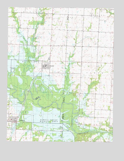
Rockville, MO USGS Topographic Map
Click on map above to begin viewing in our Map Viewer.

This topographic map contains these locations and features:
Feature Name Type Latitude Longitude GNIS ID View Map
Atkinson LakeLakeN38.0061°W94.0523°758179View Map
Atkinson Lake DamDamN38.0067°W94.0469°762903View Map
Barber LakeLakeN38.0154°W94.0560°713637View Map
Bell PondLakeN38.0053°W94.0935°748298View Map
Camp BranchStreamN38.0789°W94.0997°715251View Map
Campbell BranchStreamN38.0373°W94.0680°755853View Map
City of RockvilleCivilN38.0713°W94.0804°2396410View Map
City of Schell CityCivilN38.0192°W94.1167°2396553View Map
Decoy LakeLakeN38.0112°W94.0238°716782View Map
Dewey School (historical)SchoolN38.0011°W94.0330°748352View Map
Elm Grove School (historical)SchoolN38.0884°W94.0274°756021View Map
Fowler BranchStreamN38.0086°W94.0427°756073View Map
Granddad SloughStreamN38.0486°W94.1036°718682View Map
Haines School (historical)SchoolN38.1176°W94.0727°748377View Map
Heiman Field (historical)AirportN38.0620°W94.0797°758894View Map
Horseshoe LakeLakeN38.0566°W94.0849°719866View Map
Jones LakeLakeN38.0460°W94.0654°720421View Map
Levee Number Three DamDamN38.0139°W94.0553°762851View Map
Lost BranchStreamN38.0161°W94.0922°748511View Map
Maus LakeReservoirN38.0366°W94.1121°721993View Map
Meyer CemeteryCemeteryN38.1186°W94.0816°748299View Map
Miller BranchStreamN38.0352°W94.0887°748516View Map
Mononame 47 DamDamN38.0067°W94.0952°762938View Map
Mononame 78 DamDamN38.0100°W94.0836°762976View Map
Northeast Vernon County R-1 Elementary SchoolSchoolN38.0204°W94.1197°746138View Map
Old Folks PondLakeN38.0091°W94.0825°748296View Map
Osage School (historical)SchoolN38.0456°W94.0236°756485View Map
Panther CreekStreamN38.0481°W94.1030°723989View Map
Pecan HollowValleyN38.0053°W94.0472°756513View Map
Pleasant Grove Church (historical)ChurchN38.1200°W94.0808°748433View Map
Prairie Hill School (historical)SchoolN38.1178°W94.0348°756550View Map
Roberts LakeReservoirN38.1101°W94.0811°763478View Map
Roberts Lake DamDamN38.1117°W94.0819°763477View Map
RockvillePopulated PlaceN38.0714°W94.0797°725492View Map
Rockville CemeteryCemeteryN38.0647°W94.0666°725493View Map
Rockville Community Fire DepartmentBuildingN38.0703°W94.0794°2621354View Map
Rockville Post OfficePost OfficeN38.0700°W94.0831°2779535View Map
Rockville School (historical)SchoolN38.0742°W94.0802°746051View Map
Schell CityPopulated PlaceN38.0200°W94.1158°726097View Map
Schell City Post OfficePost OfficeN38.0184°W94.1147°2779546View Map
Schell City Volunteer Fire DepartmentBuildingN38.0192°W94.1147°2621043View Map
Schell LakeLakeN38.0148°W94.0732°758178View Map
Schell-Osage Reservoir Number 2ReservoirN38.0025°W94.0596°762904View Map
Schell-Osage Wildlife AreaParkN38.0167°W94.0711°758175View Map
See LakeLakeN38.0255°W94.0904°726182View Map
Shaw PondLakeN38.0095°W94.0859°748297View Map
Township of RockvilleCivilN38.0747°W94.1085°766306View Map
Township of TaberCivilN38.0550°W94.0000°767322View Map
Twin LakesLakeN38.0488°W94.0825°727926View Map
Wells BranchStreamN38.0264°W94.0405°756886View Map
West Prong Fowler BranchStreamN38.0050°W94.0669°748535View Map

Note: Coordinates in the location and feature list above are referenced to NAD83 datum.


Copyright (C) 2008-2024 Ryan Niemi / Sunset Dynamics ... All Rights Reserved