TopoQuest Logo
Do you find TopoQuest useful?
Help keep TopoQuest running and adding new maps/features by donating!
Bitcoin:  19c7KJd3qBynnjoSw5npx9KScwjBe4ifkT
Litecoin:  LXs6TkuXGGXo1vDsWCkWVdjQX94eUKd6ui
Home View Maps Find Maps Find Places Resources & Links


Rochester, Iowa Topographic Map

USGS Map Title: Rochester, IA
USGS Map MRC: 41091F2
DRG (GeoTIFF) Download: o41091f2.tif


Neighboring USGS Topographic Map Quads:


  Cedar Bluff, IA  
41091G3
 

  Tipton West, IA  
41091G2
 

  Tipton East, IA  
41091G1
 

  West Branch, IA  
41091F3
 

  Rochester, IA  
41091F2
 

  Lime City, IA  
41091F1
 

  West Liberty, IA  
41091E3
 

  Atalissa, IA  
41091E2
 

  Wilton, IA  
41091E1


Map MRC Location:

N42°
W92°
N42°
W91°
H8 H7 H6 H5 H4 H3 H2 H1
G8 G7 G6 G5 G4 G3 G2 G1
F8 F7 F6 F5 F4 F3 F2 F1
E8 E7 E6 E5 E4 E3 E2 E1
D8 D7 D6 D5 D4 D3 D2 D1
C8 C7 C6 C5 C4 C3 C2 C1
B8 B7 B6 B5 B4 B3 B2 B1
A8 A7 A6 A5 A4 A3 A2 A1
N41°
W92°
N41°
W91°

Rochester, IA USGS 1:24K Topographic Map Preview:
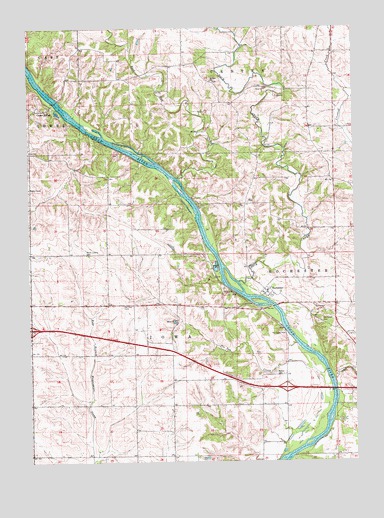
Rochester, IA USGS Topographic Map
Click on map above to begin viewing in our Map Viewer.

This topographic map contains these locations and features:
Feature Name Type Latitude Longitude GNIS ID View Map
Bethel CemeteryCemeteryN41.6503°W91.1561°454554View Map
Burnett CemeteryCemeteryN41.6681°W91.1835°2001680View Map
Cedar ValleyPopulated PlaceN41.7264°W91.2466°455259View Map
Cedar Valley ParkParkN41.7195°W91.2307°2001518View Map
Cedar Valley Post Office (historical)Post OfficeN41.7264°W91.2466°2001541View Map
Crooked CreekStreamN41.6486°W91.1332°455730View Map
Dunfee CemeteryCemeteryN41.6267°W91.1835°2001679View Map
Goodale CemeteryCemeteryN41.7222°W91.1557°2001665View Map
Green Bay BottomsFlatN41.6825°W91.2032°465327View Map
Hidden River CampgroundsLocaleN41.6634°W91.1357°2001566View Map
Hunts Cedar River CampgroundsLocaleN41.6431°W91.1265°2001567View Map
Interchange 259CrossingN41.6634°W91.2496°2001714View Map
Interchange 265CrossingN41.6461°W91.1515°2001713View Map
Kiser CemeteryCemeteryN41.7472°W91.1752°2001666View Map
Mathews CemeteryCemeteryN41.7334°W91.2363°2001667View Map
Mount Zion CemeteryCemeteryN41.7347°W91.1785°2001681View Map
Mount Zion ChurchChurchN41.7347°W91.1799°459363View Map
North Liberty CemeteryCemeteryN41.6852°W91.2290°459601View Map
PedeeLocaleN41.6706°W91.2207°466075View Map
Pedee POst Office (historical)Post OfficeN41.6706°W91.2090°2001540View Map
Pee Dee CemeteryCemeteryN41.6699°W91.2146°460055View Map
Pee Dee CreekStreamN41.6511°W91.1365°460057View Map
RochesterPopulated PlaceN41.6739°W91.1585°460704View Map
Rochester Census Designated PlaceCensusN41.6748°W91.1509°2629971View Map
Rochester ParkParkN41.6667°W91.1563°2001521View Map
Rochester Post Office (historical)Post OfficeN41.6739°W91.1585°2001539View Map
Rock CreekStreamN41.6767°W91.1696°460733View Map
Rock Run CreekStreamN41.7067°W91.1924°460745View Map
Stonemill QuarryMineN41.7303°W91.1550°2571515View Map
Township of IowaCivilN41.6497°W91.2020°468078View Map
Township of RochesterCivilN41.6646°W91.1304°468626View Map

Note: Coordinates in the location and feature list above are referenced to NAD83 datum.


Copyright (C) 2008-2024 Ryan Niemi / Sunset Dynamics ... All Rights Reserved