TopoQuest Logo
Do you find TopoQuest useful?
Help keep TopoQuest running and adding new maps/features by donating!
Bitcoin:  19c7KJd3qBynnjoSw5npx9KScwjBe4ifkT
Litecoin:  LXs6TkuXGGXo1vDsWCkWVdjQX94eUKd6ui
Home View Maps Find Maps Find Places Resources & Links


Rocheport, Missouri Topographic Map

USGS Map Title: Rocheport, MO
USGS Map MRC: 38092H5
DRG (GeoTIFF) Download: o38092h5.tif


Neighboring USGS Topographic Map Quads:


  New Franklin, MO  
39092A6
 

  Hilldale, MO  
39092A5
 

  Sturgeon SW, MO  
39092A4
 

  Boonville, MO  
38092H6
 

  Rocheport, MO  
38092H5
 

  Huntsdale, MO  
38092H4
 

  Lone Elm, MO  
38092G6
 

  Prairie Home, MO  
38092G5
 

  Jamestown, MO  
38092G4


Map MRC Location:

N39°
W93°
N39°
W92°
H8 H7 H6 H5 H4 H3 H2 H1
G8 G7 G6 G5 G4 G3 G2 G1
F8 F7 F6 F5 F4 F3 F2 F1
E8 E7 E6 E5 E4 E3 E2 E1
D8 D7 D6 D5 D4 D3 D2 D1
C8 C7 C6 C5 C4 C3 C2 C1
B8 B7 B6 B5 B4 B3 B2 B1
A8 A7 A6 A5 A4 A3 A2 A1
N38°
W93°
N38°
W92°

Rocheport, MO USGS 1:24K Topographic Map Preview:
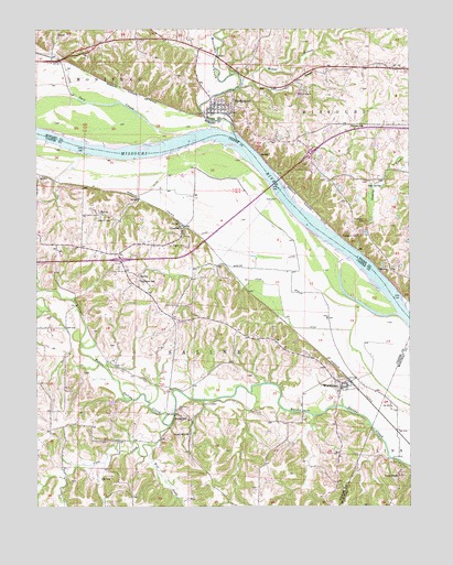
Rocheport, MO USGS Topographic Map
Click on map above to begin viewing in our Map Viewer.

This topographic map contains these locations and features:
Feature Name Type Latitude Longitude GNIS ID View Map
Bell BranchStreamN38.9859°W92.5527°713895View Map
Big Lick CemeteryCemeteryN38.9003°W92.5782°714191View Map
Big Manitou BluffsCliffN38.9453°W92.5219°1888893View Map
Big Muddy National Fish and Wildlife RefugeParkN38.9242°W92.5180°2765200View Map
Boone County Fire Protection District Station 2BuildingN38.9787°W92.5667°2621722View Map
Bruce School (historical)SchoolN38.8795°W92.5038°743617View Map
Cave CreekStreamN38.8959°W92.5813°715512View Map
City of RocheportCivilN38.9784°W92.5633°2396393View Map
Clayton CemeteryCemeteryN38.9428°W92.5746°715917View Map
Cooper County Fire Protection District Station 3BuildingN38.9246°W92.5808°2620545View Map
Copp ChapelChurchN38.8831°W92.5038°716299View Map
Diana BendsBendN38.9717°W92.6222°2118120View Map
Gooch MillLocaleN38.8992°W92.5785°729315View Map
Gooch Mill ChurchChurchN38.8942°W92.5744°729316View Map
Gum SpringSpringN38.9586°W92.5091°718927View Map
Highland ChurchChurchN38.9275°W92.5780°719568View Map
Highland School (historical)SchoolN38.9517°W92.6002°743968View Map
Highland School (historical)SchoolN38.9343°W92.5905°719579View Map
Liberty School (historical)SchoolN38.8778°W92.5616°743966View Map
Liberty School (historical)SchoolN38.8860°W92.5749°743967View Map
Linden School (historical)SchoolN38.9745°W92.5199°721101View Map
Lowland School (historical)SchoolN38.9214°W92.5455°743963View Map
McGill BranchStreamN38.9856°W92.5563°722110View Map
Moniteau CreekStreamN38.9739°W92.5663°722527View Map
Northern OzarksAreaN38.8753°W92.5005°754112View Map
Oak Grove School (historical)SchoolN38.8923°W92.6155°743965View Map
OvertonPopulated PlaceN38.9478°W92.5763°729364View Map
Overton Bottoms Conservation AreaParkN38.9506°W92.5447°2118160View Map
Robinsons DamDamN38.9317°W92.5985°764146View Map
Robinsons LakeReservoirN38.9317°W92.5985°764147View Map
RocheportPopulated PlaceN38.9800°W92.5641°725426View Map
Rocheport BendsBendN38.9706°W92.5767°2118123View Map
Rocheport Post OfficePost OfficeN38.9792°W92.5666°2782940View Map
Salt CreekStreamN38.9720°W92.5777°725970View Map
Schmidt CemeteryCemeteryN38.9500°W92.6049°726106View Map
Sinking CreekStreamN38.9417°W92.5180°726485View Map
Taylor's Landing AccessLocaleN38.9606°W92.5489°2118156View Map
Township of SalineCivilN38.9182°W92.5826°766538View Map
Village of WooldridgeCivilN38.9066°W92.5214°2399740View Map
Wolf CreekStreamN38.8906°W92.5869°729049View Map
WooldridgePopulated PlaceN38.9061°W92.5232°729414View Map
Wooldridge Post OfficePost OfficeN38.9064°W92.5229°2782691View Map
Wooldridge School (historical)SchoolN38.9078°W92.5252°743964View Map

Note: Coordinates in the location and feature list above are referenced to NAD83 datum.


Copyright (C) 2008-2024 Ryan Niemi / Sunset Dynamics ... All Rights Reserved