TopoQuest Logo
Do you find TopoQuest useful?
Help keep TopoQuest running and adding new maps/features by donating!
Bitcoin:  19c7KJd3qBynnjoSw5npx9KScwjBe4ifkT
Litecoin:  LXs6TkuXGGXo1vDsWCkWVdjQX94eUKd6ui
Home View Maps Find Maps Find Places Resources & Links


Rifle, Colorado Topographic Map

USGS Map Title: Rifle, CO
USGS Map MRC: 39107E7
DRG (GeoTIFF) Download: o39107e7.tif


Neighboring USGS Topographic Map Quads:


  Rio Blanco, CO  
39107F8
 

  Horse Mountain, CO  
39107F7
 

  Rifle Falls, CO  
39107F6
 

  Anvil Points, CO  
39107E8
 

  Rifle, CO  
39107E7
 

  Silt, CO  
39107E6
 

  Rulison, CO  
39107D8
 

  North Mamm Peak, CO  
39107D7
 

  Hunter Mesa, CO  
39107D6


Map MRC Location:

N40°
W108°
N40°
W107°
H8 H7 H6 H5 H4 H3 H2 H1
G8 G7 G6 G5 G4 G3 G2 G1
F8 F7 F6 F5 F4 F3 F2 F1
E8 E7 E6 E5 E4 E3 E2 E1
D8 D7 D6 D5 D4 D3 D2 D1
C8 C7 C6 C5 C4 C3 C2 C1
B8 B7 B6 B5 B4 B3 B2 B1
A8 A7 A6 A5 A4 A3 A2 A1
N39°
W108°
N39°
W107°

Rifle, CO USGS 1:24K Topographic Map Preview:
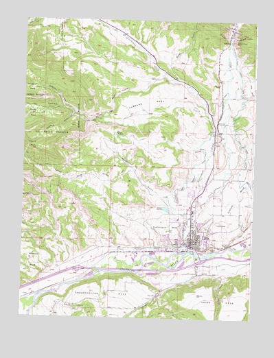
Rifle, CO USGS Topographic Map
Click on map above to begin viewing in our Map Viewer.

This topographic map contains these locations and features:
Feature Name Type Latitude Longitude GNIS ID View Map
Beaver CreekStreamN39.5039°W107.8667°174754View Map
Chambers PitMineN39.5291°W107.8131°1684093View Map
City of RifleCivilN39.5361°W107.7719°2410947View Map
Devils ParkFlatN39.5719°W107.8703°174049View Map
Doodlebug GulchValleyN39.5859°W107.8477°174038View Map
Estes GulchValleyN39.6004°W107.7926°173899View Map
Fravert ReservoirReservoirN39.5460°W107.7974°174039View Map
Goodrich GulchValleyN39.5857°W107.8478°174037View Map
Goodrich ParkFlatN39.5964°W107.8717°202201View Map
Government CreekStreamN39.5453°W107.7806°173889View Map
Grand HogbackRidgeN39.6186°W107.7548°173906View Map
Grand River Hospital and Medical CenterHospitalN39.5214°W107.7702°2695626View Map
Grand Tunnel DitchCanalN39.5725°W107.7795°174042View Map
Helmer GulchValleyN39.5149°W107.7950°174763View Map
Horse ParkFlatN39.5855°W107.8703°202202View Map
Hubbard GulchValleyN39.5462°W107.7916°174040View Map
Hubbard MesaSummitN39.5825°W107.8362°174035View Map
KKGD-AM (Rifle)TowerN39.5489°W107.7703°204060View Map
LacyLocaleN39.5091°W107.8695°202203View Map
Murphy ReservoirReservoirN39.5772°W107.8252°174041View Map
One Mile PondLakeN39.5314°W107.7620°174044View Map
Pioneer DitchCanalN39.5294°W107.8090°174047View Map
Prefontaine MesaSummitN39.5425°W107.7967°174048View Map
Ramsey GulchValleyN39.5186°W107.7661°174752View Map
RiflePopulated PlaceN39.5347°W107.7831°174045View Map
Rifle CreekStreamN39.5275°W107.7909°173898View Map
Rifle Creek Community ClubLocaleN39.5825°W107.7698°174043View Map
Rifle DivisionCivilN39.6131°W107.7975°1935556View Map
Rifle Fire Protection District Station 1 HeadquartersBuildingN39.5467°W107.7826°2666934View Map
Rifle Fire Protection District Station 3BuildingN39.5186°W107.7756°2667213View Map
Rifle GapGapN39.6164°W107.7642°174034View Map
Rifle Police DepartmentBuildingN39.5455°W107.7814°2757292View Map
Rifle Post OfficePost OfficeN39.5323°W107.7830°2750897View Map
Rose Hill CemeteryCemeteryN39.5380°W107.7748°174046View Map
Rosehill CemeteryCemeteryN39.5377°W107.7747°2750958View Map
Thirty Two Mile GulchValleyN39.6011°W107.8058°174036View Map
Yellow Slide GulchValleyN39.5619°W107.8146°174033View Map

Note: Coordinates in the location and feature list above are referenced to NAD83 datum.


Copyright (C) 2008-2024 Ryan Niemi / Sunset Dynamics ... All Rights Reserved