TopoQuest Logo
Do you find TopoQuest useful?
Help keep TopoQuest running and adding new maps/features by donating!
Bitcoin:  19c7KJd3qBynnjoSw5npx9KScwjBe4ifkT
Litecoin:  LXs6TkuXGGXo1vDsWCkWVdjQX94eUKd6ui
Home View Maps Find Maps Find Places Resources & Links


Richmond, Michigan Topographic Map

USGS Map Title: Richmond, MI
USGS Map MRC: 42082G7
DRG (GeoTIFF) Download: o42082g7.tif


Neighboring USGS Topographic Map Quads:


  Allenton, MI  
42082H8
 

  Memphis, MI  
42082H7
 

  Goodells, MI  
42082H6
 

  Armada, MI  
42082G8
 

  Richmond, MI  
42082G7
 

  Adair, MI  
42082G6
 

  Waldenburg, MI  
42082F8
 

  New Haven, MI  
42082F7
 

  New Baltimore, MI  
42082F6


Map MRC Location:

N43°
W83°
N43°
W82°
H8 H7 H6 H5 H4 H3 H2 H1
G8 G7 G6 G5 G4 G3 G2 G1
F8 F7 F6 F5 F4 F3 F2 F1
E8 E7 E6 E5 E4 E3 E2 E1
D8 D7 D6 D5 D4 D3 D2 D1
C8 C7 C6 C5 C4 C3 C2 C1
B8 B7 B6 B5 B4 B3 B2 B1
A8 A7 A6 A5 A4 A3 A2 A1
N42°
W83°
N42°
W82°

Richmond, MI USGS 1:24K Topographic Map Preview:
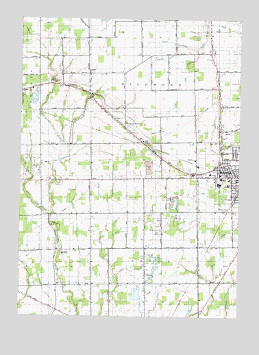
Richmond, MI USGS Topographic Map
Click on map above to begin viewing in our Map Viewer.

This topographic map contains these locations and features:
Feature Name Type Latitude Longitude GNIS ID View Map
Anderson DrainStreamN42.7992°W82.8258°620097View Map
Bailey ParkParkN42.8136°W82.7556°2648158View Map
Bates CemeteryCemeteryN42.8328°W82.8205°620736View Map
Beebe Street Memorial ParkParkN42.8139°W82.7517°2648087View Map
Boss LakeLakeN42.7975°W82.7860°1623090View Map
Cemetery CreekStreamN42.8209°W82.8483°622966View Map
City of RichmondCivilN42.8093°W82.7516°1626975View Map
Community Baptist ChurchChurchN42.8040°W82.7540°2648157View Map
Community of Christ ChurchChurchN42.8106°W82.7750°2648156View Map
Dixon DrainStreamN42.7992°W82.8258°624714View Map
First United Church of ChristChurchN42.8061°W82.7544°2648154View Map
First United Methodist ChurchChurchN42.8131°W82.7592°2648155View Map
Fistler DrainStreamN42.7648°W82.7658°626093View Map
Harrison DrainStreamN42.7753°W82.8260°627856View Map
Highbank CreekStreamN42.7925°W82.8574°628242View Map
Hill DrainStreamN42.7545°W82.8413°628279View Map
Independent ChurchChurchN42.7700°W82.8549°628953View Map
Jeffrey DrainStreamN42.8625°W82.7758°629250View Map
Jehovah's Witnesses Kingdom HallChurchN42.8242°W82.7624°2648153View Map
Lake ChaletLakeN42.7732°W82.7971°623040View Map
Lee SchoolSchoolN42.8056°W82.7560°630261View Map
Lenox Centre Burial GroundsCemeteryN42.7866°W82.7961°2648139View Map
Lenox Township Fire Department Station 2BuildingN42.8085°W82.7726°2620240View Map
Logg DrainStreamN42.8625°W82.7758°630885View Map
Norton DrainStreamN42.7842°W82.8213°633739View Map
Richards CemeteryCemeteryN42.8075°W82.8558°635862View Map
RichmondPopulated PlaceN42.8092°W82.7558°635886View Map
Richmond - Lenox Emergency Medical Services Ambulance Authority House 1 HeadquartersBuildingN42.8080°W82.7705°2662047View Map
Richmond - Lenox Emergency Medical Services Ambulance Authority House 2BuildingN42.8605°W82.7677°2662091View Map
Richmond CemeteryCemeteryN42.8261°W82.7608°1621383View Map
Richmond Center for the Performing Arts Historical MarkerParkN42.8135°W82.7601°2647816View Map
Richmond Community High SchoolSchoolN42.8092°W82.7660°2344560View Map
Richmond Fire DepartmentBuildingN42.8032°W82.7513°2648094View Map
Richmond Fire DepartmentBuildingN42.8126°W82.7586°2620235View Map
Richmond Middle SchoolSchoolN42.8058°W82.7611°2648152View Map
Richmond Place Mobile Home EstatesPopulated PlaceN42.8114°W82.7511°2648151View Map
Richmond StationLocaleN42.8072°W82.7503°2648148View Map
Ryall DrainStreamN42.8645°W82.7849°636428View Map
Saint Joseph NovitiateChurchN42.7761°W82.8505°636784View Map
Saint Joseph's AcademySchoolN42.8519°W82.8357°2340695View Map
Saint Joseph's Seminary CemeteryCemeteryN42.7746°W82.8493°2648118View Map
Saint Mary ChurchChurchN42.8448°W82.8741°636865View Map
Sanford Stone Historical MarkerParkN42.8144°W82.7561°2647823View Map
Smith DrainStreamN42.7670°W82.8194°638147View Map
Timberwood Golf ClubChurchN42.7874°W82.8734°2648097View Map
Township of LenoxCivilN42.7624°W82.7983°1626604View Map
Township of RichmondCivilN42.8525°W82.8024°1626976View Map
Trinity Lutheran ChurchChurchN42.8083°W82.7631°2648149View Map
Weller House Historical MarkerParkN42.8144°W82.7561°2647824View Map
Wheeler DrainStreamN42.8370°W82.8230°1616260View Map
Will L Lee SchoolSchoolN42.8050°W82.7555°2340014View Map
Willow Grove CemeteryCemeteryN42.8484°W82.8577°1616535View Map

Note: Coordinates in the location and feature list above are referenced to NAD83 datum.


Copyright (C) 2008-2024 Ryan Niemi / Sunset Dynamics ... All Rights Reserved