TopoQuest Logo
Do you find TopoQuest useful?
Help keep TopoQuest running and adding new maps/features by donating!
Bitcoin:  19c7KJd3qBynnjoSw5npx9KScwjBe4ifkT
Litecoin:  LXs6TkuXGGXo1vDsWCkWVdjQX94eUKd6ui
Home View Maps Find Maps Find Places Resources & Links


New Baltimore, Michigan Topographic Map

USGS Map Title: New Baltimore, MI
USGS Map MRC: 42082F6
DRG (GeoTIFF) Download: o42082f6.tif


Neighboring USGS Topographic Map Quads:


  Richmond, MI  
42082G7
 

  Adair, MI  
42082G6
 

  Rattle Run, MI  
42082G5
 

  New Haven, MI  
42082F7
 

  New Baltimore, MI  
42082F6
 

  Marine City, MI  
42082F5
 

  Mount Clemens East, MI  
42082E7
 

  Saint Clair Flats, MI  
42082E6
 

  Algonac, MI  
42082E5


Map MRC Location:

N43°
W83°
N43°
W82°
H8 H7 H6 H5 H4 H3 H2 H1
G8 G7 G6 G5 G4 G3 G2 G1
F8 F7 F6 F5 F4 F3 F2 F1
E8 E7 E6 E5 E4 E3 E2 E1
D8 D7 D6 D5 D4 D3 D2 D1
C8 C7 C6 C5 C4 C3 C2 C1
B8 B7 B6 B5 B4 B3 B2 B1
A8 A7 A6 A5 A4 A3 A2 A1
N42°
W83°
N42°
W82°

New Baltimore, MI USGS 1:24K Topographic Map Preview:
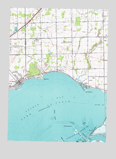
New Baltimore, MI USGS Topographic Map
Click on map above to begin viewing in our Map Viewer.

This topographic map contains these locations and features:
Feature Name Type Latitude Longitude GNIS ID View Map
All Saints ChurchChurchN42.6831°W82.6480°1624346View Map
Americana Estates Mobile Home ParkPopulated PlaceN42.7389°W82.7278°2582174View Map
Anchor BayBayN42.6500°W82.7166°1624350View Map
Anchor Bay High SchoolSchoolN42.7117°W82.7414°620080View Map
Anchor Bay Middle School NorthSchoolN42.6896°W82.7410°2343309View Map
Anchor Bay SchoolSchoolN42.7053°W82.6896°1624351View Map
AnchorvillePopulated PlaceN42.6911°W82.6885°1624352View Map
Anchorville Post OfficePost OfficeN42.6911°W82.6886°2581596View Map
Ashley Elementary SchoolSchoolN42.6865°W82.7372°2648229View Map
Baltimore ChannelChannelN42.6503°W82.6907°1624368View Map
Baptist MissionChurchN42.6836°W82.6627°1624370View Map
Bethel Temple ChurchChurchN42.6786°W82.7369°2648146View Map
Bouvier BayBayN42.6617°W82.6335°1624406View Map
Boyd Oil and Gas FieldOilfieldN42.7300°W82.7021°1624409View Map
Christ Lutheran ChurchChurchN42.6864°W82.7183°2648145View Map
City of New BaltimoreCivilN42.6840°W82.7384°1626796View Map
Country Meadows Montessori SchoolSchoolN42.6781°W82.6486°2582165View Map
Crapaud CreekStreamN42.6734°W82.7421°1625564View Map
Fair HavenPopulated PlaceN42.6792°W82.6538°1624519View Map
Fair Haven Post OfficePost OfficeN42.6786°W82.6517°2582166View Map
Fair Haven SchoolSchoolN42.6861°W82.6430°1624520View Map
First Baptist ChurchChurchN42.6887°W82.7451°2648144View Map
First Congregational ChurchChurchN42.6793°W82.7379°2648143View Map
Genow Creek HighwayChannelN42.6259°W82.6524°1624558View Map
Golden Hawk Golf ClubLocaleN42.7478°W82.7075°2582182View Map
Grand Pacific House Historical MarkerParkN42.6801°W82.7357°2647800View Map
Henry Ford Medical Center - New BaltimoreBuildingN42.6800°W82.7376°2343151View Map
Horseshoe CanalChannelN42.6425°W82.6532°1624613View Map
Ira Gas Storage FieldOilfieldN42.7145°W82.6302°1624624View Map
Ira Township Fire DepartmentBuildingN42.6913°W82.6687°2620006View Map
Lighthouse Elementary SchoolSchoolN42.6863°W82.7418°2648228View Map
MacDonald Elementary SchoolSchoolN42.7444°W82.7306°2582181View Map
Marsac CreekStreamN42.6850°W82.7071°1624712View Map
Marsac PointCapeN42.6836°W82.7063°1624713View Map
Meldrum DrainStreamN42.6864°W82.6607°1624725View Map
Motor City Drag StripLocaleN42.7181°W82.6771°1624757View Map
New BaltimorePopulated PlaceN42.6811°W82.7369°633313View Map
New Baltimore Fire DepartmentBuildingN42.6826°W82.7357°2619931View Map
New Baltimore Fire DepartmentBuildingN42.6825°W82.7357°2648233View Map
New Baltimore Historical MarkerParkN42.6803°W82.7378°2647810View Map
New Baltimore LibraryBuildingN42.6800°W82.7338°2648232View Map
New Baltimore Police DepartmentBuildingN42.6792°W82.7340°2648231View Map
New Hope Full Gospel ChurchChurchN42.6900°W82.7278°2648142View Map
North Channel PointCapeN42.6400°W82.6682°1624785View Map
North Channel Saint Clair RiverStreamN42.6435°W82.6880°1624255View Map
North Channel Shooting Club Historical MarkerParkN42.6274°W82.6464°2581674View Map
North HighwayChannelN42.6370°W82.6449°1624787View Map
Palms SchoolSchoolN42.7209°W82.6294°1624809View Map
PetersPopulated PlaceN42.7445°W82.6316°1624819View Map
Peters Post Office (historical)Post OfficeN42.7444°W82.6317°2581489View Map
Richmond Rest AreaLocaleN42.7431°W82.7203°2581605View Map
Sacred Heart CemeteryCemeteryN42.6953°W82.6894°1624876View Map
Saint John's Lutheran ChurchChurchN42.6800°W82.7378°2648141View Map
Saint John's Lutheran ChurchChurchN42.6803°W82.7381°2082731View Map
Saint John's Lutheran Church Historical MarkerParkN42.6803°W82.7378°2647811View Map
Saint Mary Queen of Creation ChurchChurchN42.6792°W82.7364°2648234View Map
Saint Mary Queen of Creation SchoolSchoolN42.6783°W82.7364°2648140View Map
Saint Marys CemeteryCemeteryN42.6953°W82.6880°1624896View Map
Saint Paul's Lutheran CemeteryCemeteryN42.7447°W82.6314°2581639View Map
Saint Paul's Lutheran ChurchChurchN42.7444°W82.6322°2582179View Map
Saint Peter's Lutheran CemeteryCemeteryN42.7025°W82.6283°2581643View Map
Saint Peters ChurchChurchN42.7025°W82.6291°1624904View Map
Swan CreekStreamN42.6748°W82.6499°1624972View Map
Swan Creek PointCapeN42.6725°W82.6527°1624973View Map
Township of IraCivilN42.6957°W82.6624°1626524View Map
Walter and Mary Burke ParkParkN42.6781°W82.7344°2648643View Map
Wards Long Acres AirportAirportN42.7289°W82.6681°1624322View Map

Note: Coordinates in the location and feature list above are referenced to NAD83 datum.


Copyright (C) 2008-2024 Ryan Niemi / Sunset Dynamics ... All Rights Reserved