TopoQuest Logo
Do you find TopoQuest useful?
Help keep TopoQuest running and adding new maps/features by donating!
Bitcoin:  19c7KJd3qBynnjoSw5npx9KScwjBe4ifkT
Litecoin:  LXs6TkuXGGXo1vDsWCkWVdjQX94eUKd6ui
Home View Maps Find Maps Find Places Resources & Links


Richard, Louisiana Topographic Map

USGS Map Title: Richard, LA
USGS Map MRC: 30092D3
DRG (GeoTIFF) Download: o30092d3.tif


Neighboring USGS Topographic Map Quads:


  Eunice North, LA  
30092E4
 

  Chataignier, LA  
30092E3
 

  Lawtell, LA  
30092E2
 

  Eunice South, LA  
30092D4
 

  Richard, LA  
30092D3
 

  Church Point, LA  
30092D2
 

  Iota, LA  
30092C4
 

  Branch, LA  
30092C3
 

  Mire, LA  
30092C2


Map MRC Location:

N31°
W93°
N31°
W92°
H8 H7 H6 H5 H4 H3 H2 H1
G8 G7 G6 G5 G4 G3 G2 G1
F8 F7 F6 F5 F4 F3 F2 F1
E8 E7 E6 E5 E4 E3 E2 E1
D8 D7 D6 D5 D4 D3 D2 D1
C8 C7 C6 C5 C4 C3 C2 C1
B8 B7 B6 B5 B4 B3 B2 B1
A8 A7 A6 A5 A4 A3 A2 A1
N30°
W93°
N30°
W92°

Richard, LA USGS 1:24K Topographic Map Preview:
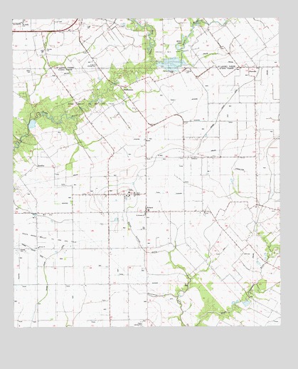
Richard, LA USGS Topographic Map
Click on map above to begin viewing in our Map Viewer.

This topographic map contains these locations and features:
Feature Name Type Latitude Longitude GNIS ID View Map
Acadia AcademySchoolN30.4299°W92.3212°532071View Map
Bayou DozaStreamN30.4808°W92.3099°559942View Map
Bayou Mallet Oil and Gas FieldOilfieldN30.4594°W92.3329°553488View Map
Blaise Lejuene GullyStreamN30.3877°W92.2982°553709View Map
Briscoe School (historical)SchoolN30.4296°W92.2512°544706View Map
Carron CemeteryCemeteryN30.4796°W92.3687°560367View Map
Coe (historical)Populated PlaceN30.4288°W92.3390°549391View Map
Courtville CemeteryCemeteryN30.4874°W92.3607°560499View Map
Daly School (historical)SchoolN30.3924°W92.3637°544710View Map
Francois CemeteryCemeteryN30.4788°W92.2943°541893View Map
Fruge CemeteryCemeteryN30.4971°W92.3404°1628679View Map
Grande Coulee DitchCanalN30.4099°W92.3457°535350View Map
Hornsby School (historical)SchoolN30.4216°W92.2857°544719View Map
HundleyPopulated PlaceN30.4410°W92.3662°543319View Map
Hundley School (historical)SchoolN30.4408°W92.3640°544720View Map
KJJB-FM (Eunice)TowerN30.4933°W92.3737°1633056View Map
Light and Tie School (historical)SchoolN30.4069°W92.3218°544724View Map
Luscombe Lane 1 Airport (historical)AirportN30.4286°W92.3181°2676776View Map
Miller LakeReservoirN30.4886°W92.2977°1627666View Map
Miller Lake DamDamN30.4874°W92.2976°1628802View Map
Mount Calvary CemeteryCemeteryN30.4962°W92.3715°1627709View Map
Mowata CemeteryCemeteryN30.4066°W92.3721°541897View Map
Mowato ChurchChurchN30.4074°W92.3643°537463View Map
Odon CemeteryCemeteryN30.4866°W92.3615°1627816View Map
Parish Governing Authority District 13 (historical)CivilN30.4380°W92.2726°1929837View Map
Parish Governing Authority District 7CivilN30.3844°W92.3424°1930172View Map
Pilgrims Rest Baptist ChurchChurchN30.4294°W92.3182°556647View Map
PitrevillePopulated PlaceN30.4799°W92.2615°1627941View Map
Pitreville School (historical)SchoolN30.4796°W92.2690°544735View Map
Point Noir School (historical)SchoolN30.3960°W92.2740°544736View Map
Prairie CottereauAreaN30.4502°W92.3043°544394View Map
PrudhommePopulated PlaceN30.4724°W92.3251°555737View Map
Prudhomme School (historical)SchoolN30.4752°W92.3068°544737View Map
RichardPopulated PlaceN30.4219°W92.3129°538582View Map
Richard Elementary SchoolSchoolN30.4224°W92.3118°544405View Map
Richard School (historical)SchoolN30.4291°W92.2526°544741View Map
Richard Volunteer Fire DepartmentBuildingN30.4267°W92.3122°2332719View Map
S and S Landing StripAirportN30.4813°W92.3357°552658View Map
Saint Edwards ChurchChurchN30.4205°W92.3135°541898View Map
Savoy School (historical)SchoolN30.4505°W92.2787°544742View Map
South Bayou Mallet Oil and Gas FieldOilfieldN30.4119°W92.3740°539481View Map
Trinity Baptist ChurchChurchN30.4961°W92.3559°2602880View Map
Ward SixCivilN30.4977°W92.3579°1628609View Map

Note: Coordinates in the location and feature list above are referenced to NAD83 datum.


Copyright (C) 2008-2024 Ryan Niemi / Sunset Dynamics ... All Rights Reserved