TopoQuest Logo
Do you find TopoQuest useful?
Help keep TopoQuest running and adding new maps/features by donating!
Bitcoin:  19c7KJd3qBynnjoSw5npx9KScwjBe4ifkT
Litecoin:  LXs6TkuXGGXo1vDsWCkWVdjQX94eUKd6ui
Home View Maps Find Maps Find Places Resources & Links


Mire, Louisiana Topographic Map

USGS Map Title: Mire, LA
USGS Map MRC: 30092C2
DRG (GeoTIFF) Download: o30092c2.tif


Neighboring USGS Topographic Map Quads:


  Richard, LA  
30092D3
 

  Church Point, LA  
30092D2
 

  Sunset, LA  
30092D1
 

  Branch, LA  
30092C3
 

  Mire, LA  
30092C2
 

  Carencro, LA  
30092C1
 

  Crowley East, LA  
30092B3
 

  Duson, LA  
30092B2
 

  Lafayette, LA  
30092B1


Map MRC Location:

N31°
W93°
N31°
W92°
H8 H7 H6 H5 H4 H3 H2 H1
G8 G7 G6 G5 G4 G3 G2 G1
F8 F7 F6 F5 F4 F3 F2 F1
E8 E7 E6 E5 E4 E3 E2 E1
D8 D7 D6 D5 D4 D3 D2 D1
C8 C7 C6 C5 C4 C3 C2 C1
B8 B7 B6 B5 B4 B3 B2 B1
A8 A7 A6 A5 A4 A3 A2 A1
N30°
W93°
N30°
W92°

Mire, LA USGS 1:24K Topographic Map Preview:
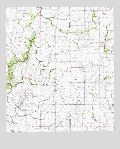
Mire, LA USGS Topographic Map
Click on map above to begin viewing in our Map Viewer.

This topographic map contains these locations and features:
Feature Name Type Latitude Longitude GNIS ID View Map
ArceneauxPopulated PlaceN30.2905°W92.2282°542933View Map
Arseneaux School (historical)SchoolN30.2841°W92.2315°544705View Map
Bosco Oil FieldOilfieldN30.3158°W92.1601°553756View Map
Branch Gas FieldOilfieldN30.3269°W92.2368°533369View Map
BristolPopulated PlaceN30.3710°W92.1385°560276View Map
CastillePopulated PlaceN30.3021°W92.2235°543062View Map
Church of the AssumptionChurchN30.3030°W92.1928°2601684View Map
Coulee CrocheStreamN30.3385°W92.1360°560489View Map
Cozy Acres Mobile Home ParkPopulated PlaceN30.2504°W92.1266°2600821View Map
DeshotelPopulated PlaceN30.3119°W92.2096°543141View Map
Deshotel School (historical)SchoolN30.3105°W92.2065°544711View Map
HigginbothamPopulated PlaceN30.3458°W92.1935°554709View Map
KADN-TV (Lafayette)TowerN30.3624°W92.2148°1633129View Map
KRVS-FM (Lafayette)TowerN30.2571°W92.1607°1633068View Map
KSMB-FM (Lafayette)TowerN30.3624°W92.2148°1633070View Map
MirePopulated PlaceN30.2999°W92.1937°543477View Map
Mire Elementary SchoolSchoolN30.2995°W92.1933°544378View Map
Mire Volunteer Fire Department District 7BuildingN30.2935°W92.1932°2332338View Map
Mount Calvary CemeteryCemeteryN30.3280°W92.2293°537294View Map
North Rayne Oil and Gas FieldOilfieldN30.2791°W92.2318°537744View Map
Parish Governing Authority District 10 (historical)CivilN30.2563°W92.2254°1929773View Map
Parish Governing Authority District 5CivilN30.2532°W92.2343°1930058View Map
Parish Governing Authority District 6CivilN30.3385°W92.2196°1930117View Map
Sievers FieldAirportN30.2675°W92.1842°2770266View Map
South Bosco Oil and Gas FieldOilfieldN30.2705°W92.1682°539484View Map
South Church Point Oil and Gas FieldOilfieldN30.3694°W92.2326°539489View Map
Stafford AirportAirportN30.3069°W92.1300°2717155View Map
Sunrise ChurchChurchN30.3560°W92.1418°1628313View Map

Note: Coordinates in the location and feature list above are referenced to NAD83 datum.


Copyright (C) 2008-2024 Ryan Niemi / Sunset Dynamics ... All Rights Reserved