TopoQuest Logo
Do you find TopoQuest useful?
Help keep TopoQuest running and adding new maps/features by donating!
Bitcoin:  19c7KJd3qBynnjoSw5npx9KScwjBe4ifkT
Litecoin:  LXs6TkuXGGXo1vDsWCkWVdjQX94eUKd6ui
Home View Maps Find Maps Find Places Resources & Links


Rainelle, West Virginia Topographic Map

USGS Map Title: Rainelle, WV
USGS Map MRC: 37080H7
DRG (GeoTIFF) Download: o37080h7.tif


Neighboring USGS Topographic Map Quads:


  Winona, WV  
38080A8
 

  Corliss, WV  
38080A7
 

  Quinwood, WV  
38080A6
 

  Danese, WV  
37080H8
 

  Rainelle, WV  
37080H7
 

  Rupert, WV  
37080H6
 

  Meadow Creek, WV  
37080G8
 

  Meadow Bridge, WV  
37080G7
 

  Dawson, WV  
37080G6


Map MRC Location:

N38°
W81°
N38°
W80°
H8 H7 H6 H5 H4 H3 H2 H1
G8 G7 G6 G5 G4 G3 G2 G1
F8 F7 F6 F5 F4 F3 F2 F1
E8 E7 E6 E5 E4 E3 E2 E1
D8 D7 D6 D5 D4 D3 D2 D1
C8 C7 C6 C5 C4 C3 C2 C1
B8 B7 B6 B5 B4 B3 B2 B1
A8 A7 A6 A5 A4 A3 A2 A1
N37°
W81°
N37°
W80°

Rainelle, WV USGS 1:24K Topographic Map Preview:
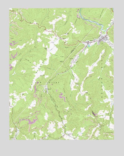
Rainelle, WV USGS Topographic Map
Click on map above to begin viewing in our Map Viewer.

This topographic map contains these locations and features:
Feature Name Type Latitude Longitude GNIS ID View Map
Aldrich CampLocaleN37.9898°W80.7912°1534860View Map
Arthurs Siding (historical)LocaleN37.8954°W80.8129°1556050View Map
BellwoodPopulated PlaceN37.9218°W80.8301°1535616View Map
Big Sewell Baptist ChurchChurchN37.9709°W80.8123°1535967View Map
Boggs CreekStreamN37.9565°W80.7501°1536193View Map
Boggs KnobSummitN37.9196°W80.7801°1553945View Map
Buster KnobSummitN37.9601°W80.8287°1536785View Map
Chestnut FlatFlatN37.9029°W80.8301°1537265View Map
Coal Hollow School (historical)SchoolN37.8993°W80.7548°1556268View Map
Crookshanks BranchStreamN37.9934°W80.7901°1537863View Map
Eureka School (historical)SchoolN37.9884°W80.8006°1556085View Map
Ford KnobSummitN37.9187°W80.8601°1554482View Map
Fork MountainSummitN37.9171°W80.8087°1539134View Map
Gould HollowValleyN37.9254°W80.8306°1539548View Map
Greenbrier Hills Golf ClubLocaleN37.9662°W80.7840°2634118View Map
Henson CemeteryCemeteryN37.8847°W80.8140°2586289View Map
Laurel Branch ChurchChurchN37.8790°W80.8287°1541395View Map
Lilly ParkPopulated PlaceN37.9504°W80.7984°1541963View Map
Little CreekStreamN37.9412°W80.8015°1542061View Map
Little Creek ChurchChurchN37.9276°W80.7940°1542071View Map
Little Sewell ChurchChurchN37.8993°W80.7554°1542215View Map
Little Sewell CreekStreamN37.9726°W80.7662°1542216View Map
MaywoodPopulated PlaceN37.9718°W80.8151°1549812View Map
Mill CreekStreamN37.9357°W80.8731°1556147View Map
Monclo Slurry DamDamN37.9001°W80.8331°1558962View Map
Monclo Slurry PondReservoirN37.9001°W80.8331°1558963View Map
Mountain School (historical)SchoolN37.9187°W80.7893°1556155View Map
Myles KnobSummitN37.9748°W80.8073°1544032View Map
Old Schoolhouse BranchStreamN37.9254°W80.8306°1556167View Map
Quinton BranchStreamN37.9237°W80.8301°1545354View Map
Quinton School (historical)SchoolN37.9051°W80.8418°1556183View Map
Quinwood Emergency Ambulance Service RainelleBuildingN37.9691°W80.7790°2581198View Map
RainellePopulated PlaceN37.9687°W80.7670°1555435View Map
Rainelle Christian AcademySchoolN37.9605°W80.7515°2088324View Map
Rainelle Elementary SchoolSchoolN37.9680°W80.7803°2088325View Map
Rainelle Elementary-Junior High School (historical)SchoolN37.9679°W80.7801°1556452View Map
Rainelle Police DepartmentBuildingN37.9691°W80.7695°2727924View Map
Rainelle Post OfficePost OfficeN37.9684°W80.7703°1559658View Map
Rainelle Public LibraryBuildingN37.9706°W80.7620°2727213View Map
Rainelle Volunteer Fire DepartmentBuildingN37.9686°W80.7652°2577856View Map
Rock Camp BranchStreamN37.9523°W80.8587°1545895View Map
Sewell CreekStreamN37.9782°W80.7593°1546587View Map
Sewell MountainSummitN37.9351°W80.8409°1555592View Map
ShawverPopulated PlaceN37.8868°W80.7656°1549926View Map
Sievy Bridge (historical)BridgeN37.9273°W80.8298°1556199View Map
SimsPopulated PlaceN37.9434°W80.8018°1555630View Map
Sims MountainSummitN37.9387°W80.7795°1546824View Map
Sims School (historical)SchoolN37.9621°W80.8520°1559373View Map
Sims School (historical)SchoolN37.9390°W80.7756°1556367View Map
Spring DalePopulated PlaceN37.8798°W80.8034°1547188View Map
Spring Dale Post OfficePost OfficeN37.8842°W80.8083°2774634View Map
Stevens KnobSummitN37.9493°W80.8112°1547398View Map
Sturgeon BranchStreamN37.9376°W80.8173°1547607View Map
Sturgeon Branch (historical)Populated PlaceN37.9379°W80.8179°1559374View Map
Sturgeon Branch ChurchChurchN37.9359°W80.8381°1547608View Map
Town of RainelleCivilN37.9678°W80.7718°2391381View Map
Turniphole MountainSummitN37.8796°W80.7595°1555841View Map
West Virginia State Police Troop 6 - Rainelle DetachmentBuildingN37.9661°W80.7760°2727923View Map
Wolfpen CreekStreamN37.9632°W80.7801°1549325View Map
Wolfpen RidgeRidgeN37.9543°W80.8156°1549333View Map
WRRL-AM (Rainelle)TowerN37.9579°W80.7623°1559739View Map

Note: Coordinates in the location and feature list above are referenced to NAD83 datum.


Copyright (C) 2008-2024 Ryan Niemi / Sunset Dynamics ... All Rights Reserved