TopoQuest Logo
Do you find TopoQuest useful?
Help keep TopoQuest running and adding new maps/features by donating!
Bitcoin:  19c7KJd3qBynnjoSw5npx9KScwjBe4ifkT
Litecoin:  LXs6TkuXGGXo1vDsWCkWVdjQX94eUKd6ui
Home View Maps Find Maps Find Places Resources & Links


Meadow Bridge, West Virginia Topographic Map

USGS Map Title: Meadow Bridge, WV
USGS Map MRC: 37080G7
DRG (GeoTIFF) Download: o37080g7.tif


Neighboring USGS Topographic Map Quads:


  Danese, WV  
37080H8
 

  Rainelle, WV  
37080H7
 

  Rupert, WV  
37080H6
 

  Meadow Creek, WV  
37080G8
 

  Meadow Bridge, WV  
37080G7
 

  Dawson, WV  
37080G6
 

  Hinton, WV  
37080F8
 

  Talcott, WV  
37080F7
 

  Alderson, WV  
37080F6


Map MRC Location:

N38°
W81°
N38°
W80°
H8 H7 H6 H5 H4 H3 H2 H1
G8 G7 G6 G5 G4 G3 G2 G1
F8 F7 F6 F5 F4 F3 F2 F1
E8 E7 E6 E5 E4 E3 E2 E1
D8 D7 D6 D5 D4 D3 D2 D1
C8 C7 C6 C5 C4 C3 C2 C1
B8 B7 B6 B5 B4 B3 B2 B1
A8 A7 A6 A5 A4 A3 A2 A1
N37°
W81°
N37°
W80°

Meadow Bridge, WV USGS 1:24K Topographic Map Preview:
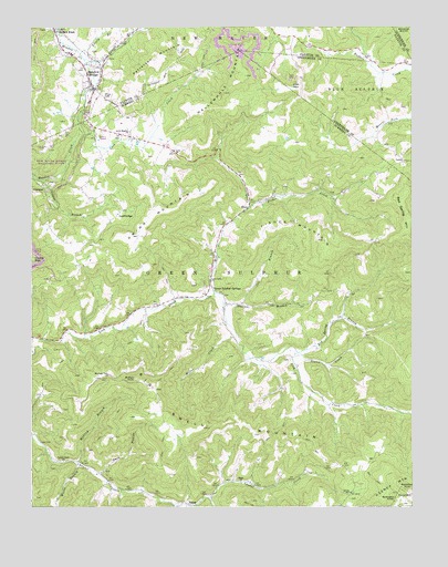
Meadow Bridge, WV USGS Topographic Map
Click on map above to begin viewing in our Map Viewer.

This topographic map contains these locations and features:
Feature Name Type Latitude Longitude GNIS ID View Map
Bachelors Hall School (historical)SchoolN37.7660°W80.7979°1556883View Map
Beech Grove School (historical)SchoolN37.8237°W80.8104°1556885View Map
Beelick KnobPopulated PlaceN37.8743°W80.8673°1535574View Map
Big Swell MountainSummitN37.7707°W80.8181°1556892View Map
Bragg CemeteryCemeteryN37.7925°W80.8723°2586367View Map
Buffalo KnobSummitN37.7834°W80.8406°1554024View Map
Buffalo School (historical)SchoolN37.8715°W80.7670°1556059View Map
ClaypoolPopulated PlaceN37.8329°W80.8706°1554141View Map
Claypool BranchStreamN37.8354°W80.8718°1537380View Map
Coon CreekStreamN37.8471°W80.8593°1537618View Map
Cox BranchStreamN37.8026°W80.8059°1537753View Map
Dark HollowValleyN37.7584°W80.8525°1538002View Map
Duncan BranchStreamN37.8032°W80.8118°1538429View Map
EltonPopulated PlaceN37.8285°W80.8031°1538698View Map
Elton Post OfficePost OfficeN37.8273°W80.8040°1559433View Map
Fisher CreekStreamN37.8279°W80.8029°1538992View Map
Fisher MountainSummitN37.8163°W80.7770°1554459View Map
Grapevine School (historical)SchoolN37.7932°W80.8665°1556917View Map
Green Sulphur SpringSpringN37.7946°W80.8095°1557802View Map
Green Sulphur SpringsPopulated PlaceN37.8079°W80.8162°1554604View Map
Green Sulphur Springs Post OfficePost OfficeN37.8098°W80.8162°1559439View Map
Gwinn MountainSummitN37.8273°W80.8334°1554623View Map
Gwinns Siding (historical)LocaleN37.8698°W80.8454°1556114View Map
Halidon School (historical)SchoolN37.7871°W80.7887°1556922View Map
Hunley School (historical)SchoolN37.8529°W80.7954°1556928View Map
Interchange 143CrossingN37.8051°W80.8120°1556930View Map
Irish MountainSummitN37.8593°W80.7873°1554779View Map
James Harless SpringSpringN37.8315°W80.7726°1557803View Map
Jones School (historical)SchoolN37.7785°W80.8648°1556933View Map
Lane School (historical)SchoolN37.8432°W80.8281°1556942View Map
Lane United Methodist ChurchChurchN37.8429°W80.8276°1541343View Map
Laurel BranchStreamN37.8665°W80.8573°1541392View Map
Laurel Creek ChurchChurchN37.7621°W80.8643°1541424View Map
LawnPopulated PlaceN37.8398°W80.7529°1554923View Map
Lick Creek ChurchChurchN37.8090°W80.8162°1541886View Map
Lily School (historical)SchoolN37.8315°W80.8254°1556947View Map
Little Meadow ChurchChurchN37.8479°W80.8423°1542170View Map
Lively BranchStreamN37.8676°W80.8584°1542269View Map
Lively School (historical)SchoolN37.7537°W80.7701°1542272View Map
LockbridgePopulated PlaceN37.8276°W80.8451°1554982View Map
Lockbridge Methodist ChurchChurchN37.8265°W80.8465°1558046View Map
Lockbridge Post OfficePost OfficeN37.8240°W80.8498°1559452View Map
Meadow BridgePopulated PlaceN37.8590°W80.8543°1543055View Map
Meadow Bridge Elementary SchoolSchoolN37.8683°W80.8624°1556142View Map
Meadow Bridge High SchoolSchoolN37.8679°W80.8613°2088267View Map
Meadow Bridge Junior-Senior High School (historical)SchoolN37.8679°W80.8618°1556143View Map
Meadow Bridge Post OfficePost OfficeN37.8525°W80.8570°2774598View Map
Meadow Bridge Public LibraryBuildingN37.8601°W80.8546°2727206View Map
Meadow Bridge Volunteer Fire DepartmentBuildingN37.8565°W80.8559°2577874View Map
Mill CreekStreamN37.8057°W80.8145°1543306View Map
Miller CreekStreamN37.7943°W80.8079°1543379View Map
Mountain View ChurchChurchN37.7846°W80.8495°1543876View Map
Mountain View School (historical)SchoolN37.7812°W80.8340°1556952View Map
Mudlick BranchStreamN37.7618°W80.8601°1543934View Map
New River DistrictCivilN37.7716°W80.7886°1928321View Map
Patterson MountainSummitN37.8655°W80.8334°1555314View Map
Patterson School (historical)SchoolN37.8604°W80.8351°1559371View Map
RampPopulated PlaceN37.7504°W80.8229°1555438View Map
Ramp ChurchChurchN37.7565°W80.8062°1545396View Map
Ramp Holiness ChurchChurchN37.7507°W80.8206°1558052View Map
Red Spring BranchStreamN37.7904°W80.7876°1545464View Map
Red Spring School (historical)SchoolN37.8032°W80.7715°1556967View Map
Slater CreekStreamN37.7904°W80.7876°1546919View Map
Springdale School (historical)SchoolN37.8723°W80.7923°1556201View Map
Tina (historical)Populated PlaceN37.8354°W80.8651°1556985View Map
Town of Meadow BridgeCivilN37.8613°W80.8562°2391294View Map
Victor School (historical)SchoolN37.7765°W80.7620°1558410View Map
Wallowhole MountainSummitN37.8673°W80.8062°1548743View Map
Wickline CemeteryCemeteryN37.8495°W80.8406°2586210View Map
Willis BranchStreamN37.7615°W80.8593°1549194View Map

Note: Coordinates in the location and feature list above are referenced to NAD83 datum.


Copyright (C) 2008-2024 Ryan Niemi / Sunset Dynamics ... All Rights Reserved