TopoQuest Logo
Do you find TopoQuest useful?
Help keep TopoQuest running and adding new maps/features by donating!
Bitcoin:  19c7KJd3qBynnjoSw5npx9KScwjBe4ifkT
Litecoin:  LXs6TkuXGGXo1vDsWCkWVdjQX94eUKd6ui
Home View Maps Find Maps Find Places Resources & Links


Quinton, Virginia Topographic Map

USGS Map Title: Quinton, VA
USGS Map MRC: 37077E2
DRG (GeoTIFF) Download: o37077e2.tif


Neighboring USGS Topographic Map Quads:


  Studley, VA  
37077F3
 

  Manquin, VA  
37077F2
 

  King William, VA  
37077F1
 

  Seven Pines, VA  
37077E3
 

  Quinton, VA  
37077E2
 

  Tunstall, VA  
37077E1
 

  Dutch Gap, VA  
37077D3
 

  Roxbury, VA  
37077D2
 

  Providence Forge, VA  
37077D1


Map MRC Location:

N38°
W78°
N38°
W77°
H8 H7 H6 H5 H4 H3 H2 H1
G8 G7 G6 G5 G4 G3 G2 G1
F8 F7 F6 F5 F4 F3 F2 F1
E8 E7 E6 E5 E4 E3 E2 E1
D8 D7 D6 D5 D4 D3 D2 D1
C8 C7 C6 C5 C4 C3 C2 C1
B8 B7 B6 B5 B4 B3 B2 B1
A8 A7 A6 A5 A4 A3 A2 A1
N37°
W78°
N37°
W77°

Quinton, VA USGS 1:24K Topographic Map Preview:
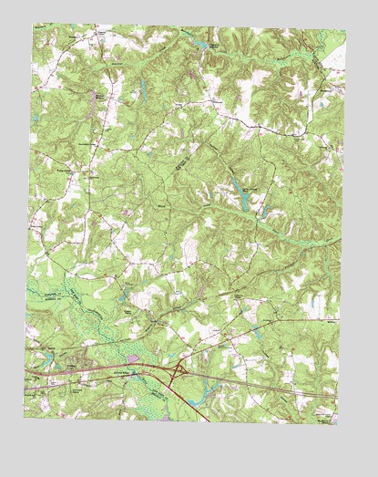
Quinton, VA USGS Topographic Map
Click on map above to begin viewing in our Map Viewer.

This topographic map contains these locations and features:
Feature Name Type Latitude Longitude GNIS ID View Map
Alexanders CornerPopulated PlaceN37.5868°W77.2230°1477066View Map
Antioch Baptist ChurchChurchN37.5126°W77.2439°1760361View Map
Antioch CemeteryCemeteryN37.5124°W77.2444°1760362View Map
Antioch SchoolSchoolN37.5126°W77.2441°1462518View Map
Beaties Millpond DamDamN37.6218°W77.2497°1490063View Map
Black Creek ChurchChurchN37.5763°W77.2264°1463479View Map
Blacks StoreLocaleN37.5396°W77.1666°1463527View Map
Boar SwampStreamN37.5263°W77.2272°1463613View Map
Bottoms BridgeBridgeN37.5149°W77.2053°1739789View Map
Bottoms BridgeLocaleN37.5143°W77.2075°1463695View Map
Bradley AcresPopulated PlaceN37.5176°W77.2314°1499155View Map
Brook ManorBuildingN37.5056°W77.1790°2083878View Map
Brookwood Golf CourseLocaleN37.5082°W77.1689°1739791View Map
Camp HanoverLocaleN37.6035°W77.2069°1464326View Map
Camp Hanover DamDamN37.6085°W77.2064°1490006View Map
Camp Hanover LakeReservoirN37.6085°W77.2064°1490007View Map
Camp MataokaLocaleN37.5363°W77.2100°1464341View Map
Camp OrapaxLocaleN37.5335°W77.2014°1464342View Map
Cant (historical)Populated PlaceN37.5293°W77.1689°1739792View Map
Cattail SwampStreamN37.5654°W77.1630°1464567View Map
Cattail Swamp DamDamN37.5668°W77.1647°1490452View Map
Cattail Swamp PondReservoirN37.5721°W77.1650°1464568View Map
Cold Harbor DistrictCivilN37.5982°W77.2448°1927155View Map
Currituck FarmsPopulated PlaceN37.5093°W77.2325°1499316View Map
Dispatch (historical)Populated PlaceN37.5229°W77.1830°1739796View Map
District 2CivilN37.5188°W77.1718°1927205View Map
Eberhard DamDamN37.5201°W77.2380°1490080View Map
Eberhard PondReservoirN37.5176°W77.2408°1490081View Map
Five Lakes SubdivisionPopulated PlaceN37.5060°W77.1744°2083879View Map
Flanagans Mill (historical)LocaleN37.6182°W77.1803°1748905View Map
Flanagans MillpondReservoirN37.6199°W77.1826°1466635View Map
Green MeadowsPopulated PlaceN37.5299°W77.2472°1760398View Map
HampsteadPopulated PlaceN37.6060°W77.1297°1499519View Map
Hanover County Fire - EMS Company 12 - Black Creek Volunteer Fire StationBuildingN37.5815°W77.2262°2075385View Map
Herman LakeReservoirN37.5721°W77.1650°1490453View Map
Higgins SwampStreamN37.5165°W77.2089°1468003View Map
Holts CornerPopulated PlaceN37.5601°W77.2494°1477421View Map
Hopewell ChurchChurchN37.5874°W77.1308°1468228View Map
Interchange 205CrossingN37.5160°W77.1897°1739798View Map
Kamp KentwoodLocaleN37.5421°W77.2111°1468912View Map
Kentwood Heights Baptist ChurchChurchN37.5202°W77.1829°2520393View Map
Liggans CornerPopulated PlaceN37.6218°W77.2255°1477490View Map
MeadowLocaleN37.5218°W77.2416°1470300View Map
New Kent County AirportAirportN37.5021°W77.1265°1498777View Map
NorthburyPopulated PlaceN37.6154°W77.1833°1480297View Map
Old Cannon EstatesPopulated PlaceN37.5024°W77.2428°1760420View Map
Orapax FarmsPopulated PlaceN37.5338°W77.2055°1499826View Map
Parsleys CreekStreamN37.6226°W77.1903°1472083View Map
Parsleys Mill (historical)LocaleN37.6040°W77.2264°1748920View Map
Parsleys Mill DamDamN37.6040°W77.2266°1490018View Map
Parsleys MillpondReservoirN37.6000°W77.2253°1502092View Map
Pine KnollPopulated PlaceN37.6121°W77.2489°1749043View Map
Prospect ChurchChurchN37.5990°W77.1894°1472809View Map
Providence ChurchChurchN37.5315°W77.1516°1472828View Map
Quinton Community CenterBuildingN37.5240°W77.1733°1472913View Map
Quinton Post OfficePost OfficeN37.5215°W77.1866°2766489View Map
Rising Mount Zion Baptist Church CemeteryCemeteryN37.5071°W77.2453°1760423View Map
Rising Mount Zion ChurchChurchN37.5074°W77.2455°1473242View Map
Rock Hill ChurchChurchN37.5849°W77.2497°1473374View Map
Saint Elizabeth Ann Seton Catholic ChurchChurchN37.5065°W77.1856°2504688View Map
School Number 1 (historical)SchoolN37.5096°W77.1605°1739820View Map
Sinclair ManorPopulated PlaceN37.6196°W77.2469°1749055View Map
Tabernacle CemeteryCemeteryN37.5899°W77.1447°1475423View Map
Tom Brooks DamDamN37.5051°W77.1830°1490450View Map
Tom Brooks LakeReservoirN37.5056°W77.1812°1490451View Map
Union ChurchChurchN37.5290°W77.1719°1476053View Map
Walden DamDamN37.6168°W77.1814°1490019View Map
Walden PondReservoirN37.6168°W77.1814°1490020View Map
WaterlooPopulated PlaceN37.5957°W77.1678°1480298View Map
WestwoodPopulated PlaceN37.6015°W77.1775°1477870View Map
Wharton Field (historical)AirportN37.5946°W77.2178°1498744View Map
Whites (historical)Populated PlaceN37.5565°W77.1314°1739825View Map
Wicker CornerPopulated PlaceN37.5779°W77.2325°1477877View Map
WindsorPopulated PlaceN37.5054°W77.2175°1760451View Map
WoodlawnPopulated PlaceN37.6218°W77.2330°1500346View Map
Woodview HillsPopulated PlaceN37.5182°W77.2255°1760453View Map

Note: Coordinates in the location and feature list above are referenced to NAD83 datum.


Copyright (C) 2008-2024 Ryan Niemi / Sunset Dynamics ... All Rights Reserved