TopoQuest Logo
Do you find TopoQuest useful?
Help keep TopoQuest running and adding new maps/features by donating!
Bitcoin:  19c7KJd3qBynnjoSw5npx9KScwjBe4ifkT
Litecoin:  LXs6TkuXGGXo1vDsWCkWVdjQX94eUKd6ui
Home View Maps Find Maps Find Places Resources & Links


Quicksand, Kentucky Topographic Map

USGS Map Title: Quicksand, KY
USGS Map MRC: 37083E3
DRG (GeoTIFF) Download: o37083e3.tif


Neighboring USGS Topographic Map Quads:


  Landsaw, KY  
37083F4
 

  Lee City, KY  
37083F3
 

  Seitz, KY  
37083F2
 

  Jackson, KY  
37083E4
 

  Quicksand, KY  
37083E3
 

  Guage, KY  
37083E2
 

  Canoe, KY  
37083D4
 

  Haddix, KY  
37083D3
 

  Noble, KY  
37083D2


Map MRC Location:

N38°
W84°
N38°
W83°
H8 H7 H6 H5 H4 H3 H2 H1
G8 G7 G6 G5 G4 G3 G2 G1
F8 F7 F6 F5 F4 F3 F2 F1
E8 E7 E6 E5 E4 E3 E2 E1
D8 D7 D6 D5 D4 D3 D2 D1
C8 C7 C6 C5 C4 C3 C2 C1
B8 B7 B6 B5 B4 B3 B2 B1
A8 A7 A6 A5 A4 A3 A2 A1
N37°
W84°
N37°
W83°

Quicksand, KY USGS 1:24K Topographic Map Preview:
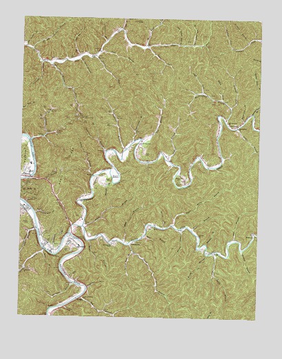
Quicksand, KY USGS Topographic Map
Click on map above to begin viewing in our Map Viewer.

This topographic map contains these locations and features:
Feature Name Type Latitude Longitude GNIS ID View Map
Andys BranchStreamN37.5790°W83.2621°485956View Map
Appalachia Police DepartmentBuildingN37.5050°W83.3008°2085834View Map
Arkansas BranchStreamN37.5309°W83.2766°486026View Map
Bach CemeteryCemeteryN37.5681°W83.3096°486171View Map
Bach Memorial ChurchChurchN37.5818°W83.2668°486172View Map
Bald HillSummitN37.5570°W83.3280°486260View Map
Bear BranchStreamN37.5268°W83.3627°486525View Map
Bear BranchStreamN37.5343°W83.3096°486526View Map
Ben Smith BranchStreamN37.5279°W83.2727°503730View Map
Bethlehem ChurchChurchN37.5195°W83.3718°487025View Map
Big BranchStreamN37.5084°W83.3421°487107View Map
Big BranchStreamN37.5390°W83.3410°487109View Map
Big Falling Rock BranchStreamN37.6143°W83.2857°487170View Map
Big Leslie BranchStreamN37.6115°W83.3696°487208View Map
Black Log BranchStreamN37.5826°W83.2577°487378View Map
Bradburn BranchStreamN37.5701°W83.3205°487787View Map
Breathitt CountyCivilN37.5216°W83.3241°516859View Map
Brewer CemeteryCemeteryN37.5392°W83.3705°487863View Map
Bricky BranchStreamN37.5265°W83.2760°487885View Map
Carpenter BranchStreamN37.5690°W83.3305°488955View Map
Clemons ChurchChurchN37.5345°W83.2810°489660View Map
Cockrill ForkStreamN37.6062°W83.3646°489763View Map
Dumb Betty BranchStreamN37.5387°W83.2946°491274View Map
Falcon HeliportAirportN37.5259°W83.3449°517407View Map
Falling Rock BranchStreamN37.5273°W83.3149°491955View Map
Fishtrap BranchStreamN37.5118°W83.3393°492134View Map
Flat BranchStreamN37.5312°W83.3199°492174View Map
Flat BranchStreamN37.6109°W83.3338°492176View Map
Frozen Lookout TowerTowerN37.5831°W83.3421°517152View Map
Gas Well HollowValleyN37.6094°W83.3452°492744View Map
Goodloe BranchStreamN37.5287°W83.2577°492979View Map
Grace ChapelChurchN37.6084°W83.3368°493063View Map
Gullett BranchStreamN37.6156°W83.3302°493467View Map
Hargis BranchStreamN37.5370°W83.2902°493740View Map
Holly ForkStreamN37.5909°W83.2691°494407View Map
Horsemill BranchStreamN37.5562°W83.3268°494594View Map
Julian Carroll AirportAirportN37.5939°W83.3173°517408View Map
KeckPopulated PlaceN37.6045°W83.3591°508371View Map
Kentucky River Medical CenterHospitalN37.5605°W83.3719°2660374View Map
Kings BranchStreamN37.5445°W83.3693°495755View Map
KragonPopulated PlaceN37.5068°W83.3443°508409View Map
Lick BranchStreamN37.5359°W83.3657°496457View Map
Lick BranchStreamN37.5740°W83.3121°496424View Map
Licking ForkStreamN37.5876°W83.2646°496523View Map
Little Falling Rock BranchStreamN37.6143°W83.2930°496719View Map
Little Jerusalem ChurchChurchN37.5076°W83.3405°496771View Map
Little Leslie BranchStreamN37.6126°W83.3732°496784View Map
McIntosh AmbulanceBuildingN37.5302°W83.3585°2719127View Map
Meatscaffold BranchStreamN37.5829°W83.2682°498013View Map
Meatscaffold ChurchChurchN37.5798°W83.2616°498014View Map
Meetinghouse BranchStreamN37.5384°W83.3471°498033View Map
Miller BranchStreamN37.5579°W83.3705°498314View Map
NoctorPopulated PlaceN37.5595°W83.3371°508713View Map
Open ForkStreamN37.5945°W83.2802°499947View Map
Orchard BranchStreamN37.6159°W83.2563°499982View Map
Palmer Memorial ChurchChurchN37.5726°W83.3130°500140View Map
PanbowlAreaN37.5668°W83.3741°500142View Map
Panbowl BranchStreamN37.5734°W83.3699°500143View Map
Panbowl ChurchChurchN37.5751°W83.3635°500144View Map
Pete BranchStreamN37.5365°W83.2843°500451View Map
Picnic HillSummitN37.5512°W83.3674°500565View Map
Pilot BranchStreamN37.6204°W83.3227°500637View Map
Pilot KnobSummitN37.6237°W83.3146°500645View Map
Poll BranchStreamN37.5326°W83.2605°501006View Map
Porter HollowValleyN37.5480°W83.3721°501148View Map
PortsmouthPopulated PlaceN37.5315°W83.3152°508861View Map
PressPopulated PlaceN37.5276°W83.2716°508873View Map
Press Howard ForkStreamN37.5351°W83.2505°501294View Map
QuicksandPopulated PlaceN37.5290°W83.3449°501479View Map
Quicksand ChurchChurchN37.5690°W83.3302°501480View Map
Quicksand CreekStreamN37.5348°W83.3491°501481View Map
Quicksand Fire DepartmentBuildingN37.5288°W83.3541°2637248View Map
Rainbow HillSummitN37.5559°W83.3352°501532View Map
Rehoboth Mountain MissionChurchN37.5304°W83.3263°501716View Map
Roaring Shoals BranchStreamN37.5856°W83.2530°502040View Map
Roark BranchStreamN37.5590°W83.3366°502044View Map
Roark RidgeRidgeN37.5612°W83.3530°502047View Map
Rose BranchStreamN37.5318°W83.3382°502315View Map
Round BottomBendN37.5579°W83.3249°502396View Map
Shucky Bean HollowValleyN37.5431°W83.3667°503471View Map
Slate BranchStreamN37.5656°W83.2968°503633View Map
Smith BranchStreamN37.5306°W83.3177°503737View Map
Snowden BranchStreamN37.5262°W83.3563°503859View Map
Snowden CemeteryCemeteryN37.5315°W83.3585°503860View Map
South Fork Quicksand CreekStreamN37.5379°W83.3418°503941View Map
Spice BranchStreamN37.6079°W83.3446°504063View Map
Spring BranchStreamN37.5373°W83.2996°504107View Map
Steel Road ForkStreamN37.6131°W83.3093°504301View Map
Steer ForkStreamN37.6129°W83.3088°504325View Map
StevensonPopulated PlaceN37.5809°W83.2610°509127View Map
Stidham ForkStreamN37.6131°W83.2652°504393View Map
Stillhouse BranchStreamN37.5143°W83.3468°504410View Map
Stray BranchStreamN37.5268°W83.3627°515755View Map
Strong ForkStreamN37.6059°W83.3602°504599View Map
Sugarcamp BranchStreamN37.5740°W83.3155°504687View Map
Trace ForkStreamN37.6095°W83.3363°505438View Map
Turner CemeteryCemeteryN37.5184°W83.3474°505656View Map
University of Kentucky Experimental FarmLocaleN37.5331°W83.3468°517305View Map
Williams CemeteryCemeteryN37.5568°W83.2918°506801View Map
Williams HillSummitN37.5581°W83.2902°506824View Map
WilstacyPopulated PlaceN37.5337°W83.2527°509381View Map

Note: Coordinates in the location and feature list above are referenced to NAD83 datum.


Copyright (C) 2008-2024 Ryan Niemi / Sunset Dynamics ... All Rights Reserved