TopoQuest Logo
Do you find TopoQuest useful?
Help keep TopoQuest running and adding new maps/features by donating!
Bitcoin:  19c7KJd3qBynnjoSw5npx9KScwjBe4ifkT
Litecoin:  LXs6TkuXGGXo1vDsWCkWVdjQX94eUKd6ui
Home View Maps Find Maps Find Places Resources & Links


Prospect, Virginia Topographic Map

USGS Map Title: Prospect, VA
USGS Map MRC: 37078C5
DRG (GeoTIFF) Download: o37078c5.tif


Neighboring USGS Topographic Map Quads:


  Holiday Lake, VA  
37078D6
 

  Andersonville, VA  
37078D5
 

  Willis Mountain, VA  
37078D4
 

  Pamplin, VA  
37078C6
 

  Prospect, VA  
37078C5
 

  Farmville, VA  
37078C4
 

  Madisonville, VA  
37078B6
 

  Abilene, VA  
37078B5
 

  Hampden Sydney, VA  
37078B4


Map MRC Location:

N38°
W79°
N38°
W78°
H8 H7 H6 H5 H4 H3 H2 H1
G8 G7 G6 G5 G4 G3 G2 G1
F8 F7 F6 F5 F4 F3 F2 F1
E8 E7 E6 E5 E4 E3 E2 E1
D8 D7 D6 D5 D4 D3 D2 D1
C8 C7 C6 C5 C4 C3 C2 C1
B8 B7 B6 B5 B4 B3 B2 B1
A8 A7 A6 A5 A4 A3 A2 A1
N37°
W79°
N37°
W78°

Prospect, VA USGS 1:24K Topographic Map Preview:
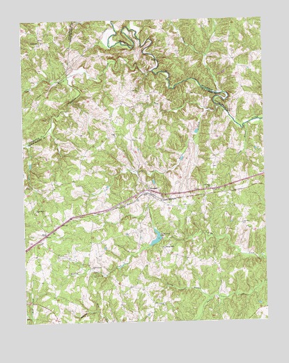
Prospect, VA USGS Topographic Map
Click on map above to begin viewing in our Map Viewer.

This topographic map contains these locations and features:
Feature Name Type Latitude Longitude GNIS ID View Map
Allens MillPopulated PlaceN37.2804°W78.5522°1477067View Map
Beazley FordCrossingN37.3588°W78.5547°1499104View Map
Brisentine PondReservoirN37.2935°W78.5647°1490682View Map
Brisentines DamDamN37.2935°W78.5647°1490681View Map
Buffalo Creek Number One DamDamN37.2835°W78.5564°1490655View Map
Cabin BranchStreamN37.3515°W78.6011°1464222View Map
Calvary ChurchChurchN37.2568°W78.5533°1464278View Map
Camp BranchStreamN37.3313°W78.5097°1464309View Map
Carter DamDamN37.3518°W78.5814°1490694View Map
District 601CivilN37.3037°W78.5560°1927284View Map
Ducker CreekStreamN37.3449°W78.5233°1466020View Map
ElamPopulated PlaceN37.2863°W78.6136°1477293View Map
First Rock School (historical)SchoolN37.3049°W78.5228°1492276View Map
Grand View LakeReservoirN37.2845°W78.5567°1467344View Map
Harris CreekStreamN37.3385°W78.5211°1467777View Map
HurtsvillePopulated PlaceN37.3654°W78.6158°1499592View Map
Little Rock CemeteryCemeteryN37.2904°W78.5122°1469634View Map
Little Rock ChurchChurchN37.3049°W78.5281°1469635View Map
Olive Branch CemeteryCemeteryN37.2968°W78.6194°1492322View Map
Olive Branch ChurchChurchN37.2968°W78.6186°1471903View Map
Orange DamDamN37.3385°W78.5181°1489301View Map
Peaks ChurchChurchN37.3279°W78.5767°1472154View Map
Peaks School (historical)SchoolN37.3340°W78.5786°1492325View Map
Plum CreekStreamN37.3374°W78.5269°1472526View Map
ProspectPopulated PlaceN37.3029°W78.5592°1499919View Map
Prospect CemeteryCemeteryN37.2988°W78.5492°1492333View Map
Prospect Christian AcademySchoolN37.2930°W78.6048°2499259View Map
Prospect Methodist ChurchChurchN37.2990°W78.5497°1492334View Map
Prospect Post OfficePost OfficeN37.3024°W78.5587°1492335View Map
Prospect School (historical)SchoolN37.3046°W78.5619°1492336View Map
Prospect Volunteer Fire DepartmentBuildingN37.3026°W78.5597°2086057View Map
Rattler BranchStreamN37.2549°W78.5883°1473012View Map
Saint James ChurchChurchN37.3004°W78.5542°1473731View Map
Saint Pauls ChurchChurchN37.3049°W78.5236°1473878View Map
Sleepy Hollow CemeteryCemeteryN37.2707°W78.6042°1946178View Map
Spring BranchStreamN37.2602°W78.5283°1474976View Map
Sulphur Spring CemeteryCemeteryN37.2693°W78.5903°1475311View Map
Sulphur Spring ChurchChurchN37.2724°W78.5906°1475312View Map
Vaughans CreekStreamN37.3540°W78.5569°1476161View Map
Venables BridgeBridgeN37.3368°W78.5194°1476170View Map

Note: Coordinates in the location and feature list above are referenced to NAD83 datum.


Copyright (C) 2008-2024 Ryan Niemi / Sunset Dynamics ... All Rights Reserved