TopoQuest Logo
Do you find TopoQuest useful?
Help keep TopoQuest running and adding new maps/features by donating!
Bitcoin:  19c7KJd3qBynnjoSw5npx9KScwjBe4ifkT
Litecoin:  LXs6TkuXGGXo1vDsWCkWVdjQX94eUKd6ui
Home View Maps Find Maps Find Places Resources & Links


Portland South, Michigan Topographic Map

USGS Map Title: Portland South, MI
USGS Map MRC: 42084G8
DRG (GeoTIFF) Download: o42084g8.tif


Neighboring USGS Topographic Map Quads:


  Ionia, MI  
42085H1
 

  Portland North, MI  
42084H8
 

  Westphalia, MI  
42084H7
 

  Woodbury, MI  
42085G1
 

  Portland South, MI  
42084G8
 

  Eagle, MI  
42084G7
 

  Saubee Lake, MI  
42085F1
 

  Hoytville, MI  
42084F8
 

  Needmore, MI  
42084F7


Map MRC Location:

N43°
W85°
N43°
W84°
H8 H7 H6 H5 H4 H3 H2 H1
G8 G7 G6 G5 G4 G3 G2 G1
F8 F7 F6 F5 F4 F3 F2 F1
E8 E7 E6 E5 E4 E3 E2 E1
D8 D7 D6 D5 D4 D3 D2 D1
C8 C7 C6 C5 C4 C3 C2 C1
B8 B7 B6 B5 B4 B3 B2 B1
A8 A7 A6 A5 A4 A3 A2 A1
N42°
W85°
N42°
W84°

Portland South, MI USGS 1:24K Topographic Map Preview:
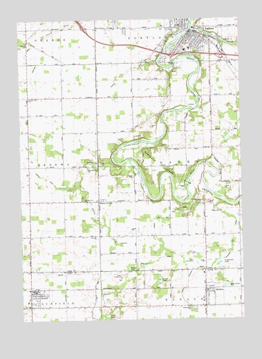
Portland South, MI USGS Topographic Map
Click on map above to begin viewing in our Map Viewer.

This topographic map contains these locations and features:
Feature Name Type Latitude Longitude GNIS ID View Map
Airbatco FieldAirportN42.7723°W84.9043°1624058View Map
Alton ParkParkN42.8708°W84.9083°2581654View Map
Bible Missionary ChurchChurchN42.7998°W84.9636°621275View Map
Brush Street ParkParkN42.8653°W84.9039°2581657View Map
Church of the NazareneChurchN42.8575°W84.8833°2582318View Map
City of PortlandCivilN42.8696°W84.8990°1626934View Map
Cryderman LakeLakeN42.7736°W84.8875°624159View Map
Cryderman Lake DrainCanalN42.7850°W84.8800°624160View Map
Danby CemeteryCemeteryN42.7989°W84.8983°624295View Map
Danby Post Office (historical)Post OfficeN42.7853°W84.8958°2581752View Map
East Sebewa CemeteryCemeteryN42.8134°W84.9608°625260View Map
Faith Bible ChurchChurchN42.7850°W84.9581°625788View Map
Family Health Center-PortlandHospitalN42.8511°W84.8769°2582328View Map
First Baptist ChurchChurchN42.8675°W84.9006°2582320View Map
First Congregational ChurchChurchN42.8678°W84.9000°2582319View Map
Gardner Hiar DrainCanalN42.7920°W84.9231°626648View Map
Grand Army of the Republic Hall Historical MarkerParkN42.7622°W84.9950°2569709View Map
Grange HallBuildingN42.8214°W84.8961°1625567View Map
Gregg LakeLakeN42.7516°W84.9519°627400View Map
Gunn and Ramsey DrainCanalN42.8123°W84.9914°627538View Map
Hiram Cure AirportAirportN42.7693°W84.9629°1624174View Map
Hoover LakeLakeN42.7664°W84.9222°628546View Map
Interchange 71CrossingN42.8597°W84.8875°2581790View Map
Interchange 73CrossingN42.8714°W84.9625°2581792View Map
Interchange 76CrossingN42.8603°W84.9117°2581791View Map
Jeffrey Post Office (historical)Post OfficeN42.8208°W84.8911°2581751View Map
Kent CornersLocaleN42.8714°W84.9558°629600View Map
Looking Glass RiverStreamN42.8711°W84.9022°631022View Map
Mathew CemeteryCemeteryN42.8645°W84.9953°631734View Map
Meadowbrook CemeteryCemeteryN42.7550°W84.9028°632054View Map
MullikenPopulated PlaceN42.7623°W84.8964°633112View Map
Mulliken District LibraryBuildingN42.7619°W84.8950°2575046View Map
Mulliken Post OfficePost OfficeN42.7619°W84.8956°2575047View Map
Mulliken StationLocaleN42.7625°W84.8917°2575036View Map
Mulliken United Methodist ChurchChurchN42.7742°W84.8972°2575045View Map
Oakwood Elementary SchoolSchoolN42.8628°W84.9031°2582327View Map
Parker ExtensionCanalN42.7578°W84.9086°634388View Map
Parkview Estates Mobile Home ParkPopulated PlaceN42.8556°W84.9356°2582331View Map
PortlandPopulated PlaceN42.8692°W84.9031°635311View Map
Portland Ambulance ServiceBuildingN42.8684°W84.8947°2661916View Map
Portland ChurchChurchN42.8420°W84.9944°635312View Map
Portland City CemeteryCemeteryN42.8630°W84.8950°2581777View Map
Portland City HallBuildingN42.8686°W84.9044°2582324View Map
Portland District LibraryBuildingN42.8678°W84.9050°2582323View Map
Portland Family Care CenterHospitalN42.8667°W84.9064°2582322View Map
Portland Fire DepartmentBuildingN42.8683°W84.8946°2582325View Map
Portland Middle SchoolSchoolN42.8622°W84.9061°2582326View Map
Portland Police DepartmentBuildingN42.8684°W84.8949°2582315View Map
Portland Post OfficePost OfficeN42.8692°W84.8969°2582330View Map
Portland State Game AreaParkN42.8025°W84.8930°635314View Map
Powers ParkParkN42.8708°W84.9056°2581655View Map
Roxand Township Fire DepartmentBuildingN42.7619°W84.8950°2636055View Map
Saint Andrew Lutheran ChurchChurchN42.8583°W84.9131°2582317View Map
Saint Patrick's ChurchChurchN42.8719°W84.9083°2582321View Map
Sebewa CornersPopulated PlaceN42.7995°W84.9558°637511View Map
Sebewa CreekStreamN42.8156°W84.9411°637512View Map
Sebewa Post Office (historical)Post OfficeN42.7994°W84.9558°2581731View Map
Seventh Day Adventist ChurchChurchN42.8642°W84.9086°2582316View Map
Stiffler DrainCanalN42.8528°W84.9392°638844View Map
SunfieldPopulated PlaceN42.7623°W84.9925°639074View Map
Sunfield District LibraryBuildingN42.7625°W84.9950°2574747View Map
Sunfield Elementary SchoolSchoolN42.7578°W84.9967°2574750View Map
Sunfield Fire DistrictBuildingN42.7627°W84.9935°2574748View Map
Sunfield Police DepartmentBuildingN42.7619°W84.9925°2574749View Map
Sunfield Post OfficePost OfficeN42.7625°W84.9939°2574746View Map
Sunfield StationLocaleN42.7625°W84.9914°2574779View Map
Sunfield Village HallBuildingN42.7619°W84.9925°2574745View Map
Sunset Ridge Mobile Home ParkPopulated PlaceN42.8694°W84.9361°2582333View Map
Sunset View Mobile Home ParkPopulated PlaceN42.8617°W84.8967°2582332View Map
Thompson FieldParkN42.8681°W84.9097°2581656View Map
Township of DanbyCivilN42.8137°W84.8965°1626158View Map
Twin LakesLakeN42.7724°W84.9302°1615256View Map
United Methodist ChurchChurchN42.8681°W84.9019°2582329View Map
United Methodist ChurchChurchN42.7597°W84.9908°2574751View Map
Village of MullikenCivilN42.7630°W84.8964°2399426View Map
Village of SunfieldCivilN42.7614°W84.9951°2399934View Map
William Toan ParkParkN42.8700°W84.9072°2581658View Map
Willow Wood Golf CourseLocaleN42.8167°W84.8847°2582314View Map
Wyman LakeLakeN42.7713°W84.9394°1616861View Map

Note: Coordinates in the location and feature list above are referenced to NAD83 datum.


Copyright (C) 2008-2024 Ryan Niemi / Sunset Dynamics ... All Rights Reserved