TopoQuest Logo
Do you find TopoQuest useful?
Help keep TopoQuest running and adding new maps/features by donating!
Bitcoin:  19c7KJd3qBynnjoSw5npx9KScwjBe4ifkT
Litecoin:  LXs6TkuXGGXo1vDsWCkWVdjQX94eUKd6ui
Home View Maps Find Maps Find Places Resources & Links


Pineland South, Texas Topographic Map

USGS Map Title: Pineland South, TX
USGS Map MRC: 31093B8
DRG (GeoTIFF) Download: o31093b8.tif


Neighboring USGS Topographic Map Quads:


  Bronson, TX  
31094C1
 

  Pineland North, TX  
31093C8
 

  Hemphill, TX  
31093C7
 

  Buck Bay, TX  
31094B1
 

  Pineland South, TX  
31093B8
 

  Hurricane Creek, TX  
31093B7
 

  McGee Bend, TX  
31094A1
 

  Harrisburg, TX  
31093A8
 

  Weeks Settlement, TX  
31093A7


Map MRC Location:

N32°
W94°
N32°
W93°
H8 H7 H6 H5 H4 H3 H2 H1
G8 G7 G6 G5 G4 G3 G2 G1
F8 F7 F6 F5 F4 F3 F2 F1
E8 E7 E6 E5 E4 E3 E2 E1
D8 D7 D6 D5 D4 D3 D2 D1
C8 C7 C6 C5 C4 C3 C2 C1
B8 B7 B6 B5 B4 B3 B2 B1
A8 A7 A6 A5 A4 A3 A2 A1
N31°
W94°
N31°
W93°

Pineland South, TX USGS 1:24K Topographic Map Preview:
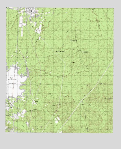
Pineland South, TX USGS Topographic Map
Click on map above to begin viewing in our Map Viewer.

This topographic map contains these locations and features:
Feature Name Type Latitude Longitude GNIS ID View Map
Berryman CemeteryCemeteryN31.1646°W93.9336°1381398View Map
BlackjackPopulated PlaceN31.1630°W93.9324°1381451View Map
BrookelandPopulated PlaceN31.1527°W93.9935°1383043View Map
Brookeland CemeteryCemeteryN31.1567°W93.9961°2575485View Map
Chinquapin BranchStreamN31.1557°W93.9155°1381633View Map
Chinquapin HillSummitN31.1757°W93.8788°1381636View Map
City of BrowndellCivilN31.1254°W93.9801°2409920View Map
City of PinelandCivilN31.2467°W93.9744°2411426View Map
Clear BranchStreamN31.1630°W93.9519°1381650View Map
Clear BranchStreamN31.2199°W93.8763°1381655View Map
Cobb BranchStreamN31.2480°W93.9005°1381670View Map
Curry CreekStreamN31.1760°W93.9985°1381729View Map
Devils Ford CreekStreamN31.1849°W93.9730°1381755View Map
Dinkhorse BranchStreamN31.1516°W93.8974°1381764View Map
East Prong McKim CreekStreamN31.1535°W93.9124°1381827View Map
Goodwill CemeteryCemeteryN31.2439°W93.9733°2575499View Map
Johnson CreekStreamN31.1616°W93.9949°1382085View Map
Johnson Family CemeteryCemeteryN31.1606°W93.9800°2575505View Map
KWYX-FM (Jasper)TowerN31.1535°W93.9905°1388008View Map
Little CreekStreamN31.2077°W93.9385°1382167View Map
Little Sandy CreekStreamN31.2116°W93.9707°1382183View Map
Lone Star CemeteryCemeteryN31.2053°W93.9889°2575509View Map
Lone Star ChurchChurchN31.2049°W93.9880°1382191View Map
Lowe CemeteryCemeteryN31.1600°W93.9644°2575511View Map
Lowe CemeteryParkN31.1599°W93.9638°1384602View Map
McElroyPopulated PlaceN31.1996°W93.9952°1382257View Map
McElroy CemeteryCemeteryN31.1972°W93.9229°1382258View Map
Oz BranchStreamN31.2257°W93.9282°1382446View Map
PinelandPopulated PlaceN31.2480°W93.9744°1382519View Map
Pineland City HallBuildingN31.2491°W93.9743°2753269View Map
Pineland Municipal AirportAirportN31.2335°W93.9819°1387321View Map
Pineland Police DepartmentBuildingN31.2491°W93.9743°2751173View Map
Pineland Volunteer Fire DepartmentBuildingN31.2491°W93.9734°2655179View Map
Remlig CemeteryCemeteryN31.1519°W93.9674°1382613View Map
Rock CreekStreamN31.1630°W93.9599°1382632View Map
Rush BranchStreamN31.2291°W93.9560°1382662View Map
Sixmile CreekStreamN31.2196°W93.8757°1383185View Map
Spring Hill CemeteryCemeteryN31.1385°W93.9877°1382799View Map
Spring Hill ChurchChurchN31.1260°W93.9799°1382801View Map
Stat Care Emergency Medical ServiceBuildingN31.2491°W93.9734°2721025View Map
StringtownPopulated PlaceN31.1919°W93.9257°1382817View Map
StumptownPopulated PlaceN31.1560°W93.9671°1382821View Map
Temple-Eastex Dam DDamN31.2452°W93.9719°1861173View Map
Temple-Eastex Lake DReservoirN31.2452°W93.9719°1861174View Map
Walker CreekStreamN31.1849°W93.9210°1382912View Map
Walker HillSummitN31.1727°W93.9035°1382913View Map
West Prong McKim CreekStreamN31.1532°W93.9124°1382940View Map

Note: Coordinates in the location and feature list above are referenced to NAD83 datum.


Copyright (C) 2008-2024 Ryan Niemi / Sunset Dynamics ... All Rights Reserved