TopoQuest Logo
Do you find TopoQuest useful?
Help keep TopoQuest running and adding new maps/features by donating!
Bitcoin:  19c7KJd3qBynnjoSw5npx9KScwjBe4ifkT
Litecoin:  LXs6TkuXGGXo1vDsWCkWVdjQX94eUKd6ui
Home View Maps Find Maps Find Places Resources & Links


Betheden, Mississippi Topographic Map

USGS Map Title: Betheden, MS
USGS Map MRC: 33088B8
DRG (GeoTIFF) Download: o33088b8.tif


Neighboring USGS Topographic Map Quads:


  Sturgis, MS  
33089C1
 

  Bradley, MS  
33088C8
 

  Bluff Lake, MS  
33088C7
 

  Louisville North, MS  
33089B1
 

  Betheden, MS  
33088B8
 

  Barge Lake, MS  
33088B7
 

  Louisville South, MS  
33089A1
 

  Boon, MS  
33088A8
 

  Fearns Springs, MS  
33088A7


Map MRC Location:

N34°
W89°
N34°
W88°
H8 H7 H6 H5 H4 H3 H2 H1
G8 G7 G6 G5 G4 G3 G2 G1
F8 F7 F6 F5 F4 F3 F2 F1
E8 E7 E6 E5 E4 E3 E2 E1
D8 D7 D6 D5 D4 D3 D2 D1
C8 C7 C6 C5 C4 C3 C2 C1
B8 B7 B6 B5 B4 B3 B2 B1
A8 A7 A6 A5 A4 A3 A2 A1
N33°
W89°
N33°
W88°

Betheden, MS USGS 1:24K Topographic Map Preview:
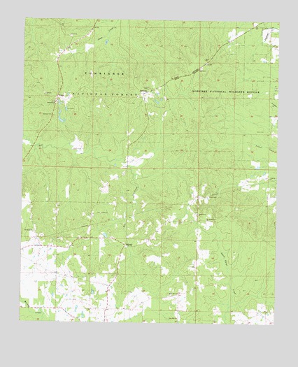
Betheden, MS USGS Topographic Map
Click on map above to begin viewing in our Map Viewer.

This topographic map contains these locations and features:
Feature Name Type Latitude Longitude GNIS ID View Map
Antioch CemeteryCemeteryN33.2432°W88.9770°707440View Map
Antioch ChurchChurchN33.2437°W88.9773°692408View Map
BethedenPopulated PlaceN33.2198°W88.9409°692550View Map
Betheden CemeteryCemeteryN33.2182°W88.9437°707443View Map
Betheden Lutheran ChurchChurchN33.2187°W88.9437°707444View Map
Betheden Volunteer Fire DepartmentBuildingN33.1665°W88.9659°2665862View Map
Bevil (historical)LocaleN33.2307°W88.9112°712191View Map
Bevil Hill CemeteryCemeteryN33.2307°W88.9126°707445View Map
Bevil Hill ChurchChurchN33.2301°W88.9134°692588View Map
Deposit (historical)Populated PlaceN33.2318°W88.9120°705342View Map
Dry CreekStreamN33.1890°W88.9467°705343View Map
Glenn CemeteryCemeteryN33.2046°W88.8814°693303View Map
Kinard Lake DamDamN33.2401°W88.9217°695478View Map
Liberty CemeteryCemeteryN33.1701°W88.9612°710045View Map
Liberty ChurchChurchN33.1701°W88.9606°693719View Map
LoakfomaPopulated PlaceN33.2482°W88.8873°711166View Map
MillcreekPopulated PlaceN33.1568°W88.9489°694002View Map
Mount Olive ChurchChurchN33.1371°W88.9226°694082View Map
Mount Pleasant Number 1 ChurchChurchN33.1623°W88.9937°694098View Map
Mount Pleasant Number 2 ChurchChurchN33.1676°W88.9092°694099View Map
Oliver CemeteryCemeteryN33.1665°W88.9234°694273View Map
Pleasant Grove CemeteryCemeteryN33.1704°W88.9139°710066View Map
Pleasant Grove ChurchChurchN33.1698°W88.9134°694425View Map
Rocky Hill ChurchChurchN33.1271°W88.9231°694598View Map
Singleton ChurchChurchN33.1851°W88.8781°694801View Map
Supervisor District 3CivilN33.1824°W88.9029°712145View Map
WebsterPopulated PlaceN33.2176°W88.9837°695108View Map
Webster CemeteryCemeteryN33.2154°W88.9839°695109View Map
White Lake DamDamN33.2085°W88.9817°695474View Map
White Lake DamDamN33.2168°W88.9834°695475View Map

Note: Coordinates in the location and feature list above are referenced to NAD83 datum.


Copyright (C) 2008-2024 Ryan Niemi / Sunset Dynamics ... All Rights Reserved