TopoQuest Logo
Do you find TopoQuest useful?
Help keep TopoQuest running and adding new maps/features by donating!
Bitcoin:  19c7KJd3qBynnjoSw5npx9KScwjBe4ifkT
Litecoin:  LXs6TkuXGGXo1vDsWCkWVdjQX94eUKd6ui
Home View Maps Find Maps Find Places Resources & Links


Bethany, North Carolina Topographic Map

USGS Map Title: Bethany, NC
USGS Map MRC: 36079C7
DRG (GeoTIFF) Download: o36079c7.tif


Neighboring USGS Topographic Map Quads:


  Mayodan, NC  
36079D8
 

  Southwest Eden, NC  
36079D7
 

  Southeast Eden, NC  
36079D6
 

  Ellisboro, NC  
36079C8
 

  Bethany, NC  
36079C7
 

  Reidsville, NC  
36079C6
 

  Summerfield, NC  
36079B8
 

  Lake Brandt, NC  
36079B7
 

  Browns Summit, NC  
36079B6


Map MRC Location:

N37°
W80°
N37°
W79°
H8 H7 H6 H5 H4 H3 H2 H1
G8 G7 G6 G5 G4 G3 G2 G1
F8 F7 F6 F5 F4 F3 F2 F1
E8 E7 E6 E5 E4 E3 E2 E1
D8 D7 D6 D5 D4 D3 D2 D1
C8 C7 C6 C5 C4 C3 C2 C1
B8 B7 B6 B5 B4 B3 B2 B1
A8 A7 A6 A5 A4 A3 A2 A1
N36°
W80°
N36°
W79°

Bethany, NC USGS 1:24K Topographic Map Preview:
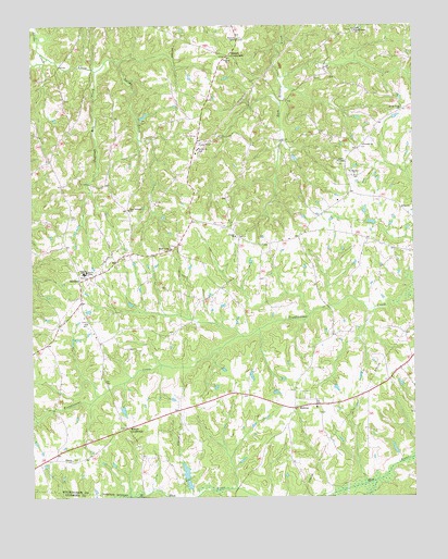
Bethany, NC USGS Topographic Map
Click on map above to begin viewing in our Map Viewer.

This topographic map contains these locations and features:
Feature Name Type Latitude Longitude GNIS ID View Map
Antioch ChurchChurchN36.3432°W79.7661°980248View Map
Bakers CrossroadsPopulated PlaceN36.3671°W79.8098°1018910View Map
BethanyPopulated PlaceN36.3074°W79.8586°1006129View Map
Bethany Volunteer Fire DepartmentBuildingN36.3108°W79.8488°2638348View Map
Canaan ParkPopulated PlaceN36.2762°W79.7850°1005616View Map
Glencoe ChurchChurchN36.2601°W79.8620°985727View Map
Haw River State ParkParkN36.2508°W79.7564°2374755View Map
Howards ChapelChurchN36.3715°W79.8070°987185View Map
Huffines Mill CreekStreamN36.3632°W79.8536°987217View Map
Jones ChapelChurchN36.3393°W79.7742°987740View Map
Little Jacobs CreekStreamN36.3662°W79.8689°988680View Map
Maple Lawn ChurchChurchN36.3157°W79.8292°989311View Map
Mebens LakeReservoirN36.2701°W79.8714°1000446View Map
Mebens Lake DamDamN36.2701°W79.8714°1000445View Map
MidwayPopulated PlaceN36.2735°W79.7889°1006298View Map
Miller ChurchChurchN36.3262°W79.7542°990000View Map
Mountain View AerodromeAirportN36.3391°W79.8242°2679246View Map
New Lebanon ChurchChurchN36.3262°W79.8428°991057View Map
Saint Mariahs ChurchChurchN36.3354°W79.7686°994006View Map
Sandy Cross ChurchChurchN36.3529°W79.7534°994267View Map
Shady Grove ChurchChurchN36.3732°W79.7681°994560View Map
Sharon ChurchChurchN36.3193°W79.8081°994591View Map
Simpsons LakeReservoirN36.2768°W79.8414°1000458View Map
Simpsons Lake DamDamN36.2768°W79.8414°1000457View Map
Smyrna ChurchChurchN36.3662°W79.8100°995033View Map
Walker DamDamN36.2751°W79.8381°1000452View Map
Walker LakeReservoirN36.2751°W79.8381°1000451View Map
Wittys CrossroadsPopulated PlaceN36.2682°W79.8436°1006412View Map

Note: Coordinates in the location and feature list above are referenced to NAD83 datum.


Copyright (C) 2008-2024 Ryan Niemi / Sunset Dynamics ... All Rights Reserved