TopoQuest Logo
Do you find TopoQuest useful?
Help keep TopoQuest running and adding new maps/features by donating!
Bitcoin:  19c7KJd3qBynnjoSw5npx9KScwjBe4ifkT
Litecoin:  LXs6TkuXGGXo1vDsWCkWVdjQX94eUKd6ui
Home View Maps Find Maps Find Places Resources & Links


Reidsville, North Carolina Topographic Map

USGS Map Title: Reidsville, NC
USGS Map MRC: 36079C6
DRG (GeoTIFF) Download: o36079c6.tif


Neighboring USGS Topographic Map Quads:


  Southwest Eden, NC  
36079D7
 

  Southeast Eden, NC  
36079D6
 

  Ruffin, NC  
36079D5
 

  Bethany, NC  
36079C7
 

  Reidsville, NC  
36079C6
 

  Williamsburg, NC  
36079C5
 

  Lake Brandt, NC  
36079B7
 

  Browns Summit, NC  
36079B6
 

  Ossipee, NC  
36079B5


Map MRC Location:

N37°
W80°
N37°
W79°
H8 H7 H6 H5 H4 H3 H2 H1
G8 G7 G6 G5 G4 G3 G2 G1
F8 F7 F6 F5 F4 F3 F2 F1
E8 E7 E6 E5 E4 E3 E2 E1
D8 D7 D6 D5 D4 D3 D2 D1
C8 C7 C6 C5 C4 C3 C2 C1
B8 B7 B6 B5 B4 B3 B2 B1
A8 A7 A6 A5 A4 A3 A2 A1
N36°
W80°
N36°
W79°

Reidsville, NC USGS 1:24K Topographic Map Preview:
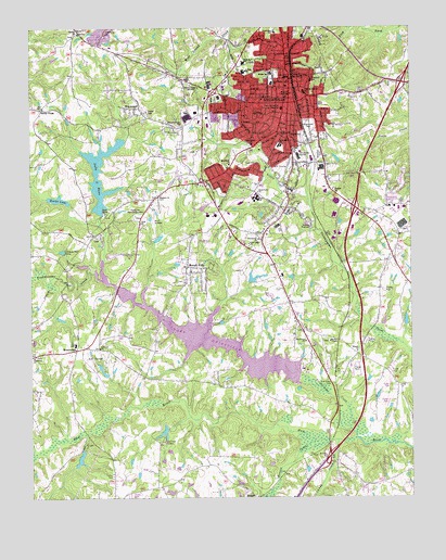
Reidsville, NC USGS Topographic Map
Click on map above to begin viewing in our Map Viewer.

This topographic map contains these locations and features:
Feature Name Type Latitude Longitude GNIS ID View Map
Annie Penn HospitalHospitalN36.3533°W79.6671°1024211View Map
BelmontPopulated PlaceN36.3340°W79.6861°1005577View Map
Benaja ChurchChurchN36.2610°W79.6534°980980View Map
Benaja CreekStreamN36.2649°W79.6573°1019086View Map
Branch Street SchoolSchoolN36.3612°W79.6573°981824View Map
Calvary ChurchChurchN36.3737°W79.7336°982463View Map
CambridgePopulated PlaceN36.3349°W79.6331°1005615View Map
Candy CreekStreamN36.2651°W79.6489°1019506View Map
Chapel Hill ChurchChurchN36.2876°W79.7486°983020View Map
Chinqua-Penn CampLocaleN36.3154°W79.7386°983148View Map
City of ReidsvilleCivilN36.3380°W79.6725°2404605View Map
Clarks LakeReservoirN36.3190°W79.7077°1000517View Map
Clarks Lake DamDamN36.3185°W79.7081°1000516View Map
Colonial EstatesPopulated PlaceN36.2890°W79.6348°1005614View Map
Community ChurchChurchN36.3021°W79.6748°1024794View Map
Courtland ParkPopulated PlaceN36.3471°W79.6798°1005575View Map
Danbury ChurchChurchN36.3304°W79.7075°983937View Map
Eastside ChurchChurchN36.3318°W79.6498°984570View Map
Elm Grove CemeteryCemeteryN36.2804°W79.6506°984743View Map
Elm Grove ChurchChurchN36.2918°W79.6598°984746View Map
Evergreen Memory GardensCemeteryN36.3246°W79.7142°984884View Map
Fairview ChurchChurchN36.2901°W79.7270°984926View Map
Faith ChurchChurchN36.3235°W79.7134°984957View Map
Forest HillsPopulated PlaceN36.3118°W79.6984°985275View Map
FousheePopulated PlaceN36.2929°W79.6536°1023591View Map
Franklin Street SchoolSchoolN36.3604°W79.6700°1024756View Map
Greenview CemeteryCemeteryN36.3482°W79.6575°986118View Map
Guilrock CampLocaleN36.2651°W79.7073°986196View Map
Hester LakeLakeN36.3294°W79.7406°986671View Map
Hesters LakeReservoirN36.3285°W79.7364°1000528View Map
Hesters Lake DamDamN36.3285°W79.7364°1000529View Map
Holy Infant ChurchChurchN36.3174°W79.6778°986989View Map
Holy Trinity ChurchChurchN36.3440°W79.6767°986999View Map
Lake HuntReservoirN36.3257°W79.7259°987247View Map
Lake Hunt DamDamN36.3254°W79.7259°1000524View Map
Lake ReidsvilleReservoirN36.2801°W79.6611°1024774View Map
Lawsonville Avenue SchoolSchoolN36.3576°W79.6592°988233View Map
M & L Memorial Faith TabernacleChurchN36.3716°W79.6577°2630896View Map
Methodist Camp LakeReservoirN36.2675°W79.7063°1000442View Map
Methodist Camp Lake DamDamN36.2685°W79.7048°1000441View Map
Middle SchoolSchoolN36.3629°W79.6703°989797View Map
Mizpah ChurchChurchN36.2890°W79.6428°990112View Map
MonroetonPopulated PlaceN36.2896°W79.7348°990149View Map
Monroeton Elementary SchoolSchoolN36.2910°W79.7350°1007244View Map
Monroeton Volunteer Fire DepartmentBuildingN36.2903°W79.7305°2638455View Map
Moss Street SchoolSchoolN36.3660°W79.6792°1024764View Map
North End SchoolSchoolN36.3737°W79.6689°991219View Map
NorwoodPopulated PlaceN36.3526°W79.7128°991317View Map
Oak HillsPopulated PlaceN36.3115°W79.6903°1005579View Map
Pennrose MallLocaleN36.3404°W79.6614°1007687View Map
Pleasant Grove ChurchChurchN36.3493°W79.7003°992505View Map
Reidlawn CemeteryCemeteryN36.3421°W79.6545°993235View Map
ReidsvillePopulated PlaceN36.3549°W79.6645°1022217View Map
Reidsville Fire DepartmentBuildingN36.3572°W79.6648°2638459View Map
Reidsville Fire Department Station 2BuildingN36.3352°W79.6529°2639687View Map
Reidsville Fire Department Station 3BuildingN36.3362°W79.6950°2639686View Map
Reidsville High SchoolSchoolN36.3296°W79.6753°1007245View Map
Reidsville Junior High SchoolSchoolN36.3282°W79.6823°1007232View Map
Reidsville Middle SchoolSchoolN36.3632°W79.6798°1007246View Map
Reidsville Police DepartmentBuildingN36.3618°W79.6651°2769609View Map
Reidsville Post OfficePost OfficeN36.3558°W79.6630°2773889View Map
Reidsville QuarryMineN36.3739°W79.7250°2649272View Map
Reidsville Rescue SquadBuildingN36.3300°W79.6654°2720346View Map
Reidsville Water Supply DamDamN36.2801°W79.6611°1024775View Map
Sandy CrossPopulated PlaceN36.3535°W79.7456°994266View Map
South End SchoolSchoolN36.3437°W79.6678°995141View Map
South Park ChurchChurchN36.3315°W79.6745°995184View Map
Southwood Village Shopping CenterLocaleN36.3393°W79.6567°1007233View Map
Township of ReidsvilleCivilN36.3520°W79.6422°1027136View Map
Township of SimpsonvilleCivilN36.2907°W79.7468°1027138View Map
TrentwoodPopulated PlaceN36.3368°W79.6784°1005578View Map
Troublesome CreekStreamN36.2660°W79.6431°996266View Map
Warf AirportAirportN36.3274°W79.7099°998060View Map
Washburns LakeReservoirN36.3084°W79.6771°1000498View Map
Washburns Lake DamDamN36.3085°W79.6764°1000499View Map
Wesley ChapelChurchN36.2918°W79.6517°996969View Map
WKXQ-AM (Reidsville)TowerN36.3593°W79.7025°1018562View Map
Womack CourtsPopulated PlaceN36.3504°W79.6831°1005574View Map
Woodland ParkPopulated PlaceN36.3368°W79.6892°1005576View Map
Woodmont ChurchChurchN36.3387°W79.6839°997603View Map

Note: Coordinates in the location and feature list above are referenced to NAD83 datum.


Copyright (C) 2008-2024 Ryan Niemi / Sunset Dynamics ... All Rights Reserved