TopoQuest Logo
Do you find TopoQuest useful?
Help keep TopoQuest running and adding new maps/features by donating!
Bitcoin:  19c7KJd3qBynnjoSw5npx9KScwjBe4ifkT
Litecoin:  LXs6TkuXGGXo1vDsWCkWVdjQX94eUKd6ui
Home View Maps Find Maps Find Places Resources & Links


Pinal Ranch, Arizona Topographic Map

USGS Map Title: Pinal Ranch, AZ
USGS Map MRC: 33110C8
DRG (GeoTIFF) Download: o33110c8.tif


Neighboring USGS Topographic Map Quads:


  Haunted Canyon, AZ  
33111D1
 

  Inspiration, AZ  
33110D8
 

  Globe, AZ  
33110D7
 

  Superior, AZ  
33111C1
 

  Pinal Ranch, AZ  
33110C8
 

  Pinal Peak, AZ  
33110C7
 

  Teapot Mountain, AZ  
33111B1
 

  Hot Tamale Peak, AZ  
33110B8
 

  El Capitan Mountain, AZ  
33110B7


Map MRC Location:

N34°
W111°
N34°
W110°
H8 H7 H6 H5 H4 H3 H2 H1
G8 G7 G6 G5 G4 G3 G2 G1
F8 F7 F6 F5 F4 F3 F2 F1
E8 E7 E6 E5 E4 E3 E2 E1
D8 D7 D6 D5 D4 D3 D2 D1
C8 C7 C6 C5 C4 C3 C2 C1
B8 B7 B6 B5 B4 B3 B2 B1
A8 A7 A6 A5 A4 A3 A2 A1
N33°
W111°
N33°
W110°

Pinal Ranch, AZ USGS 1:24K Topographic Map Preview:
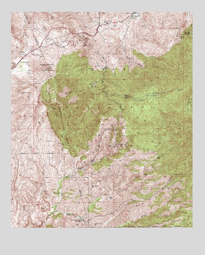
Pinal Ranch, AZ USGS Topographic Map
Click on map above to begin viewing in our Map Viewer.

This topographic map contains these locations and features:
Feature Name Type Latitude Longitude GNIS ID View Map
American MineMineN33.3337°W110.9846°25627View Map
Bee Tree SpringSpringN33.2612°W110.9434°39252View Map
BellevuePopulated PlaceN33.3320°W110.9434°26203View Map
Black RockLocaleN33.3064°W110.9343°39271View Map
Black Rock MineMineN33.3067°W110.9332°26444View Map
Black Rock SpringSpringN33.2742°W110.9454°26445View Map
Burro Water SpringSpringN33.2637°W110.9498°39305View Map
Cameron SpringSpringN33.3098°W110.8923°39314View Map
Captain Trap SpringSpringN33.2520°W110.9434°27281View Map
Cherry Flat CampgroundParkN33.3623°W110.8773°27548View Map
Clark RanchLocaleN33.3512°W110.9918°27682View Map
Copper Springs CanyonValleyN33.3684°W110.9218°27933View Map
Copper Vault TunnelMineN33.2806°W110.9087°27935View Map
Cornwater SpringSpringN33.2842°W110.9532°27963View Map
Cottonwood TankReservoirN33.2903°W110.9201°39384View Map
Coyote SpringSpringN33.3659°W110.9493°39389View Map
Diamond M SpringSpringN33.3553°W110.8996°39408View Map
Dry Lake TankReservoirN33.2659°W110.9146°39423View Map
Dry Wash Mineral CreekStreamN33.2759°W110.9671°28648View Map
Ellis RanchLocaleN33.3245°W110.9118°28880View Map
Elwood SpringSpringN33.3348°W110.9137°39435View Map
Fatty TankReservoirN33.2617°W110.9173°39437View Map
Five Point MountainSummitN33.3423°W110.9746°29035View Map
Gibson MineMineN33.3345°W110.9415°41265View Map
Goatwater SpringSpringN33.2928°W110.9662°40343View Map
Goatwater SpringSpringN33.2981°W110.9634°29365View Map
Government SpringSpringN33.2545°W110.9526°29447View Map
Granite PointSummitN33.3603°W110.8834°29489View Map
Hagen RanchLocaleN33.2539°W110.9521°29679View Map
Hairpin SpringSpringN33.3731°W110.9479°39489View Map
Hale TankReservoirN33.2671°W110.9330°29683View Map
Henderson RanchLocaleN33.3259°W110.9218°29890View Map
Hutton PeakSummitN33.3281°W110.9934°30309View Map
Iron CanyonValleyN33.3053°W110.9643°30410View Map
Iron Canyon SpringSpringN33.3192°W110.9696°30412View Map
Iron Flat TankReservoirN33.3234°W110.9873°40358View Map
Kennedy Pasture SpringSpringN33.2628°W110.9615°40363View Map
Little RanchLocaleN33.3273°W110.8996°31116View Map
Lost Horse SpringSpringN33.3278°W110.9632°31302View Map
Lund Pasture TankReservoirN33.2870°W110.9101°39588View Map
Lunn TankReservoirN33.2910°W110.9003°31404View Map
Lyons CanyonValleyN33.2767°W110.9662°31417View Map
Lyons ForkStreamN33.2598°W110.9704°31418View Map
Lyons Fork SpringSpringN33.2937°W110.9315°39589View Map
M F RanchLocaleN33.3420°W110.9359°31422View Map
Main SpringSpringN33.3656°W110.9063°39591View Map
Mays GapGapN33.2781°W110.9096°39595View Map
Mays Gap WellWellN33.2698°W110.9057°39596View Map
Mead CanyonValleyN33.3556°W110.9465°31691View Map
Melloy SpringSpringN33.2514°W110.8965°39608View Map
Mercer Tunnel SpringSpringN33.3320°W110.9665°39609View Map
Mill Creek WellWellN33.2567°W110.9051°39629View Map
Mine SpringsSpringN33.3673°W110.9091°41917View Map
Mud SpringSpringN33.3003°W110.9754°32102View Map
Needle CreekStreamN33.3739°W110.9148°32266View Map
Oxhide Mine SpringSpringN33.3748°W110.9168°39674View Map
Patterson SpringSpringN33.3081°W110.9337°39679View Map
Patterson SpringSpringN33.3142°W110.9268°39680View Map
Pinal RanchLocaleN33.3478°W110.9934°32911View Map
Pinto TankReservoirN33.3351°W110.9004°39702View Map
Red Point TankReservoirN33.2584°W110.9154°39728View Map
Red Rock MineMineN33.2884°W110.9443°33500View Map
Road TankReservoirN33.2834°W110.8773°39743View Map
Samsel MinesMineN33.2776°W110.8915°34005View Map
Samsel SpringSpringN33.2806°W110.8840°34006View Map
Savage Tunnel SpringSpringN33.3481°W110.9568°39774View Map
Schultze RanchLocaleN33.3742°W110.9162°34158View Map
Signal MountainSummitN33.3445°W110.9993°34420View Map
Simpson LakeReservoirN33.3265°W110.9057°39795View Map
Sixty Six RanchLocaleN33.2701°W110.9659°34479View Map
Stevens GorgeValleyN33.3731°W110.8787°34837View Map
Sulfite MineMineN33.2981°W110.9279°34929View Map
Switchback TankReservoirN33.2523°W110.8904°39824View Map
Sykes SpringSpringN33.2792°W110.8784°39829View Map
Top-of-the-WorldPopulated PlaceN33.3495°W110.9926°1853171View Map
Top-of-the-World Census Designated PlaceCensusN33.3477°W110.9997°2409335View Map
Toro SpringSpringN33.3560°W110.9510°39841View Map
Trap SpringSpringN33.3253°W110.8962°39844View Map
Tunnel SpringSpringN33.2734°W110.8965°39846View Map
Tunnel SpringSpringN33.2626°W110.8957°39847View Map
Twin Tunnel SpringSpringN33.3142°W110.9412°39853View Map
Upper Mud SpringSpringN33.3076°W110.9782°40450View Map
Upper Pinto SpringSpringN33.3342°W110.8790°39857View Map
Warnica SpringsSpringN33.3620°W110.8779°35897View Map

Note: Coordinates in the location and feature list above are referenced to NAD83 datum.


Copyright (C) 2008-2024 Ryan Niemi / Sunset Dynamics ... All Rights Reserved