TopoQuest Logo
Do you find TopoQuest useful?
Help keep TopoQuest running and adding new maps/features by donating!
Bitcoin:  19c7KJd3qBynnjoSw5npx9KScwjBe4ifkT
Litecoin:  LXs6TkuXGGXo1vDsWCkWVdjQX94eUKd6ui
Home View Maps Find Maps Find Places Resources & Links


Pierce, Oklahoma Topographic Map

USGS Map Title: Pierce, OK
USGS Map MRC: 35095D6
DRG (GeoTIFF) Download: o35095d6.tif


Neighboring USGS Topographic Map Quads:


  Morris, OK  
35095E7
 

  Council Hill, OK  
35095E6
 

  Wainwright, OK  
35095E5
 

  Hoffman, OK  
35095D7
 

  Pierce, OK  
35095D6
 

  Checotah, OK  
35095D5
 

  Raiford, OK  
35095C7
 

  Stidham, OK  
35095C6
 

  Eufaula, OK  
35095C5


Map MRC Location:

N36°
W96°
N36°
W95°
H8 H7 H6 H5 H4 H3 H2 H1
G8 G7 G6 G5 G4 G3 G2 G1
F8 F7 F6 F5 F4 F3 F2 F1
E8 E7 E6 E5 E4 E3 E2 E1
D8 D7 D6 D5 D4 D3 D2 D1
C8 C7 C6 C5 C4 C3 C2 C1
B8 B7 B6 B5 B4 B3 B2 B1
A8 A7 A6 A5 A4 A3 A2 A1
N35°
W96°
N35°
W95°

Pierce, OK USGS 1:24K Topographic Map Preview:
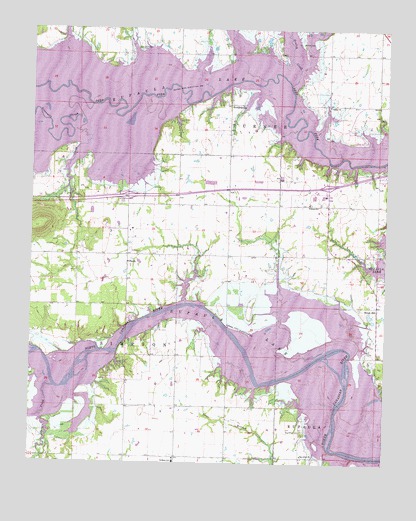
Pierce, OK USGS Topographic Map
Click on map above to begin viewing in our Map Viewer.

This topographic map contains these locations and features:
Feature Name Type Latitude Longitude GNIS ID View Map
Big Arbor CemeteryCemeteryN35.3844°W95.6543°1090082View Map
Big Arbor ChurchChurchN35.3770°W95.6544°1090083View Map
Brush HillPopulated PlaceN35.4201°W95.6283°1100241View Map
Brush Hill CemeteryCemeteryN35.4210°W95.6310°2711809View Map
Fountainhead Area Improvement Council Fire Department Brush StationBuildingN35.4156°W95.6274°2657474View Map
Fountainhead Area Improvement Council Fire Department PierceBuildingN35.4336°W95.7344°2657081View Map
Galilee ChurchChurchN35.4782°W95.6455°1093094View Map
Gentry CreekStreamN35.4843°W95.6597°1093159View Map
Hitchita-Pierce DivisionCivilN35.4626°W95.7340°1937732View Map
Lerblance Cemetery (historical)CemeteryN35.4945°W95.7133°1094587View Map
McNik CemeteryCemeteryN35.4962°W95.6558°1095279View Map
Paradise Point Fire DepartmentBuildingN35.4702°W95.6365°2657063View Map
PiercePopulated PlaceN35.4348°W95.7164°1100737View Map
Pierce CemeteryCemeteryN35.4496°W95.7184°1096624View Map
Pierce High SchoolSchoolN35.4426°W95.7147°1096626View Map
RichardsvillePopulated PlaceN35.4784°W95.6808°1100789View Map
Sevenmile SloughStreamN35.4751°W95.7330°1097929View Map
Sharper CreekStreamN35.3968°W95.7417°1097961View Map
Snake CreekStreamN35.4779°W95.7294°1098147View Map
Stidham SchoolSchoolN35.3754°W95.6992°1098536View Map
Township of TurnerCivilN35.4807°W95.6753°1824634View Map
Vivian Area Fire Protection Association StidhamBuildingN35.3766°W95.6995°2657094View Map
Warrior SchoolSchoolN35.4498°W95.6525°1099380View Map

Note: Coordinates in the location and feature list above are referenced to NAD83 datum.


Copyright (C) 2008-2024 Ryan Niemi / Sunset Dynamics ... All Rights Reserved