TopoQuest Logo
Do you find TopoQuest useful?
Help keep TopoQuest running and adding new maps/features by donating!
Bitcoin:  19c7KJd3qBynnjoSw5npx9KScwjBe4ifkT
Litecoin:  LXs6TkuXGGXo1vDsWCkWVdjQX94eUKd6ui
Home View Maps Find Maps Find Places Resources & Links


Hoffman, Oklahoma Topographic Map

USGS Map Title: Hoffman, OK
USGS Map MRC: 35095D7
DRG (GeoTIFF) Download: o35095d7.tif


Neighboring USGS Topographic Map Quads:


  Okmulgee South, OK  
35095E8
 

  Morris, OK  
35095E7
 

  Council Hill, OK  
35095E6
 

  Henryetta, OK  
35095D8
 

  Hoffman, OK  
35095D7
 

  Pierce, OK  
35095D6
 

  Henryetta SW, OK  
35095C8
 

  Raiford, OK  
35095C7
 

  Stidham, OK  
35095C6


Map MRC Location:

N36°
W96°
N36°
W95°
H8 H7 H6 H5 H4 H3 H2 H1
G8 G7 G6 G5 G4 G3 G2 G1
F8 F7 F6 F5 F4 F3 F2 F1
E8 E7 E6 E5 E4 E3 E2 E1
D8 D7 D6 D5 D4 D3 D2 D1
C8 C7 C6 C5 C4 C3 C2 C1
B8 B7 B6 B5 B4 B3 B2 B1
A8 A7 A6 A5 A4 A3 A2 A1
N35°
W96°
N35°
W95°

Hoffman, OK USGS 1:24K Topographic Map Preview:
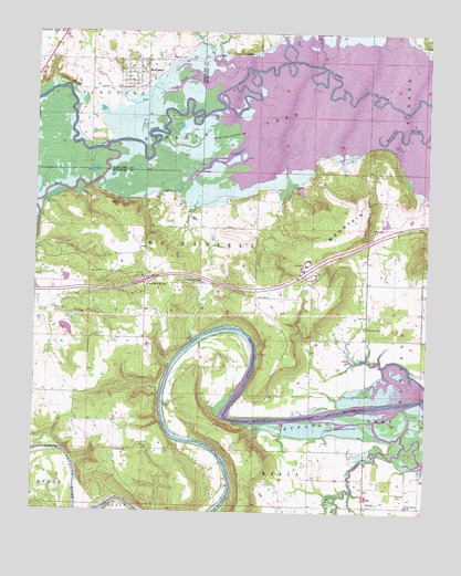
Hoffman, OK USGS Topographic Map
Click on map above to begin viewing in our Map Viewer.

This topographic map contains these locations and features:
Feature Name Type Latitude Longitude GNIS ID View Map
BurneyLocaleN35.4345°W95.8225°1763688View Map
Cat CreekStreamN35.4909°W95.8094°1091032View Map
Cowden LakeReservoirN35.4224°W95.8650°1750969View Map
Cowden Lake DamDamN35.4225°W95.8666°1750968View Map
Eufaula Wildlife Managment AreaReserveN35.4718°W95.8311°1763722View Map
Gar CreekStreamN35.3793°W95.7780°1093103View Map
Grave CreekStreamN35.4918°W95.7853°1093337View Map
Hilltop SchoolSchoolN35.3907°W95.8489°1093791View Map
HoffmanPopulated PlaceN35.4893°W95.8428°1093812View Map
Hoffman CemeteryCemeteryN35.4933°W95.8337°1093813View Map
Hoffman Volunteer Fire DepartmentBuildingN35.4897°W95.8431°2657302View Map
LennaPopulated PlaceN35.3765°W95.7694°1100573View Map
Lenna Post Office (historical)Post OfficeN35.3762°W95.7697°1829086View Map
Limbo CreekStreamN35.4029°W95.7569°1094646View Map
Little Coweta ChurchChurchN35.3768°W95.7555°1094743View Map
Morrison CemeteryCemeteryN35.3800°W95.7593°1095527View Map
Sallisaw Park LakeReservoirN35.4651°W95.8619°1751009View Map
Sallisaw Park Lake DamDamN35.4651°W95.8619°1751008View Map
Silver Spring ChurchChurchN35.4357°W95.8280°1098050View Map
Thompson CemeteryCemeteryN35.4234°W95.7699°1098857View Map
Tiger MountainSummitN35.4495°W95.7750°1098897View Map
Tiger Mountain Rural Fire DepartmentBuildingN35.4320°W95.8406°2657229View Map
Tiger Mountain SchoolSchoolN35.4340°W95.8397°1098898View Map
Town of HoffmanCivilN35.4889°W95.8449°2412759View Map
Township of McDanielsCivilN35.4445°W95.8211°1824633View Map
Wolf CreekStreamN35.4693°W95.8533°1099952View Map

Note: Coordinates in the location and feature list above are referenced to NAD83 datum.


Copyright (C) 2008-2024 Ryan Niemi / Sunset Dynamics ... All Rights Reserved