TopoQuest Logo
Do you find TopoQuest useful?
Help keep TopoQuest running and adding new maps/features by donating!
Bitcoin:  19c7KJd3qBynnjoSw5npx9KScwjBe4ifkT
Litecoin:  LXs6TkuXGGXo1vDsWCkWVdjQX94eUKd6ui
Home View Maps Find Maps Find Places Resources & Links


Pecan Point, Arkansas Topographic Map

USGS Map Title: Pecan Point, AR
USGS Map MRC: 35090D1
DRG (GeoTIFF) Download: o35090d1.tif


Neighboring USGS Topographic Map Quads:


  Joiner, AR  
35090E2
 

  Wilson, AR  
35090E1
 

  Nodena, AR  
35089E8
 

  Frenchmans Bayou, AR  
35090D2
 

  Pecan Point, AR  
35090D1
 

  Drummonds, TN  
35089D8
 

  Jericho, AR  
35090C2
 

  Locke, TN  
35090C1
 

  Millington, TN  
35089C8


Map MRC Location:

N36°
W91°
N36°
W90°
H8 H7 H6 H5 H4 H3 H2 H1
G8 G7 G6 G5 G4 G3 G2 G1
F8 F7 F6 F5 F4 F3 F2 F1
E8 E7 E6 E5 E4 E3 E2 E1
D8 D7 D6 D5 D4 D3 D2 D1
C8 C7 C6 C5 C4 C3 C2 C1
B8 B7 B6 B5 B4 B3 B2 B1
A8 A7 A6 A5 A4 A3 A2 A1
N35°
W91°
N35°
W90°

Pecan Point, AR USGS 1:24K Topographic Map Preview:
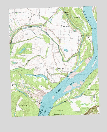
Pecan Point, AR USGS Topographic Map
Click on map above to begin viewing in our Map Viewer.

This topographic map contains these locations and features:
Feature Name Type Latitude Longitude GNIS ID View Map
Andrews LandingLocaleN35.4198°W90.0451°57267View Map
Barrow CemeteryCemeteryN35.4640°W90.0870°1276389View Map
Bateman LandingLocaleN35.3848°W90.0670°1325452View Map
Bend of Island Number Thirty-fiveBendN35.4912°W90.0393°1276997View Map
Black CatPopulated PlaceN35.4651°W90.0245°61995View Map
Black Cat LandingLocaleN35.4662°W90.0229°57384View Map
Brandywine IslandIslandN35.3851°W90.1173°76411View Map
Centennial CutoffChannelN35.3948°W90.0954°1269435View Map
Chute of Island Number Thirty-five RevetmentLeveeN35.4856°W90.0151°1269463View Map
CoronaPopulated PlaceN35.4454°W90.0826°1314893View Map
Corona BarBarN35.3998°W90.0887°1281325View Map
Corona Bar DikesLeveeN35.3962°W90.0756°1310743View Map
Corona LakeLakeN35.4214°W90.0850°1281326View Map
Dean IslandIslandN35.4279°W90.0543°81374View Map
Dean Island BarBarN35.4331°W90.0062°1310744View Map
Dean Island LandingLocaleN35.4243°W90.0395°81375View Map
Dean Island RevetmentCanalN35.4129°W90.0543°79121View Map
Deans IslandPopulated PlaceN35.4284°W90.0412°70085View Map
Densford BarBarN35.4134°W90.0137°1282350View Map
Densford DikesLeveeN35.4112°W90.0270°1310745View Map
Devils Race CourseChannelN35.4001°W90.0598°1644838View Map
Ditch Number 18CanalN35.4887°W90.0937°82114View Map
Ditch Number 19CanalN35.4904°W90.0993°82124View Map
Happy Valley BarBarN35.4262°W90.1043°1286782View Map
Island Number Thirty-sevenFlatN35.4551°W90.0956°1289097View Map
Jacob CemeteryCemeteryN35.4790°W90.0490°50573View Map
Kingsland LandingLocaleN35.4834°W90.0426°77408View Map
Molasses Point LandingLocaleN35.4256°W90.1156°1315530View Map
North LakeLakeN35.4035°W90.1103°75808View Map
Pecan PointPopulated PlaceN35.4776°W90.0393°58340View Map
Pecan Point LandingLocaleN35.4748°W90.0318°58341View Map
Pecan Point-Dean Island DikesLeveeN35.4462°W90.0273°70092View Map
Pumpkin LakeLakeN35.4378°W90.1193°1298680View Map
Random Shot LandingLocaleN35.4923°W90.0465°58460View Map
Saint Francis LeveeLeveeN35.4726°W90.1168°54328View Map
ShawneePopulated PlaceN35.4954°W90.1168°54749View Map
Sunrise ChurchChurchN35.4776°W90.0484°55346View Map
Thweatt ChuteGutN35.4056°W90.0170°1272609View Map
Township of Pecan Point (historical)CivilN35.4751°W90.0501°69667View Map
Union Hill Church (historical)ChurchN35.4667°W90.0301°59398View Map
Walts LandingLocaleN35.3926°W90.0443°1314472View Map

Note: Coordinates in the location and feature list above are referenced to NAD83 datum.


Copyright (C) 2008-2024 Ryan Niemi / Sunset Dynamics ... All Rights Reserved