TopoQuest Logo
Do you find TopoQuest useful?
Help keep TopoQuest running and adding new maps/features by donating!
Bitcoin:  19c7KJd3qBynnjoSw5npx9KScwjBe4ifkT
Litecoin:  LXs6TkuXGGXo1vDsWCkWVdjQX94eUKd6ui
Home View Maps Find Maps Find Places Resources & Links


Paydown, Missouri Topographic Map

USGS Map Title: Paydown, MO
USGS Map MRC: 38091B7
DRG (GeoTIFF) Download: o38091b7.tif


Neighboring USGS Topographic Map Quads:


  Freeburg, MO  
38091C8
 

  Summerfield, MO  
38091C7
 

  Belle, MO  
38091C6
 

  Vienna, MO  
38091B8
 

  Paydown, MO  
38091B7
 

  High Gate, MO  
38091B6
 

  Nagogami Lodge, MO  
38091A8
 

  Vichy, MO  
38091A7
 

  Safe, MO  
38091A6


Map MRC Location:

N39°
W92°
N39°
W91°
H8 H7 H6 H5 H4 H3 H2 H1
G8 G7 G6 G5 G4 G3 G2 G1
F8 F7 F6 F5 F4 F3 F2 F1
E8 E7 E6 E5 E4 E3 E2 E1
D8 D7 D6 D5 D4 D3 D2 D1
C8 C7 C6 C5 C4 C3 C2 C1
B8 B7 B6 B5 B4 B3 B2 B1
A8 A7 A6 A5 A4 A3 A2 A1
N38°
W92°
N38°
W91°

Paydown, MO USGS 1:24K Topographic Map Preview:
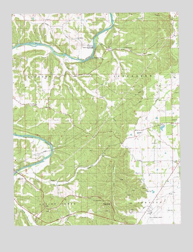
Paydown, MO USGS Topographic Map
Click on map above to begin viewing in our Map Viewer.

This topographic map contains these locations and features:
Feature Name Type Latitude Longitude GNIS ID View Map
BendPopulated PlaceN38.1945°W91.8466°740668View Map
Bend SchoolSchoolN38.1973°W91.8674°713945View Map
Bethel ChurchChurchN38.2467°W91.8496°729998View Map
Boardman CreekStreamN38.2312°W91.8743°714455View Map
Bowles CemeteryCemeteryN38.1873°W91.7513°714578View Map
CairnsLocaleN38.2462°W91.7977°744497View Map
CairnsLocaleN38.2164°W91.8199°744501View Map
Cedar CreekStreamN38.1598°W91.8645°715580View Map
Divins CreekStreamN38.2439°W91.7985°716921View Map
Dover SchoolSchoolN38.1814°W91.7838°717023View Map
Ferrell CemeteryCemeteryN38.1445°W91.7760°717887View Map
Franklin SchoolSchoolN38.2437°W91.8363°718170View Map
Given SpringSpringN38.2354°W91.8268°737950View Map
Givens Mill (historical)LocaleN38.2281°W91.8079°744499View Map
Green CemeteryCemeteryN38.2242°W91.8493°741730View Map
Hallaway HollowValleyN38.2434°W91.7991°737948View Map
Henderson Ford (historical)Populated PlaceN38.1778°W91.8646°740923View Map
Indian House MoundsSummitN38.1639°W91.7796°739168View Map
Indian PaintingsLocaleN38.2359°W91.8138°744498View Map
Indian Village SiteLocaleN38.1675°W91.8338°744502View Map
Johnson CemeteryCemeteryN38.1731°W91.7660°720358View Map
LindellPopulated PlaceN38.1709°W91.7918°735974View Map
Lindell ChurchChurchN38.1728°W91.7938°721098View Map
LoisPopulated PlaceN38.1481°W91.7557°741023View Map
Long CreekStreamN38.2256°W91.8346°721539View Map
Mill Spring CreekStreamN38.2323°W91.8116°722361View Map
Paradise ValleyValleyN38.1598°W91.8649°737951View Map
PaydownPopulated PlaceN38.2289°W91.8038°729601View Map
Paydown ClubLocaleN38.2239°W91.8141°724111View Map
Paydown Ford (historical)Populated PlaceN38.2323°W91.8118°741142View Map
Paydown Gasconade River Public AccessLocaleN38.2300°W91.8143°741729View Map
Paydown Mill (historical)LocaleN38.2292°W91.8046°744500View Map
Paydown SchoolSchoolN38.2173°W91.8110°724112View Map
Paydown SpringsSpringN38.2291°W91.7928°737949View Map
Rolla National AirportAirportN38.1315°W91.7720°758895View Map
Snodgrass CemeteryCemeteryN38.1534°W91.8671°726667View Map
Snodgrass SchoolSchoolN38.1439°W91.8416°726668View Map
Spring Creek Gap Conservation AreaParkN38.1460°W91.8110°2740322View Map
Spring Creek Gap Glades Natural AreaParkN38.1501°W91.8018°2740325View Map
Spring Creek Gap Roadside ParkParkN38.1373°W91.8027°741831View Map
Terrill Clay PitMineN38.1795°W91.7810°727541View Map
Tie SlideSlopeN38.2284°W91.8127°738916View Map
Union Hill CemeteryCemeteryN38.1965°W91.8586°2702441View Map
Union Hill ChurchChurchN38.1967°W91.8588°728022View Map
Vichy Army Air Field (historical)MilitaryN38.1278°W91.7694°2088760View Map
Vichy Gap Filler Annex (historical)MilitaryN38.1356°W91.7733°2088761View Map
Vichy Lookout TowerTowerN38.1395°W91.8096°741731View Map
Walker CemeteryCemeteryN38.1331°W91.7602°728258View Map
Walker SchoolSchoolN38.1464°W91.7643°728265View Map
Wolf CreekStreamN38.2178°W91.8341°729039View Map

Note: Coordinates in the location and feature list above are referenced to NAD83 datum.


Copyright (C) 2008-2024 Ryan Niemi / Sunset Dynamics ... All Rights Reserved