TopoQuest Logo
Do you find TopoQuest useful?
Help keep TopoQuest running and adding new maps/features by donating!
Bitcoin:  19c7KJd3qBynnjoSw5npx9KScwjBe4ifkT
Litecoin:  LXs6TkuXGGXo1vDsWCkWVdjQX94eUKd6ui
Home View Maps Find Maps Find Places Resources & Links


Nagogami Lodge, Missouri Topographic Map

USGS Map Title: Nagogami Lodge, MO
USGS Map MRC: 38091A8
DRG (GeoTIFF) Download: o38091a8.tif


Neighboring USGS Topographic Map Quads:


  Brinktown, MO  
38092B1
 

  Vienna, MO  
38091B8
 

  Paydown, MO  
38091B7
 

  Big Bend, MO  
38092A1
 

  Nagogami Lodge, MO  
38091A8
 

  Vichy, MO  
38091A7
 

  Dixon, MO  
37092H1
 

  Newburg, MO  
37091H8
 

  Rolla, MO  
37091H7


Map MRC Location:

N39°
W92°
N39°
W91°
H8 H7 H6 H5 H4 H3 H2 H1
G8 G7 G6 G5 G4 G3 G2 G1
F8 F7 F6 F5 F4 F3 F2 F1
E8 E7 E6 E5 E4 E3 E2 E1
D8 D7 D6 D5 D4 D3 D2 D1
C8 C7 C6 C5 C4 C3 C2 C1
B8 B7 B6 B5 B4 B3 B2 B1
A8 A7 A6 A5 A4 A3 A2 A1
N38°
W92°
N38°
W91°

Nagogami Lodge, MO USGS 1:24K Topographic Map Preview:
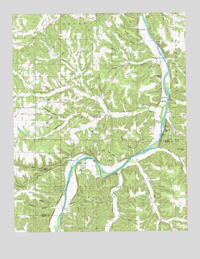
Nagogami Lodge, MO USGS Topographic Map
Click on map above to begin viewing in our Map Viewer.

This topographic map contains these locations and features:
Feature Name Type Latitude Longitude GNIS ID View Map
Apex Lake DamDamN38.1050°W91.9502°765357View Map
Barn HollowValleyN38.0156°W91.9602°713659View Map
Bell BluffCliffN38.0328°W91.9279°737983View Map
Bell Chute Public AccessLocaleN38.0745°W91.8888°741855View Map
Bell SchoolSchoolN38.0564°W91.9329°713917View Map
Big Hill HollowValleyN38.0398°W91.9246°714167View Map
Bliss HollowValleyN38.1087°W91.9052°714370View Map
Bloom HollowValleyN38.0475°W91.8949°714381View Map
Brison HollowValleyN38.0548°W91.8982°714719View Map
Camp CreekStreamN38.0409°W91.9163°749173View Map
Carr RidgeRidgeN38.1162°W91.9218°737981View Map
Cave RidgeRidgeN38.0223°W91.9154°715526View Map
Clifty Creek Natural BridgeArchN38.0367°W91.9758°723130View Map
Clifty HollowValleyN38.0414°W91.9604°715987View Map
Clifty SpringSpringN38.0411°W91.9619°715989View Map
Coldiron HollowValleyN38.0150°W91.9710°729994View Map
Davis CemeteryCemeteryN38.0686°W91.9024°741856View Map
Davis SpringSpringN38.0621°W91.8975°716742View Map
Doyle CreekStreamN38.0795°W91.9482°717037View Map
Dry CreekStreamN38.0834°W91.8918°717091View Map
Duerson SlideCliffN38.0106°W91.9721°717155View Map
East Coyle HollowValleyN38.0984°W91.8877°717267View Map
Fischer HollowValleyN38.0431°W91.9435°737982View Map
Fulkerson CemeteryCemeteryN38.0820°W91.9457°718284View Map
Gaines FerryLocaleN38.0564°W91.8932°718306View Map
Gaines Ford (historical)Populated PlaceN38.0600°W91.8927°740863View Map
Gaines Ford BranchStreamN38.0664°W91.8893°718307View Map
Gaines Ford SpringSpringN38.0598°W91.8910°738922View Map
Granny Baker GraveyardCemeteryN38.0225°W91.9302°744604View Map
HaydenPopulated PlaceN38.0750°W91.9768°740915View Map
Honse CemeteryCemeteryN38.0661°W91.8779°741854View Map
Hughes ChapelChurchN38.1228°W91.9985°755487View Map
Hughes Chapel SchoolSchoolN38.1242°W91.9974°755480View Map
Kenner ChurchChurchN38.0678°W91.9838°741858View Map
Kenner SchoolSchoolN38.0717°W91.9841°720540View Map
Koch Lake DamDamN38.0250°W91.9652°765354View Map
Little Clifty CreekStreamN38.0439°W91.9446°721191View Map
Low GapGapN38.0511°W91.9098°721628View Map
McMinn SchoolSchoolN38.0867°W91.9285°722158View Map
McMinn SpringSpringN38.0878°W91.8932°722159View Map
Mill CreekStreamN38.0061°W91.8894°751075View Map
Miller Lake DamDamN38.0584°W91.9952°765356View Map
Montague CreekStreamN38.0675°W91.9316°717247View Map
Montague HollowValleyN38.0642°W91.9635°722536View Map
Nagogami LodgeLocaleN38.0573°W91.8913°723108View Map
Nares HollowValleyN38.0442°W91.9127°723118View Map
Parker HollowValleyN38.0975°W91.9182°724035View Map
Parker SpringSpringN38.0992°W91.8957°724038View Map
Pemberty SpringSpringN38.1164°W91.9104°724188View Map
Prewett SchoolSchoolN38.0187°W91.9268°729618View Map
Prewitt CemeteryCemeteryN38.0303°W91.9019°2724061View Map
Ramsey CemeteryCemeteryN38.0578°W91.9424°741857View Map
Spencer StoreLocaleN38.1014°W91.8782°726855View Map
StickneyPopulated PlaceN38.0675°W91.9354°741291View Map
Sweetwater CreekStreamN38.1064°W91.8966°727387View Map
Thox RockIslandN38.0409°W91.9413°737985View Map
Thox RockLocaleN38.0389°W91.9529°730018View Map
Tick CreekStreamN38.0356°W91.9232°752543View Map
Township of Dry CreekCivilN38.0626°W91.9846°766993View Map
Turkey CreekStreamN38.1239°W91.9066°727843View Map
West Coyle HollowValleyN38.0975°W91.8966°728544View Map
Wilson Lake DamDamN38.0550°W91.9902°765355View Map

Note: Coordinates in the location and feature list above are referenced to NAD83 datum.


Copyright (C) 2008-2024 Ryan Niemi / Sunset Dynamics ... All Rights Reserved