TopoQuest Logo
Do you find TopoQuest useful?
Help keep TopoQuest running and adding new maps/features by donating!
Bitcoin:  19c7KJd3qBynnjoSw5npx9KScwjBe4ifkT
Litecoin:  LXs6TkuXGGXo1vDsWCkWVdjQX94eUKd6ui
Home View Maps Find Maps Find Places Resources & Links


Paulding, Ohio Topographic Map

USGS Map Title: Paulding, OH
USGS Map MRC: 41084B5
DRG (GeoTIFF) Download: o41084b5.tif


Neighboring USGS Topographic Map Quads:


  Mark Center, OH  
41084C6
 

  Sherwood, OH  
41084C5
 

  Defiance West, OH  
41084C4
 

  Antwerp, OH  
41084B6
 

  Paulding, OH  
41084B5
 

  Junction, OH  
41084B4
 

  Payne, OH  
41084A6
 

  Latty, OH  
41084A5
 

  Oakwood, OH  
41084A4


Map MRC Location:

N42°
W85°
N42°
W84°
H8 H7 H6 H5 H4 H3 H2 H1
G8 G7 G6 G5 G4 G3 G2 G1
F8 F7 F6 F5 F4 F3 F2 F1
E8 E7 E6 E5 E4 E3 E2 E1
D8 D7 D6 D5 D4 D3 D2 D1
C8 C7 C6 C5 C4 C3 C2 C1
B8 B7 B6 B5 B4 B3 B2 B1
A8 A7 A6 A5 A4 A3 A2 A1
N41°
W85°
N41°
W84°

Paulding, OH USGS 1:24K Topographic Map Preview:
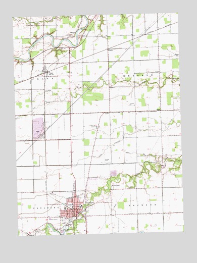
Paulding, OH USGS Topographic Map
Click on map above to begin viewing in our Map Viewer.

This topographic map contains these locations and features:
Feature Name Type Latitude Longitude GNIS ID View Map
Ankney CemeteryCemeteryN41.1850°W84.5238°1037429View Map
Big RunStreamN41.1292°W84.6036°1038033View Map
Black Swamp Nature CenterParkN41.1278°W84.5905°1960995View Map
Buhlert School (historical)SchoolN41.2378°W84.5152°1053324View Map
Bull CreekStreamN41.2034°W84.5911°1038508View Map
CecilPopulated PlaceN41.2187°W84.6022°1038883View Map
Cecil Community GrangeBuildingN41.2145°W84.6019°1960999View Map
Cecil Community ParkParkN41.2212°W84.6033°1961000View Map
Cecil Post OfficePost OfficeN41.2181°W84.6022°1961001View Map
Colters Mobile Home ParkPopulated PlaceN41.1464°W84.5794°2652044View Map
County Home CemeteryCemeteryN41.1503°W84.5541°1961004View Map
Crane Township Cecil Fire DepartmentBuildingN41.2198°W84.6034°2549668View Map
Crane Township HallBuildingN41.2200°W84.6025°1961005View Map
Dupre School (historical)SchoolN41.1789°W84.5930°1053333View Map
Eaton CemeteryCemeteryN41.2403°W84.5783°1040044View Map
Eaton Childrens HomeBuildingN41.2375°W84.5838°1040045View Map
Emerald Forest FarmLocaleN41.1894°W84.5519°2567340View Map
Emerald MissionChurchN41.1945°W84.5152°1040187View Map
Emerald Township HallBuildingN41.2164°W84.5158°1961006View Map
EmmettPopulated PlaceN41.2303°W84.5538°1064621View Map
Emmett Post Office (historical)Post OfficeN41.2306°W84.5541°2041919View Map
Exleben School (historical)SchoolN41.1937°W84.6127°1053332View Map
Goyings School (historical)SchoolN41.1650°W84.5694°1053329View Map
Immaculate Conception CemeteryCemeteryN41.2325°W84.5905°1961016View Map
Kinzer CemeteryCemeteryN41.2017°W84.5049°1042296View Map
LaFountain ParkParkN41.1445°W84.5769°1961020View Map
Lambert School (historical)SchoolN41.1506°W84.5161°1053325View Map
Live Oak CemeteryCemeteryN41.1423°W84.5747°1961025View Map
Moss RunStreamN41.1662°W84.5127°1043513View Map
New RochesterPopulated PlaceN41.2298°W84.6022°1061816View Map
New Rochester ParkParkN41.2320°W84.5944°1961036View Map
Opossum RunStreamN41.1484°W84.5658°1044184View Map
PauldingPopulated PlaceN41.1381°W84.5805°1044331View Map
Paulding Airport IncAirportN41.1721°W84.5554°1082943View Map
Paulding Athletic FieldParkN41.1459°W84.5769°1961043View Map
Paulding County Carnegie Public LibraryBuildingN41.1362°W84.5791°1961044View Map
Paulding County CourthouseBuildingN41.1378°W84.5802°1053838View Map
Paulding County FairgroundsLocaleN41.1306°W84.5847°1961045View Map
Paulding County HomeBuildingN41.1525°W84.5530°1053330View Map
Paulding County HospitalHospitalN41.1343°W84.6011°1961046View Map
Paulding Elementary SchoolSchoolN41.1403°W84.5777°1053837View Map
Paulding Emergency Medical ServicesBuildingN41.1367°W84.5798°2550884View Map
Paulding Fire DepartmentBuildingN41.1418°W84.5836°2549670View Map
Paulding Grange HallBuildingN41.1284°W84.6116°1961047View Map
Paulding High SchoolSchoolN41.1412°W84.5769°1053836View Map
Paulding Memorial CemeteryCemeteryN41.1639°W84.5686°1961048View Map
Paulding Police DepartmentBuildingN41.1367°W84.5797°2732545View Map
Paulding Post OfficePost OfficeN41.1381°W84.5816°1082297View Map
Paulding QuarryMineN41.1861°W84.6142°2567532View Map
Pine View FarmLocaleN41.1261°W84.5369°2567339View Map
Pleasant Grove CemeteryCemeteryN41.1506°W84.5391°1044529View Map
Powers School (historical)SchoolN41.1792°W84.5436°1053328View Map
Reid Post Office (historical)Post OfficeN41.1945°W84.5541°2041515View Map
Reids (historical)Populated PlaceN41.1942°W84.5536°1063329View Map
Rochester CemeteryCemeteryN41.2314°W84.5913°1045106View Map
School Number 10 (historical)SchoolN41.2120°W84.5833°1068244View Map
School Number 3 (historical)SchoolN41.1445°W84.5538°1053331View Map
School Number 5 (historical)SchoolN41.2373°W84.5533°1053326View Map
Scott School (historical)SchoolN41.2084°W84.5480°1053327View Map
Sixmile ChurchChurchN41.2081°W84.5533°1046311View Map
Sixmile CutoffCanalN41.2178°W84.6122°1046312View Map
Township CemeteryCemeteryN41.1981°W84.5388°1047115View Map
Township of EmeraldCivilN41.2107°W84.5211°1086772View Map
Upthegrove CemeteryCemeteryN41.1649°W84.5239°1047379View Map
Village of CecilCivilN41.2191°W84.6017°2397578View Map
Village of PauldingCivilN41.1424°W84.5824°2399632View Map

Note: Coordinates in the location and feature list above are referenced to NAD83 datum.


Copyright (C) 2008-2024 Ryan Niemi / Sunset Dynamics ... All Rights Reserved