TopoQuest Logo
Do you find TopoQuest useful?
Help keep TopoQuest running and adding new maps/features by donating!
Bitcoin:  19c7KJd3qBynnjoSw5npx9KScwjBe4ifkT
Litecoin:  LXs6TkuXGGXo1vDsWCkWVdjQX94eUKd6ui
Home View Maps Find Maps Find Places Resources & Links


Pall Mall, Tennessee Topographic Map

USGS Map Title: Pall Mall, TN
USGS Map MRC: 36084E8
DRG (GeoTIFF) Download: o36084e8.tif


Neighboring USGS Topographic Map Quads:


  Savage, KY  
36085F1
 

  Powersburg, KY  
36084F8
 

  Parmleysville, KY  
36084F7
 

  Moodyville, TN  
36085E1
 

  Pall Mall, TN  
36084E8
 

  Sharp Place, TN  
36084E7
 

  Riverton, TN  
36085D1
 

  Jamestown, TN  
36084D8
 

  Stockton, TN  
36084D7


Map MRC Location:

N37°
W85°
N37°
W84°
H8 H7 H6 H5 H4 H3 H2 H1
G8 G7 G6 G5 G4 G3 G2 G1
F8 F7 F6 F5 F4 F3 F2 F1
E8 E7 E6 E5 E4 E3 E2 E1
D8 D7 D6 D5 D4 D3 D2 D1
C8 C7 C6 C5 C4 C3 C2 C1
B8 B7 B6 B5 B4 B3 B2 B1
A8 A7 A6 A5 A4 A3 A2 A1
N36°
W85°
N36°
W84°

Pall Mall, TN USGS 1:24K Topographic Map Preview:
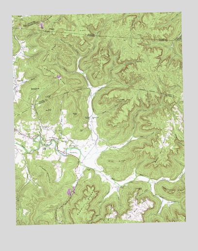
Pall Mall, TN USGS Topographic Map
Click on map above to begin viewing in our Map Viewer.

This topographic map contains these locations and features:
Feature Name Type Latitude Longitude GNIS ID View Map
Arion MountainSummitN36.5691°W84.9717°1275848View Map
Bald RockSummitN36.6187°W84.9891°510368View Map
Baylor KnobSummitN36.5651°W84.9533°1276519View Map
Big Dry CreekStreamN36.5242°W84.9263°1277290View Map
Black House MountainSummitN36.5461°W84.8891°1277580View Map
Blue RidgeRidgeN36.5365°W84.9241°1277772View Map
Brooks CreekStreamN36.5651°W84.9419°1309760View Map
Brooks HollowValleyN36.5647°W84.9422°1278487View Map
Brooks HollowValleyN36.5648°W84.9419°1641028View Map
Brown ChapelChurchN36.5620°W84.9444°1641723View Map
Brown ChapelChurchN36.5634°W84.9444°1305441View Map
Buckey Lick CreekStreamN36.5995°W84.9494°1641089View Map
Buckeye Lick CreekStreamN36.5990°W84.9494°1278862View Map
Bud CreekStreamN36.5515°W84.9127°1278894View Map
Bud CreekStreamN36.5515°W84.9133°1641741View Map
Chestnut FlatsFlatN36.6151°W84.9499°511330View Map
Commissioner District 3CivilN36.5846°W84.9461°2464186View Map
Crabtree BranchStreamN36.5828°W84.9980°1641094View Map
Crabtree BranchStreamN36.5823°W84.9974°1281525View Map
Delk CreekStreamN36.5262°W84.9008°1282319View Map
Dry Hollow CreekStreamN36.6244°W84.9622°2568795View Map
Fallen Water CreekStreamN36.5990°W84.9494°1284088View Map
Fallen Water CreekStreamN36.5887°W84.9466°512122View Map
Fentress County Volunteer Fire Department Station 6 Pall MallBuildingN36.5429°W84.9628°2654917View Map
Fentress County Volunteer Fire Department Station 6 Pall Mall SubstationBuildingN36.5521°W84.9899°2654692View Map
Fentress HillSummitN36.6171°W84.9397°2568799View Map
Fitzgerald KnobSummitN36.6250°W84.9967°2568800View Map
Flat Rock RidgeRidgeN36.5056°W84.9119°1284419View Map
ForbusPopulated PlaceN36.5528°W84.9916°1284558View Map
Forbus School (historical)SchoolN36.5526°W84.9877°1320836View Map
Frogg MountainSummitN36.5473°W84.9772°1641737View Map
Frogge ChapelChurchN36.5465°W84.9766°1641101View Map
Frogge ChapelLocaleN36.5459°W84.9772°1284971View Map
Frogge Chapel CemeteryCemeteryN36.5462°W84.9763°1320837View Map
Frogge MountainSummitN36.5292°W84.9761°1284972View Map
Goodman RidgeRidgeN36.5892°W84.9674°1285647View Map
Grapevine HollowValleyN36.5195°W84.9008°1641084View Map
Grapevine HollowValleyN36.5193°W84.9004°1285864View Map
Greer ChapelChurchN36.5562°W84.9997°1641097View Map
Greer ChapelChurchN36.5559°W84.9997°1286222View Map
Greer Chapel CemeteryCemeteryN36.5562°W84.9980°1320838View Map
Honey Spring MountainSummitN36.5809°W84.9874°1288207View Map
Horseshoe CliffCliffN36.5726°W84.9238°1288442View Map
Huckleberry RidgeRidgeN36.6228°W84.9719°512829View Map
Jane PointSummitN36.5181°W84.9111°1641085View Map
Jane PointCliffN36.5201°W84.9091°1289294View Map
Jesse CreekStreamN36.5142°W84.8916°1289416View Map
Jim CreekStreamN36.5515°W84.9130°1289432View Map
Leffew MineMineN36.5426°W84.9636°1309742View Map
Leffew MineMineN36.5681°W84.9233°1309761View Map
Little Dry CreekStreamN36.5215°W84.9238°1641081View Map
Little Dry CreekStreamN36.5228°W84.9238°1291479View Map
Little Jack CreekStreamN36.5423°W84.9399°1291546View Map
Little Jack CreekStreamN36.5417°W84.9513°1641740View Map
Lynch PinnaclePillarN36.5762°W84.9722°1292341View Map
Lynch PinnacleSummitN36.5762°W84.9722°1641092View Map
Pall MallPopulated PlaceN36.5506°W84.9677°1296688View Map
Pall Mall Post OfficePost OfficeN36.5417°W84.9584°1650072View Map
Pogue CreekStreamN36.5259°W84.9008°1269866View Map
Reed CreekStreamN36.5440°W84.9911°1299141View Map
Reed Creek CemeteryCemeteryN36.5281°W84.9874°1320848View Map
Rocky CreekStreamN36.5898°W84.9488°1641091View Map
Rocky CreekStreamN36.5895°W84.9483°1299881View Map
Rotten Fork SchoolSchoolN36.5631°W84.9436°1300143View Map
Rotten Fork SchoolSchoolN36.5617°W84.9436°1641724View Map
Rotten Fork Wolf RiverStreamN36.5420°W84.9508°1300144View Map
Rotten Fork Wolf RiverStreamN36.5495°W84.9405°1641719View Map
SandcliftPopulated PlaceN36.6242°W84.9911°515232View Map
Sandclift Post Office (historical)Post OfficeN36.6247°W84.9882°2568879View Map
Sawmill RidgeRidgeN36.5115°W84.9491°1300846View Map
Sergeant Alvin York Mill State Historic AreaParkN36.5423°W84.9666°1647212View Map
Shellotte BranchStreamN36.5495°W84.9802°1270007View Map
Shellotte BranchStreamN36.5495°W84.9791°1641734View Map
Short Horn CreekStreamN36.5484°W84.9691°1641729View Map
Short Horn CreekStreamN36.5481°W84.9688°1270205View Map
Slippery RockSummitN36.6165°W84.9669°515492View Map
Spruce Pin HollowValleyN36.6244°W84.9620°2568707View Map
Statehouse RidgeRidgeN36.5184°W84.8830°1271276View Map
Steve Pile MountainSummitN36.5015°W84.9319°1271348View Map
Stewart CreekStreamN36.5120°W84.8872°1303839View Map
Stokes CreekStreamN36.5753°W84.9424°517558View Map
Tater HillSummitN36.5556°W84.9517°1272163View Map
TravisvillePopulated PlaceN36.5845°W84.9938°1314417View Map
Travisville CemeteryCemeteryN36.5809°W84.9966°1320859View Map
Travisville ChurchChurchN36.5801°W84.9988°1641093View Map
Travisville ChurchChurchN36.5798°W84.9986°1304156View Map
Travisville School (historical)SchoolN36.5884°W84.9977°1320180View Map
Upchurch CemeteryCemeteryN36.5576°W84.9783°1320853View Map
Upchurch ChurchChurchN36.5573°W84.9774°1641727View Map
Upchurch ChurchChurchN36.5570°W84.9772°1273285View Map
Watson RidgeRidgeN36.6023°W84.9713°1273934View Map
Wayne Trace RidgeRidgeN36.5973°W84.9338°1273959View Map
Williams CreekStreamN36.5298°W84.8761°1274696View Map
Wolf RiverLocaleN36.5417°W84.9597°1274978View Map
Wolf RiverPopulated PlaceN36.5417°W84.9602°1641739View Map
Wolf River CemeteryCemeteryN36.5473°W84.9541°1320857View Map
Wolf River ChurchChurchN36.5465°W84.9549°1304648View Map
Wolf River ChurchChurchN36.5467°W84.9547°1641730View Map
York Bible SchoolSchoolN36.5492°W84.9611°1641720View Map
York Bible SchoolSchoolN36.5490°W84.9611°1304707View Map
York ChapelChurchN36.5506°W84.9699°1275308View Map
York ChapelChurchN36.5509°W84.9699°1641726View Map

Note: Coordinates in the location and feature list above are referenced to NAD83 datum.


Copyright (C) 2008-2024 Ryan Niemi / Sunset Dynamics ... All Rights Reserved