TopoQuest Logo
Do you find TopoQuest useful?
Help keep TopoQuest running and adding new maps/features by donating!
Bitcoin:  19c7KJd3qBynnjoSw5npx9KScwjBe4ifkT
Litecoin:  LXs6TkuXGGXo1vDsWCkWVdjQX94eUKd6ui
Home View Maps Find Maps Find Places Resources & Links


Moodyville, Tennessee Topographic Map

USGS Map Title: Moodyville, TN
USGS Map MRC: 36085E1
DRG (GeoTIFF) Download: o36085e1.tif


Neighboring USGS Topographic Map Quads:


  Albany, KY  
36085F2
 

  Savage, KY  
36085F1
 

  Powersburg, KY  
36084F8
 

  Byrdstown, TN  
36085E2
 

  Moodyville, TN  
36085E1
 

  Pall Mall, TN  
36084E8
 

  Alpine, TN  
36085D2
 

  Riverton, TN  
36085D1
 

  Jamestown, TN  
36084D8


Map MRC Location:

N37°
W86°
N37°
W85°
H8 H7 H6 H5 H4 H3 H2 H1
G8 G7 G6 G5 G4 G3 G2 G1
F8 F7 F6 F5 F4 F3 F2 F1
E8 E7 E6 E5 E4 E3 E2 E1
D8 D7 D6 D5 D4 D3 D2 D1
C8 C7 C6 C5 C4 C3 C2 C1
B8 B7 B6 B5 B4 B3 B2 B1
A8 A7 A6 A5 A4 A3 A2 A1
N36°
W86°
N36°
W85°

Moodyville, TN USGS 1:24K Topographic Map Preview:
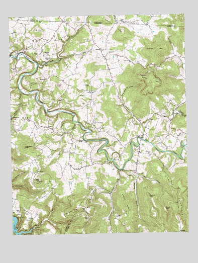
Moodyville, TN USGS Topographic Map
Click on map above to begin viewing in our Map Viewer.

This topographic map contains these locations and features:
Feature Name Type Latitude Longitude GNIS ID View Map
Adkins RidgeRidgeN36.5167°W85.0444°1275488View Map
Amonette CemeteryCemeteryN36.5084°W85.1133°1275665View Map
Amonette CemeteryCemeteryN36.5120°W85.1136°1275666View Map
AsburyPopulated PlaceN36.5815°W85.0666°1314605View Map
Asbury ChapelChurchN36.5823°W85.0666°1309702View Map
Back CreekStreamN36.5317°W85.0374°1304908View Map
Back Creek School (historical)SchoolN36.5281°W85.0194°1650071View Map
Backbone FordCrossingN36.5981°W85.1155°1309704View Map
Beatty Mill (historical)LocaleN36.5528°W85.0572°1309706View Map
Begley BranchStreamN36.5712°W85.0994°1276885View Map
Boiling SpringSpringN36.6207°W85.0378°487627View Map
Buck MountainSummitN36.5173°W85.0047°1269392View Map
Campbell CemeteryCemeteryN36.6012°W85.0599°1279445View Map
Caney CreekStreamN36.5467°W85.0169°1327816View Map
Cedar GrovePopulated PlaceN36.5573°W85.0561°1280030View Map
Cedar Hill School (historical)SchoolN36.5584°W85.0572°1309708View Map
ChanutePopulated PlaceN36.6059°W85.0597°1314818View Map
Chanute School (historical)SchoolN36.6059°W85.0597°1320174View Map
Chapman BranchStreamN36.5367°W85.0458°1305858View Map
Clark CemeteryCemeteryN36.5487°W85.0963°1280602View Map
Clark School (historical)SchoolN36.5123°W85.1211°1647209View Map
Commissioner District 1CivilN36.5260°W85.1133°2464274View Map
Conley Crossroads (historical)Populated PlaceN36.5942°W85.0541°1309709View Map
Cooks Mill (historical)LocaleN36.5226°W85.0547°1650060View Map
DavidsonPopulated PlaceN36.5681°W85.0224°1314932View Map
Davidson CemeteryCemeteryN36.5676°W85.0147°1282102View Map
Davidson School (historical)SchoolN36.5667°W85.0222°1650028View Map
Delk CemeteryCemeteryN36.5553°W85.0049°1282318View Map
Double Top MountainSummitN36.5140°W85.0788°1282711View Map
Dry CreekStreamN36.5365°W85.0477°1282945View Map
Dry Creek School (historical)SchoolN36.5156°W85.0536°1650061View Map
Duncan SinkBasinN36.5134°W85.0163°1283173View Map
Edgefield ChurchChurchN36.6034°W85.0975°1283514View Map
EtterPopulated PlaceN36.5615°W85.0980°1283873View Map
Etter Baptist ChurchChurchN36.5615°W85.1008°1643359View Map
Etter School (historical)SchoolN36.5623°W85.1011°1320175View Map
Fairview CemeteryCemeteryN36.5003°W85.0066°1320832View Map
Falling Waters HollowValleyN36.5780°W85.0460°1284099View Map
Flowers CemeteryCemeteryN36.5953°W85.1211°1284515View Map
Flowers-Zachary CemeteryCemeteryN36.5862°W85.1108°1284517View Map
Franklin CreekStreamN36.5028°W85.1241°1284830View Map
Garrett CemeteryCemeteryN36.6037°W85.1049°1285196View Map
Gilreath MillPopulated PlaceN36.5545°W85.0324°1315114View Map
Golman MountainSummitN36.5881°W85.0230°1285599View Map
Hildreth KnobSummitN36.6173°W85.1050°1287774View Map
Holbert CreekStreamN36.5540°W85.0311°1288022View Map
Huddleston CemeteryCemeteryN36.5751°W85.1202°1288606View Map
Huddleston KnobSummitN36.5506°W85.1152°1288607View Map
Lick CreekStreamN36.5973°W85.1050°496486View Map
Littoral MountainSummitN36.6048°W85.0213°1291726View Map
MoodyvillePopulated PlaceN36.5381°W85.0752°1294218View Map
Moodyville Baptist ChurchChurchN36.5381°W85.0752°1643362View Map
Moodyville School (historical)SchoolN36.5384°W85.0755°1320177View Map
Mount AiryPopulated PlaceN36.5467°W85.0838°1315543View Map
Mount UnionPopulated PlaceN36.5365°W85.1063°1294814View Map
Mount Union School (historical)SchoolN36.5387°W85.1052°1309723View Map
Mullins CemeteryCemeteryN36.6014°W85.0974°1295085View Map
Mullins CemeteryCemeteryN36.6037°W85.1249°1295086View Map
OkraPopulated PlaceN36.6159°W85.1219°1315643View Map
Paggett CemeteryCemeteryN36.5134°W85.1208°1296651View Map
ParkerPopulated PlaceN36.5892°W85.1000°1296790View Map
Parker School (historical)SchoolN36.5890°W85.1002°1309725View Map
Pickett CountyCivilN36.5584°W85.0750°1648580View Map
Piles BranchStreamN36.5962°W85.0013°1297465View Map
Poore CemeteryCemeteryN36.5453°W85.0274°1298149View Map
Poore CemeteryCemeteryN36.5748°W85.0716°1298150View Map
Poore KnobSummitN36.5845°W85.0905°1298151View Map
Porter Poole Mill (historical)LocaleN36.5765°W85.0722°1309731View Map
Pulse CemeteryCemeteryN36.5331°W85.0422°1298667View Map
Pulse Mill (historical)LocaleN36.5365°W85.0458°1650058View Map
Rains Store (historical)LocaleN36.5395°W85.0541°1309733View Map
Reagan and Gibson MineMineN36.5056°W85.0686°1309741View Map
Rector CemeteryCemeteryN36.6226°W85.1024°501639View Map
Rector CemeteryCemeteryN36.6226°W85.1030°1299033View Map
Red HillPopulated PlaceN36.5462°W85.0341°1315792View Map
Red HillPopulated PlaceN36.6112°W85.0963°1647210View Map
Red Hill ChurchChurchN36.6112°W85.0977°1299065View Map
Red Hill Methodist ChurchChurchN36.5456°W85.0347°1320847View Map
Red Hill School (historical)SchoolN36.6101°W85.0861°1309734View Map
Red Hill School (historical)SchoolN36.5467°W85.0338°1650057View Map
Regan KnobSummitN36.5306°W85.1055°1299196View Map
Rich CemeteryCemeteryN36.5217°W85.1030°1299307View Map
Riley CemeteryCemeteryN36.5664°W85.1124°1299454View Map
Riley FordCrossingN36.5487°W85.0033°1650056View Map
Riley MountainSummitN36.5626°W85.0044°1326974View Map
Russell CemeteryCemeteryN36.6223°W85.0444°502505View Map
Russell RidgeRidgeN36.6187°W85.0483°502530View Map
Scotch-Rich CemeteryCemeteryN36.5606°W85.1202°1300917View Map
Scroggins CemeteryCemeteryN36.5098°W85.0513°1300976View Map
Shadow CemeteryCemeteryN36.5356°W85.0361°1301151View Map
Sinking Spring Church (historical)ChurchN36.5351°W85.0366°1650059View Map
Smith CemeteryCemeteryN36.5989°W85.0399°1270655View Map
South FordCrossingN36.5631°W85.0755°1309738View Map
South Lick Creek BranchStreamN36.6009°W85.0886°1270900View Map
StaticPopulated PlaceN36.6217°W85.0861°1271280View Map
StaticPopulated PlaceN36.6220°W85.0850°504285View Map
Static Division (historical)CensusN36.5928°W85.0583°1648910View Map
Step GapGapN36.5095°W85.0713°1271325View Map
Stephens CemeteryCemeteryN36.5339°W85.0358°1271335View Map
Stephens PointCliffN36.5223°W85.0283°1271341View Map
Sulphur SpringsPopulated PlaceN36.5634°W85.0669°1303925View Map
Town BranchStreamN36.5834°W85.1180°1272799View Map
Travis CemeteryCemeteryN36.6214°W85.0469°505477View Map
United ChurchChurchN36.6115°W85.1052°1273265View Map
Upchurch CemeteryCemeteryN36.5456°W85.0272°1273284View Map
Widow CreekStreamN36.5645°W85.0797°1274513View Map
Williams SchoolSchoolN36.5853°W85.0688°1274714View Map
Wright BranchStreamN36.5642°W85.0786°1304685View Map
Wright CemeteryCemeteryN36.5145°W85.0727°1275174View Map

Note: Coordinates in the location and feature list above are referenced to NAD83 datum.


Copyright (C) 2008-2024 Ryan Niemi / Sunset Dynamics ... All Rights Reserved