TopoQuest Logo
Do you find TopoQuest useful?
Help keep TopoQuest running and adding new maps/features by donating!
Bitcoin:  19c7KJd3qBynnjoSw5npx9KScwjBe4ifkT
Litecoin:  LXs6TkuXGGXo1vDsWCkWVdjQX94eUKd6ui
Home View Maps Find Maps Find Places Resources & Links


Pagoda, Colorado Topographic Map

USGS Map Title: Pagoda, CO
USGS Map MRC: 40107C4
DRG (GeoTIFF) Download: o40107c4.tif


Neighboring USGS Topographic Map Quads:


  Castor Gulch, CO  
40107D5
 

  Breeze Mountain, CO  
40107D4
 

  Hayden, CO  
40107D3
 

  Hamilton, CO  
40107C5
 

  Pagoda, CO  
40107C4
 

  Hayden Gulch, CO  
40107C3
 

  Sleepy Cat Peak, CO  
40107B5
 

  Slide Creek, CO  
40107B4
 

  Pagoda Peak, CO  
40107B3


Map MRC Location:

N41°
W108°
N41°
W107°
H8 H7 H6 H5 H4 H3 H2 H1
G8 G7 G6 G5 G4 G3 G2 G1
F8 F7 F6 F5 F4 F3 F2 F1
E8 E7 E6 E5 E4 E3 E2 E1
D8 D7 D6 D5 D4 D3 D2 D1
C8 C7 C6 C5 C4 C3 C2 C1
B8 B7 B6 B5 B4 B3 B2 B1
A8 A7 A6 A5 A4 A3 A2 A1
N40°
W108°
N40°
W107°

Pagoda, CO USGS 1:24K Topographic Map Preview:
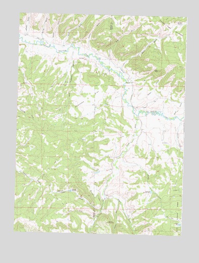
Pagoda, CO USGS Topographic Map
Click on map above to begin viewing in our Map Viewer.

This topographic map contains these locations and features:
Feature Name Type Latitude Longitude GNIS ID View Map
Beaver CreekStreamN40.2728°W107.4342°171497View Map
Bennett ReservoirReservoirN40.3705°W107.3785°171481View Map
Berry GulchValleyN40.3428°W107.4244°171447View Map
Breeze Mountain MineMineN40.3333°W107.4173°1735421View Map
Buckner - Hart CemeteryCemeteryN40.3228°W107.4067°2400529View Map
Butler CreekStreamN40.2936°W107.4231°171444View Map
Cedar CreekStreamN40.2630°W107.4356°171490View Map
Cedar Creek MineMineN40.2733°W107.4684°171478View Map
Coal CreekStreamN40.2591°W107.4403°171486View Map
Daton GulchValleyN40.3256°W107.4136°171489View Map
Daton PeakSummitN40.3355°W107.3956°171475View Map
Deakin GulchValleyN40.3541°W107.4480°171377View Map
East Fork Williams ForkStreamN40.3180°W107.4109°171446View Map
Highland DitchCanalN40.3416°W107.4206°171480View Map
Indian RunStreamN40.2689°W107.4223°171496View Map
Indian Run CampgroundLocaleN40.2716°W107.4312°196763View Map
Jeffway GulchValleyN40.3612°W107.4975°171373View Map
Jubb CreekStreamN40.3486°W107.3951°171432View Map
Oklahoma FlatFlatN40.3264°W107.4476°171445View Map
PagodaPopulated PlaceN40.3369°W107.4159°171476View Map
Pagoda CemeteryCemeteryN40.3397°W107.4153°2400576View Map
Peck DitchCanalN40.3583°W107.4784°171477View Map
Peck GulchValleyN40.3568°W107.4666°171376View Map
Peck Homestead GulchValleyN40.3551°W107.4594°171487View Map
Rock GulchValleyN40.3495°W107.4371°171488View Map
Round MountainSummitN40.2566°W107.4301°171482View Map
Saddle DamDamN40.2572°W107.3770°201422View Map
Saddle ReservoirReservoirN40.2564°W107.3772°171483View Map
Sagebrush Reservoir Number 1ReservoirN40.2745°W107.3986°171484View Map
Searcy GulchValleyN40.3578°W107.4766°171375View Map
Second CreekStreamN40.3161°W107.3781°171443View Map
South Fork Williams ForkStreamN40.3180°W107.4109°171448View Map
Spring GulchValleyN40.3592°W107.4838°171374View Map
Sullivan DamDamN40.2741°W107.4578°201486View Map
Sullivan DitchCanalN40.2722°W107.4414°171485View Map
Sullivan ReservoirReservoirN40.2742°W107.4589°171479View Map
Williams Fork MountainsRangeN40.3666°W107.3839°171322View Map
Wise GulchValleyN40.3173°W107.3835°171498View Map

Note: Coordinates in the location and feature list above are referenced to NAD83 datum.


Copyright (C) 2008-2024 Ryan Niemi / Sunset Dynamics ... All Rights Reserved