TopoQuest Logo
Do you find TopoQuest useful?
Help keep TopoQuest running and adding new maps/features by donating!
Bitcoin:  19c7KJd3qBynnjoSw5npx9KScwjBe4ifkT
Litecoin:  LXs6TkuXGGXo1vDsWCkWVdjQX94eUKd6ui
Home View Maps Find Maps Find Places Resources & Links


Hayden, Colorado Topographic Map

USGS Map Title: Hayden, CO
USGS Map MRC: 40107D3
DRG (GeoTIFF) Download: o40107d3.tif


Neighboring USGS Topographic Map Quads:


  Ralph White Lake, CO  
40107E4
 

  Rock Spring Gulch, CO  
40107E3
 

  Hooker Mountain, CO  
40107E2
 

  Breeze Mountain, CO  
40107D4
 

  Hayden, CO  
40107D3
 

  Mount Harris, CO  
40107D2
 

  Pagoda, CO  
40107C4
 

  Hayden Gulch, CO  
40107C3
 

  Dunckley, CO  
40107C2


Map MRC Location:

N41°
W108°
N41°
W107°
H8 H7 H6 H5 H4 H3 H2 H1
G8 G7 G6 G5 G4 G3 G2 G1
F8 F7 F6 F5 F4 F3 F2 F1
E8 E7 E6 E5 E4 E3 E2 E1
D8 D7 D6 D5 D4 D3 D2 D1
C8 C7 C6 C5 C4 C3 C2 C1
B8 B7 B6 B5 B4 B3 B2 B1
A8 A7 A6 A5 A4 A3 A2 A1
N40°
W108°
N40°
W107°

Hayden, CO USGS 1:24K Topographic Map Preview:
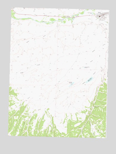
Hayden, CO USGS Topographic Map
Click on map above to begin viewing in our Map Viewer.

This topographic map contains these locations and features:
Feature Name Type Latitude Longitude GNIS ID View Map
Anderson Coal MineMineN40.4161°W107.2684°1683211View Map
Babson MineMineN40.4178°W107.2684°1683213View Map
Bearcat MineMineN40.4008°W107.2712°1683214View Map
Cary DitchCanalN40.4944°W107.3284°171357View Map
Cary GulchValleyN40.4957°W107.3462°171280View Map
Coryell MineMineN40.4169°W107.2684°1683215View Map
Crow Bar MineMineN40.4180°W107.2648°1683216View Map
Dill GulchValleyN40.4504°W107.2669°171379View Map
Dry CreekStreamN40.4908°W107.2795°171279View Map
Emrich ReservoirReservoirN40.4267°W107.2954°171361View Map
Grassy Creek Coal Company Mine Number OneMineN40.4647°W107.2684°1683212View Map
Greasewood Flat ReservoirReservoirN40.4435°W107.2803°171359View Map
HaydenPopulated PlaceN40.4953°W107.2573°201992View Map
Hayden Gulch Coal MineMineN40.4939°W107.2567°1683219View Map
Hayden Post OfficePost OfficeN40.4942°W107.2666°2750894View Map
Hubberson GulchValleyN40.3929°W107.2727°171364View Map
J C Temple Number 1 DamDamN40.4333°W107.2706°200012View Map
John C Temple Reservoir Number 1ReservoirN40.4315°W107.2727°171360View Map
John C Temple Reservoir Number 2ReservoirN40.4075°W107.2664°171358View Map
Lake Emrich DamDamN40.4283°W107.2939°200004View Map
Ramsay Number One MineMineN40.4161°W107.2659°1683217View Map
Sleepy Cat MineMineN40.3944°W107.2745°1683218View Map
Smuin GulchValleyN40.4853°W107.3127°171380View Map
Temple GulchValleyN40.4424°W107.2612°171362View Map
Watering Trough GulchValleyN40.3927°W107.2735°171363View Map
West Routt Fire Protection DistrictBuildingN40.4875°W107.2628°2667357View Map

Note: Coordinates in the location and feature list above are referenced to NAD83 datum.


Copyright (C) 2008-2024 Ryan Niemi / Sunset Dynamics ... All Rights Reserved