TopoQuest Logo
Do you find TopoQuest useful?
Help keep TopoQuest running and adding new maps/features by donating!
Bitcoin:  19c7KJd3qBynnjoSw5npx9KScwjBe4ifkT
Litecoin:  LXs6TkuXGGXo1vDsWCkWVdjQX94eUKd6ui
Home View Maps Find Maps Find Places Resources & Links


Oak Grove, Missouri Topographic Map

USGS Map Title: Oak Grove, MO
USGS Map MRC: 39094A2
DRG (GeoTIFF) Download: o39094a2.tif


Neighboring USGS Topographic Map Quads:


  Missouri City, MO  
39094B3
 

  Buckner, MO  
39094B2
 

  Camden, MO  
39094B1
 

  Blue Springs, MO  
39094A3
 

  Oak Grove, MO  
39094A2
 

  Bates City, MO  
39094A1
 

  Lake Jacomo, MO  
38094H3
 

  Tarsney Lakes, MO  
38094H2
 

  Chapel Hill, MO  
38094H1


Map MRC Location:

N40°
W95°
N40°
W94°
H8 H7 H6 H5 H4 H3 H2 H1
G8 G7 G6 G5 G4 G3 G2 G1
F8 F7 F6 F5 F4 F3 F2 F1
E8 E7 E6 E5 E4 E3 E2 E1
D8 D7 D6 D5 D4 D3 D2 D1
C8 C7 C6 C5 C4 C3 C2 C1
B8 B7 B6 B5 B4 B3 B2 B1
A8 A7 A6 A5 A4 A3 A2 A1
N39°
W95°
N39°
W94°

Oak Grove, MO USGS 1:24K Topographic Map Preview:
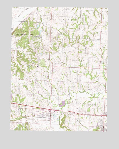
Oak Grove, MO USGS Topographic Map
Click on map above to begin viewing in our Map Viewer.

This topographic map contains these locations and features:
Feature Name Type Latitude Longitude GNIS ID View Map
Action GliderportAirportN39.0536°W94.2263°758590View Map
Assembly of God ChurchChurchN39.0803°W94.2199°713456View Map
Blue BranchStreamN39.0114°W94.1866°714397View Map
Bone HillSummitN39.1067°W94.1394°714517View Map
Bone Hill School (historical)SchoolN39.1064°W94.1263°734926View Map
Central Jackson County Fire Protection District Station 4BuildingN39.0109°W94.2082°2620440View Map
Chiddix CemeteryCemeteryN39.0794°W94.1922°715778View Map
City of Grain ValleyCivilN39.0166°W94.2086°2394945View Map
City of Oak GroveCivilN39.0074°W94.1278°2395283View Map
East Kansas City AirportAirportN39.0150°W94.2167°758700View Map
Elm Grove School (historical)SchoolN39.0164°W94.1611°734931View Map
Frick ParkParkN39.0028°W94.1374°718220View Map
Glenside School (historical)SchoolN39.0847°W94.1355°734927View Map
Grain ValleyPopulated PlaceN39.0150°W94.1986°718661View Map
Grain Valley CemeteryCemeteryN39.0264°W94.1880°718662View Map
Grain Valley Early Childhood CenterSchoolN39.0522°W94.2103°2744137View Map
Grain Valley High SchoolSchoolN39.0088°W94.2067°2545102View Map
Grain Valley North Middle SchoolSchoolN39.0528°W94.2090°2744136View Map
Grain Valley Police DepartmentBuildingN39.0188°W94.1976°2752126View Map
Grain Valley Post OfficePost OfficeN39.0163°W94.1989°2477762View Map
Green Chapel CemeteryCemeteryN39.0939°W94.1530°718786View Map
Harmon Lake DamDamN39.0650°W94.2269°762998View Map
HilerPopulated PlaceN39.0761°W94.1997°740269View Map
Hiler Post OfficePost OfficeN39.0761°W94.1997°759969View Map
Interchange 21CrossingN39.0275°W94.2492°2477633View Map
Interchange 24CrossingN39.0214°W94.1979°2477635View Map
Interchange 28CrossingN39.0161°W94.1286°2477637View Map
KKJC-AM (Blue Springs)TowerN39.0456°W94.2352°754268View Map
Lake City Army Ammunition PlantMilitaryN39.0965°W94.2479°2512257View Map
Levasy CemeteryCemeteryN39.1106°W94.1349°720927View Map
Matthews Elementary SchoolSchoolN39.0223°W94.1939°2545248View Map
Mecklin CemeteryCemeteryN39.0661°W94.1266°722190View Map
Mecklin School (historical)SchoolN39.0625°W94.1258°734929View Map
Mershon Lake DamDamN39.1017°W94.2119°762993View Map
Midwestern Christian AcademySchoolN39.0151°W94.1428°2545110View Map
Minter HillSummitN39.0025°W94.2272°722452View Map
Monkey MountainSummitN39.0058°W94.1819°722529View Map
Murphy School (historical)SchoolN39.0764°W94.1819°734928View Map
Number 77 LakeReservoirN39.1005°W94.2122°762994View Map
Number 78 DamDamN39.1067°W94.2152°762995View Map
Number 80 LakeReservoirN39.0641°W94.2260°762999View Map
Number 81 LakeReservoirN39.0778°W94.2113°763001View Map
Oak GrovePopulated PlaceN39.0050°W94.1294°735757View Map
Oak Grove Middle SchoolSchoolN39.0040°W94.1260°2545099View Map
Oakland CemeteryCemeteryN39.0794°W94.2205°723665View Map
Oakland School (historical)SchoolN39.0800°W94.2183°734923View Map
Pink HillPopulated PlaceN39.0503°W94.1972°734924View Map
Pink Hill ChurchChurchN39.0495°W94.1672°724409View Map
Pink Hill School (historical)SchoolN39.0497°W94.1733°734930View Map
Prairie Branch Elementary SchoolSchoolN39.0381°W94.2145°2545085View Map
Quickel Lake DamDamN39.0783°W94.2119°763000View Map
Saint Clair CemeteryCemeteryN39.0717°W94.1713°725740View Map
Sni - a - bar Elementary SchoolSchoolN39.0098°W94.2091°2545384View Map
Sunnynook School (historical)SchoolN39.1078°W94.1811°734925View Map
Swiney BranchStreamN39.0247°W94.1827°727392View Map
Tharp Orchard Lake DamDamN39.0950°W94.2186°763544View Map
Township of Sni-A-BarCivilN39.0309°W94.2183°766804View Map
Washburn Farm AirportAirportN39.0600°W94.1983°2679411View Map

Note: Coordinates in the location and feature list above are referenced to NAD83 datum.


Copyright (C) 2008-2024 Ryan Niemi / Sunset Dynamics ... All Rights Reserved