TopoQuest Logo
Do you find TopoQuest useful?
Help keep TopoQuest running and adding new maps/features by donating!
Bitcoin:  19c7KJd3qBynnjoSw5npx9KScwjBe4ifkT
Litecoin:  LXs6TkuXGGXo1vDsWCkWVdjQX94eUKd6ui
Home View Maps Find Maps Find Places Resources & Links


North Freedom, Wisconsin Topographic Map

USGS Map Title: North Freedom, WI
USGS Map MRC: 43089D7
DRG (GeoTIFF) Download: o43089d7.tif


Neighboring USGS Topographic Map Quads:


  Reedsburg East, WI  
43089E8
 

  Wisconsin Dells South, WI  
43089E7
 

  Lewiston, WI  
43089E6
 

  Rock Springs, WI  
43089D8
 

  North Freedom, WI  
43089D7
 

  Baraboo, WI  
43089D6
 

  Black Hawk, WI  
43089C8
 

  Sauk Prairie, WI  
43089C7
 

  Sauk City, WI  
43089C6


Map MRC Location:

N44°
W90°
N44°
W89°
H8 H7 H6 H5 H4 H3 H2 H1
G8 G7 G6 G5 G4 G3 G2 G1
F8 F7 F6 F5 F4 F3 F2 F1
E8 E7 E6 E5 E4 E3 E2 E1
D8 D7 D6 D5 D4 D3 D2 D1
C8 C7 C6 C5 C4 C3 C2 C1
B8 B7 B6 B5 B4 B3 B2 B1
A8 A7 A6 A5 A4 A3 A2 A1
N43°
W90°
N43°
W89°

North Freedom, WI USGS 1:24K Topographic Map Preview:
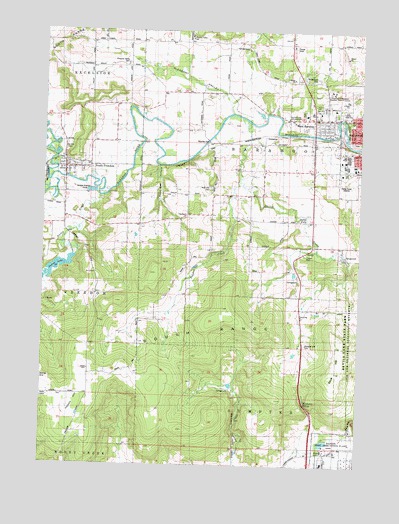
North Freedom, WI USGS Topographic Map
Click on map above to begin viewing in our Map Viewer.

This topographic map contains these locations and features:
Feature Name Type Latitude Longitude GNIS ID View Map
Attridge ParkParkN43.4703°W89.7568°1846795View Map
Baraboo High SchoolSchoolN43.4770°W89.7560°1846800View Map
Baraboo Hills Elementary SchoolSchoolN43.4648°W89.7722°2715849View Map
Baxter's Hollow State Natural AreaParkN43.4036°W89.8142°2081918View Map
Baxters HollowValleyN43.3752°W89.7972°1561316View Map
Bethel Memorial Baptist ChurchChurchN43.4755°W89.7548°1846806View Map
Black Hawk ManorPopulated PlaceN43.4583°W89.7589°2612462View Map
Brown Pit Number 1MineN43.4900°W89.7536°2711502View Map
Church of GodChurchN43.4714°W89.7612°1846816View Map
Fairview School (historical)SchoolN43.4472°W89.8187°1846828View Map
Happy HillSummitN43.3925°W89.8621°1566055View Map
Happy Hill School (historical)SchoolN43.4028°W89.8421°1846850View Map
Haskins ParkParkN43.4703°W89.7604°1846851View Map
Honey Boy Mobile Home ParkPopulated PlaceN43.4606°W89.7706°2612468View Map
Hoot Owl HollowValleyN43.4611°W89.8299°1566674View Map
Jack Young Middle SchoolSchoolN43.4805°W89.7559°1846802View Map
Kindschis SpringSpringN43.3942°W89.7712°1567491View Map
Mary Roundtree Evans Athletic FieldParkN43.4675°W89.7523°1846869View Map
McGilvra Woods State Natural AreaParkN43.4500°W89.8156°2081928View Map
Miller CemeteryCemeteryN43.3789°W89.7662°1569509View Map
North FreedomPopulated PlaceN43.4597°W89.8685°1570440View Map
North Freedom Elementary SchoolSchoolN43.4689°W89.8663°1846879View Map
North Freedom Fire DepartmentBuildingN43.4605°W89.8672°2697555View Map
Oak Hill CemeteryCemeteryN43.4666°W89.8679°1570644View Map
Ochsner ParkParkN43.4714°W89.7579°1570736View Map
Pewits Nest School (historical)SchoolN43.4530°W89.7885°1846890View Map
Pewits Nest State Natural AreaParkN43.4511°W89.7900°2082069View Map
Pine CreekStreamN43.4736°W89.7951°1571426View Map
Pine HollowValleyN43.3850°W89.7530°1571469View Map
Pleasant ValleyValleyN43.4766°W89.8014°1571638View Map
Pleasant Valley CemeteryCemeteryN43.4905°W89.8440°1571645View Map
Pleasant Valley SchoolSchoolN43.4972°W89.8193°1571656View Map
Rock Hill CemeteryCemeteryN43.4544°W89.8107°1572447View Map
Saint Michaels CemeteryCemeteryN43.4844°W89.7732°1573376View Map
Sauk County JailBuildingN43.4617°W89.7672°2759884View Map
Sauk County Sheriff's OfficeBuildingN43.4619°W89.7672°2759883View Map
Sauk HillSummitN43.4019°W89.7593°1573734View Map
Schraums DamDamN43.4367°W89.8618°1792026View Map
Seeley CreekStreamN43.4519°W89.8543°1573890View Map
Seeley LakeLakeN43.4320°W89.8684°1573891View Map
Seeley Lake 31ReservoirN43.4368°W89.8612°1792027View Map
Ski-Hi Fruit FarmLocaleN43.4225°W89.7614°2627659View Map
Skillet CreekStreamN43.4564°W89.7990°1574234View Map
Skillet Creek School (historical)SchoolN43.4383°W89.7696°1846949View Map
Skillet FallsFallsN43.4467°W89.7729°1574235View Map
South RangeRangeN43.4136°W89.7854°1574482View Map
Sumpter Hill CemeteryCemeteryN43.4097°W89.7712°1575069View Map
Thiessen FieldAirportN43.4178°W89.7654°1581874View Map
Town of BarabooCivilN43.4595°W89.7855°1582750View Map
University of Wisconsin Baraboo - Sauk County CenterSchoolN43.4816°W89.7657°1575933View Map
Village of North FreedomCivilN43.4590°W89.8604°1583828View Map
Village of West BarabooCivilN43.4814°W89.7718°1584398View Map
West BarabooPopulated PlaceN43.4744°W89.7704°1576445View Map
Willson Elementary SchoolSchoolN43.4777°W89.7607°1576832View Map
WRPQ-AM (Baraboo)TowerN43.4553°W89.7537°1582289View Map

Note: Coordinates in the location and feature list above are referenced to NAD83 datum.


Copyright (C) 2008-2024 Ryan Niemi / Sunset Dynamics ... All Rights Reserved