TopoQuest Logo
Do you find TopoQuest useful?
Help keep TopoQuest running and adding new maps/features by donating!
Bitcoin:  19c7KJd3qBynnjoSw5npx9KScwjBe4ifkT
Litecoin:  LXs6TkuXGGXo1vDsWCkWVdjQX94eUKd6ui
Home View Maps Find Maps Find Places Resources & Links


Newtonia, Mississippi Topographic Map

USGS Map Title: Newtonia, MS
USGS Map MRC: 31091A2
DRG (GeoTIFF) Download: o31091a2.tif


Neighboring USGS Topographic Map Quads:


  Laneheart, MS  
31091B3
 

  Wilkinson, MS  
31091B2
 

  Gloster, MS  
31091B1
 

  Woodville, MS  
31091A3
 

  Newtonia, MS  
31091A2
 

  Centreville, MS  
31091A1
 

  Laurel Hill, LA  
30091H3
 

  Rogillioville, LA  
30091H2
 

  Wilson, LA  
30091H1


Map MRC Location:

N32°
W92°
N32°
W91°
H8 H7 H6 H5 H4 H3 H2 H1
G8 G7 G6 G5 G4 G3 G2 G1
F8 F7 F6 F5 F4 F3 F2 F1
E8 E7 E6 E5 E4 E3 E2 E1
D8 D7 D6 D5 D4 D3 D2 D1
C8 C7 C6 C5 C4 C3 C2 C1
B8 B7 B6 B5 B4 B3 B2 B1
A8 A7 A6 A5 A4 A3 A2 A1
N31°
W92°
N31°
W91°

Newtonia, MS USGS 1:24K Topographic Map Preview:
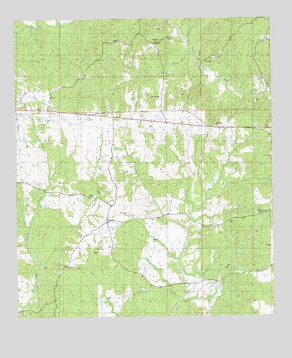
Newtonia, MS USGS Topographic Map
Click on map above to begin viewing in our Map Viewer.

This topographic map contains these locations and features:
Feature Name Type Latitude Longitude GNIS ID View Map
Bleak House ChurchChurchN31.0857°W91.2112°667268View Map
Cage ChapelChurchN31.0507°W91.2140°667905View Map
Carter CreekStreamN31.0380°W91.2443°668114View Map
Charlie Graves Lake DamDamN31.0102°W91.1884°680543View Map
Cory CemeteryCemeteryN31.1063°W91.1587°668844View Map
E M Kee Junior Lake DamDamN31.0818°W91.2284°680564View Map
Forest Home Airport (historical)AirportN31.0085°W91.2034°2676402View Map
Hatfield CemeteryCemeteryN31.0835°W91.1893°671008View Map
Hudson CemeteryCemeteryN31.1088°W91.2107°671556View Map
Huff CemeteryCemeteryN31.0788°W91.1843°671565View Map
Humphrey CemeteryCemeteryN31.1154°W91.1820°671579View Map
Jackson CemeteryCemeteryN31.1177°W91.1757°671770View Map
Jackson CreekStreamN31.1110°W91.1648°671774View Map
King CemeteryCemeteryN31.0393°W91.1468°672145View Map
Lake Walthall DamDamN31.0535°W91.1284°680557View Map
Matthews CreekStreamN31.0380°W91.1684°673243View Map
Mount PleasantPopulated PlaceN31.0788°W91.1501°692360View Map
Mount Pleasant ChurchChurchN31.0805°W91.1534°674220View Map
Netterville CemeteryCemeteryN31.1154°W91.2018°674560View Map
Newman CemeteryCemeteryN31.0921°W91.1793°690816View Map
Newman CemeteryCemeteryN31.0918°W91.1793°689796View Map
NewtoniaPopulated PlaceN31.0405°W91.2059°692107View Map
Phares CemeteryCemeteryN31.0438°W91.1993°675672View Map
Pilgrim Rest ChurchChurchN31.0407°W91.1434°675743View Map
Pine Grove ChurchChurchN31.0224°W91.2257°675820View Map
Pleasant Grove ChurchChurchN31.0377°W91.1265°675990View Map
Schuter CemeteryCemeteryN31.0666°W91.1254°690819View Map
Schuter CemeteryCemeteryN31.0660°W91.1257°689795View Map
Silver CreekStreamN31.1166°W91.1679°694786View Map
Supervisor District 1CivilN31.0402°W91.2326°712139View Map
Trinity ChurchChurchN31.0855°W91.2104°678881View Map
Wall CemeteryCemeteryN31.0452°W91.1309°679283View Map
Whitaker CemeteryCemeteryN31.0291°W91.1259°690608View Map
Whitaker CreekStreamN31.0182°W91.1696°679653View Map
White CemeteryCemeteryN31.1082°W91.1604°679573View Map
Whites ChurchChurchN31.1141°W91.1837°679636View Map

Note: Coordinates in the location and feature list above are referenced to NAD83 datum.


Copyright (C) 2008-2024 Ryan Niemi / Sunset Dynamics ... All Rights Reserved