TopoQuest Logo
Do you find TopoQuest useful?
Help keep TopoQuest running and adding new maps/features by donating!
Bitcoin:  19c7KJd3qBynnjoSw5npx9KScwjBe4ifkT
Litecoin:  LXs6TkuXGGXo1vDsWCkWVdjQX94eUKd6ui
Home View Maps Find Maps Find Places Resources & Links


New Market, Alabama Topographic Map

USGS Map Title: New Market, AL
USGS Map MRC: 34086H4
DRG (GeoTIFF) Download: o34086h4.tif


Neighboring USGS Topographic Map Quads:


  Lincoln, TN  
35086A5
 

  Flintville, TN  
35086A4
 

  Huntland, TN  
35086A3
 

  Fisk, AL  
34086H5
 

  New Market, AL  
34086H4
 

  King Cove, AL  
34086H3
 

  Meridianville, AL  
34086G5
 

  Maysville, AL  
34086G4
 

  Hollytree, AL  
34086G3


Map MRC Location:

N35°
W87°
N35°
W86°
H8 H7 H6 H5 H4 H3 H2 H1
G8 G7 G6 G5 G4 G3 G2 G1
F8 F7 F6 F5 F4 F3 F2 F1
E8 E7 E6 E5 E4 E3 E2 E1
D8 D7 D6 D5 D4 D3 D2 D1
C8 C7 C6 C5 C4 C3 C2 C1
B8 B7 B6 B5 B4 B3 B2 B1
A8 A7 A6 A5 A4 A3 A2 A1
N34°
W87°
N34°
W86°

New Market, AL USGS 1:24K Topographic Map Preview:
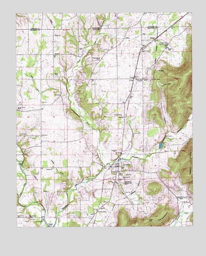
New Market, AL USGS Topographic Map
Click on map above to begin viewing in our Map Viewer.

This topographic map contains these locations and features:
Feature Name Type Latitude Longitude GNIS ID View Map
Antioch ChurchChurchN34.9868°W86.4730°113179View Map
B J FarmsLocaleN34.9778°W86.4672°2724539View Map
Baker CemeteryCemeteryN34.8915°W86.3755°113379View Map
Bethany BranchStreamN34.8981°W86.4580°113987View Map
Bethany ChurchChurchN34.9095°W86.4750°114003View Map
Bloucher FordCrossingN34.8754°W86.4755°156077View Map
Bloucher Ford CemeteryCemeteryN34.8812°W86.4997°114504View Map
Britton CemeteryCemeteryN34.9792°W86.4553°114929View Map
Brown FarmsLocaleN34.9525°W86.4986°2630414View Map
Camp MacobaLocaleN34.9431°W86.4458°146742View Map
Cedar GapGapN34.8784°W86.4067°115771View Map
Cedar Gap MountainSummitN34.8812°W86.3975°115772View Map
Clutches Fork (historical)LocaleN34.8806°W86.4797°146803View Map
Cochran CemeteryCemeteryN34.9051°W86.4230°116335View Map
Davis FarmsLocaleN34.9356°W86.4114°2630413View Map
FairviewPopulated PlaceN34.9759°W86.4736°156339View Map
Fairview Church (historical)ChurchN34.9754°W86.4733°1700428View Map
Fannings CrossingPopulated PlaceN34.8840°W86.4428°156342View Map
Flint River ChurchChurchN34.8787°W86.4814°118437View Map
Foster CemeteryCemeteryN34.9792°W86.4328°118534View Map
Fuqua SpringSpringN34.9612°W86.4029°118766View Map
Graveyard HillSummitN34.9181°W86.4305°119283View Map
Graveyard Hill CemeteryCemeteryN34.9167°W86.4278°157465View Map
Gravitt ChapelChurchN34.9398°W86.4253°119287View Map
Hambrick CemeteryCemeteryN34.8890°W86.3783°119616View Map
Hambrick CemeteryCemeteryN34.9295°W86.4125°119617View Map
Hayes ChapelChurchN34.9648°W86.4730°119885View Map
Hereford CemeteryCemeteryN34.9256°W86.3944°150055View Map
Hester CreekStreamN34.9103°W86.4372°120009View Map
Hickory Flat ChurchChurchN34.9609°W86.4105°120021View Map
Hickory Grove ChurchChurchN34.8918°W86.3850°120033View Map
HillsboroPopulated PlaceN34.9390°W86.4233°156476View Map
Hillsboro School (historical)SchoolN34.9398°W86.4250°1700429View Map
Hopewell ChurchChurchN34.9012°W86.4233°120386View Map
Jacks CemeteryCemeteryN34.8912°W86.4000°147013View Map
Jacks CemeteryCemeteryN34.8948°W86.4225°120753View Map
Jenny RiverStreamN34.9876°W86.4414°120855View Map
Jimmy Johnston LakeReservoirN34.8941°W86.4454°132058View Map
Jimmy Johnston Lake DamDamN34.8934°W86.4433°132059View Map
Jones CemeteryCemeteryN34.9223°W86.3953°120997View Map
Jones HollowValleyN34.9309°W86.3911°121022View Map
Landmark ChurchChurchN34.9354°W86.4425°147045View Map
Manning CemeteryCemeteryN34.9292°W86.4964°122256View Map
Miller CemeteryCemeteryN34.9679°W86.4036°122827View Map
Milner PondLakeN34.9796°W86.3925°122856View Map
Mint SpringPopulated PlaceN34.9518°W86.4680°156718View Map
Mint Spring School (historical)SchoolN34.9523°W86.4680°147115View Map
Mountain Fork ChurchChurchN34.9809°W86.3925°123511View Map
Mountain Fork Junior High SchoolSchoolN34.9006°W86.4239°123512View Map
Nance CemeteryCemeteryN34.8762°W86.3785°2129955View Map
Neeleys Chapel ChurchChurchN34.9126°W86.4472°147143View Map
New MarketPopulated PlaceN34.9101°W86.4278°155175View Map
New Market Census Designated PlaceCensusN34.8892°W86.4226°2403332View Map
New Market ChurchChurchN34.9070°W86.4108°147147View Map
New Market Middle SchoolSchoolN34.8926°W86.4250°147148View Map
New Market Post OfficePost OfficeN34.9103°W86.4272°166721View Map
New Market Presbyterian ChurchChurchN34.9104°W86.4294°1699970View Map
New Market United Methodist ChurchChurchN34.9073°W86.4269°1699971View Map
New Market Volunteer Fire Department Station 1BuildingN34.9061°W86.4281°2683031View Map
New Market Volunteer Fire Department Station 2BuildingN34.9618°W86.4154°2682862View Map
New Market Volunteer Fire Department Station 3BuildingN34.8758°W86.3918°2683409View Map
Norris CemeteryCemeteryN34.9054°W86.4255°123979View Map
Oakley ChurchChurchN34.9823°W86.3933°124155View Map
Payne BranchStreamN34.8812°W86.4719°1700444View Map
Petty CemeteryCemeteryN34.8954°W86.4783°124663View Map
Pleasant Grove Baptist ChurchChurchN34.9729°W86.4408°150002View Map
Pleasant Grove CemeteryCemeteryN34.9726°W86.4411°157498View Map
PlevnaPopulated PlaceN34.9618°W86.4167°125066View Map
Plevna ChurchChurchN34.9618°W86.4505°147206View Map
Plevna Elementary SchoolSchoolN34.9612°W86.4094°125067View Map
Plevna School (historical)SchoolN34.9615°W86.4278°1700433View Map
Prater SpringSpringN34.9657°W86.3997°125243View Map
Rice CemeteryCemeteryN34.8884°W86.4383°125593View Map
Rice ChurchChurchN34.8829°W86.4447°153141View Map
Rodgers BranchStreamN34.9006°W86.4517°153208View Map
RoseboroPopulated PlaceN34.9843°W86.4025°156995View Map
Saint Pauls ChurchChurchN34.9037°W86.4242°126191View Map
Seals FarmLocaleN34.9936°W86.4536°2724564View Map
Sharon Johnson ParkParkN34.8945°W86.4430°147259View Map
State Line CemeteryCemeteryN34.9909°W86.3797°157510View Map
State Line ChurchChurchN34.9909°W86.3792°147284View Map
Steele CemeteryCemeteryN34.9798°W86.4086°127342View Map
Steele CrossingPopulated PlaceN34.9781°W86.4105°157109View Map
Summers HollowValleyN34.9562°W86.3967°127541View Map
Swamp BranchStreamN34.9506°W86.4630°153616View Map
Taylor CemeteryCemeteryN34.9479°W86.4822°127733View Map
Underwood FarmLocaleN34.9964°W86.4947°2724566View Map
Union GrovePopulated PlaceN34.9284°W86.4825°157187View Map
Union Grove ChurchChurchN34.9248°W86.4822°147328View Map
Union Grove ChurchChurchN34.9276°W86.4828°1700436View Map
Walker BranchStreamN34.9693°W86.4564°147350View Map
Walnut GrovePopulated PlaceN34.9426°W86.4958°147354View Map
Walnut Grove Middle SchoolSchoolN34.9437°W86.4992°165569View Map
Whitman CemeteryCemeteryN34.9023°W86.4278°128926View Map
Zion Progress ChurchChurchN34.8809°W86.4914°129355View Map

Note: Coordinates in the location and feature list above are referenced to NAD83 datum.


Copyright (C) 2008-2024 Ryan Niemi / Sunset Dynamics ... All Rights Reserved