TopoQuest Logo
Do you find TopoQuest useful?
Help keep TopoQuest running and adding new maps/features by donating!
Bitcoin:  19c7KJd3qBynnjoSw5npx9KScwjBe4ifkT
Litecoin:  LXs6TkuXGGXo1vDsWCkWVdjQX94eUKd6ui
Home View Maps Find Maps Find Places Resources & Links


Belle Meade, Florida Topographic Map

USGS Map Title: Belle Meade, FL
USGS Map MRC: 26081A6
DRG (GeoTIFF) Download: o26081a6.tif


Neighboring USGS Topographic Map Quads:


  Naples North, FL  
26081B7
 

  Belle Meade NW, FL  
26081B6
 

  Belle Meade NE, FL  
26081B5
 

  Naples South, FL  
26081A7
 

  Belle Meade, FL  
26081A6
 

  Belle Meade SE, FL  
26081A5


  Marco Island, FL  
25081H6


Map MRC Location:

N27°
W82°
N27°
W81°
H8 H7 H6 H5 H4 H3 H2 H1
G8 G7 G6 G5 G4 G3 G2 G1
F8 F7 F6 F5 F4 F3 F2 F1
E8 E7 E6 E5 E4 E3 E2 E1
D8 D7 D6 D5 D4 D3 D2 D1
C8 C7 C6 C5 C4 C3 C2 C1
B8 B7 B6 B5 B4 B3 B2 B1
A8 A7 A6 A5 A4 A3 A2 A1
N26°
W82°
N26°
W81°

Belle Meade, FL USGS 1:24K Topographic Map Preview:
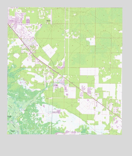
Belle Meade, FL USGS Topographic Map
Click on map above to begin viewing in our Map Viewer.

This topographic map contains these locations and features:
Feature Name Type Latitude Longitude GNIS ID View Map
Belle MeadePopulated PlaceN26.0498°W81.6995°278448View Map
Bickford Trailer ParkPopulated PlaceN26.0530°W81.6966°2450947View Map
Cannon IslandIslandN26.0018°W81.7495°307694View Map
Collier County Emergency Medical Services Station 21BuildingN26.0908°W81.7323°2661820View Map
Collier County Emergency Medical Services Station 23BuildingN26.0462°W81.7006°2661763View Map
Collier County Public Library East Naples BranchBuildingN26.0993°W81.7395°2450894View Map
Collier County Sheriff's Office District 3 East Naples SubstationBuildingN26.1053°W81.6947°2333642View Map
East Naples Fire Control and Rescue District Station 21BuildingN26.0908°W81.7321°2131695View Map
East Naples Fire Control and Rescue District Station 23BuildingN26.0462°W81.7006°2131697View Map
Edison State College - Collier CampusSchoolN26.1028°W81.7001°2548625View Map
Enchanting Shores Mobile Home ParkPopulated PlaceN26.0487°W81.6877°2450958View Map
Hall BayBayN26.0198°W81.7375°307706View Map
Henderson CreekGutN26.0370°W81.7193°283894View Map
Iverson Trailer ParkPopulated PlaceN26.0532°W81.6962°2450950View Map
Johnson BayBayN26.0017°W81.7372°284859View Map
Kenyon Mobile Home ParkPopulated PlaceN26.0531°W81.6939°2450951View Map
LelyPopulated PlaceN26.1006°W81.7284°1867168View Map
Lely Census Designated PlaceCensusN26.1032°W81.7297°2403229View Map
Lely High SchoolSchoolN26.0880°W81.7178°297388View Map
Lely ResortPopulated PlaceN26.0809°W81.6979°1853266View Map
Lely Resort Census Designated PlaceCensusN26.0890°W81.7032°2403230View Map
M and E Trailer ParkPopulated PlaceN26.0531°W81.6958°2450952View Map
Marco Island AirportAirportN26.0004°W81.6747°309645View Map
Marco Shores Estates Mobile Home ParkPopulated PlaceN26.0486°W81.6848°2450961View Map
Miccosukee Golf and Country Club Marlin Golf CourseLocaleN26.0322°W81.6944°2450907View Map
Miona Lake Golf ClubLocaleN26.0584°W81.7084°2450910View Map
Mustang Golf CourseLocaleN26.1050°W81.7378°2450916View Map
Naples ManorPopulated PlaceN26.0887°W81.7262°287530View Map
Naples Manor Census Designated PlaceCensusN26.0892°W81.7254°2403324View Map
Oakwood Golf ClubLocaleN26.0929°W81.7018°2450923View Map
Ocala Palms Golf and Country ClubLocaleN26.0965°W81.7002°2450925View Map
Old Marco JunctionPopulated PlaceN26.0229°W81.7006°288100View Map
Orange Park Country ClubLocaleN26.1046°W81.7386°2450932View Map
Orangebrook Country ClubLocaleN26.1150°W81.7226°2450934View Map
Oriole Golf and Tennis Club of MargateLocaleN26.0371°W81.6998°2450935View Map
Pelican Lake Motorcoach ResortPopulated PlaceN26.0339°W81.6944°2450954View Map
Physicians Regional Medical Center - Collier BoulevardHospitalN26.1053°W81.6850°2662523View Map
Rattlesnake HammockIslandN26.1112°W81.7068°289488View Map
Shell IslandPopulated PlaceN26.0243°W81.7326°295620View Map
Shell IslandIslandN26.0254°W81.7359°307680View Map
South Collier County Regional Wastewater Treatment FacilityLocaleN26.0959°W81.7260°2450890View Map
The Willough at NaplesHospitalN26.0962°W81.7363°2662508View Map
The WoodsIslandN26.0026°W81.7165°297331View Map
Umbrella IslandIslandN26.0026°W81.7437°297332View Map
Verona Walk Census Designated PlaceCensusN26.0839°W81.6794°2583385View Map
WBPT-FM (Naples)TowerN26.1229°W81.7226°309078View Map
WGUF-FM (Marco)TowerN26.0309°W81.6423°309052View Map
Whites RiverStreamN26.0093°W81.7368°307662View Map
Wing South AirparkAirportN26.1166°W81.7029°309710View Map
WRGI-FM (Naples)TowerN26.1229°W81.7226°309076View Map

Note: Coordinates in the location and feature list above are referenced to NAD83 datum.


Copyright (C) 2008-2024 Ryan Niemi / Sunset Dynamics ... All Rights Reserved