TopoQuest Logo
Do you find TopoQuest useful?
Help keep TopoQuest running and adding new maps/features by donating!
Bitcoin:  19c7KJd3qBynnjoSw5npx9KScwjBe4ifkT
Litecoin:  LXs6TkuXGGXo1vDsWCkWVdjQX94eUKd6ui
Home View Maps Find Maps Find Places Resources & Links


Naples South, Florida Topographic Map

USGS Map Title: Naples South, FL
USGS Map MRC: 26081A7
DRG (GeoTIFF) Download: o26081a7.tif


Neighboring USGS Topographic Map Quads:


  Naples North, FL  
26081B7
 

  Belle Meade NW, FL  
26081B6


  Naples South, FL  
26081A7
 

  Belle Meade, FL  
26081A6


  Marco Island, FL  
25081H6


Map MRC Location:

N27°
W82°
N27°
W81°
H8 H7 H6 H5 H4 H3 H2 H1
G8 G7 G6 G5 G4 G3 G2 G1
F8 F7 F6 F5 F4 F3 F2 F1
E8 E7 E6 E5 E4 E3 E2 E1
D8 D7 D6 D5 D4 D3 D2 D1
C8 C7 C6 C5 C4 C3 C2 C1
B8 B7 B6 B5 B4 B3 B2 B1
A8 A7 A6 A5 A4 A3 A2 A1
N26°
W82°
N26°
W81°

Naples South, FL USGS 1:24K Topographic Map Preview:
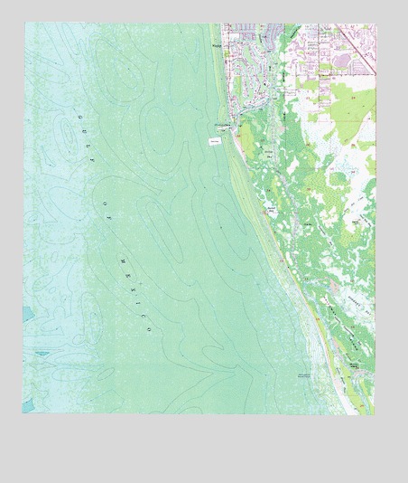
Naples South, FL USGS Topographic Map
Click on map above to begin viewing in our Map Viewer.

This topographic map contains these locations and features:
Feature Name Type Latitude Longitude GNIS ID View Map
Avalon Elementary SchoolSchoolN26.1083°W81.7651°297398View Map
Baptist Church of EsteroChurchN26.1031°W81.7845°302226View Map
Bartell BayBayN26.0672°W81.7877°307663View Map
Calhoun ChannelChannelN26.0020°W81.7520°300283View Map
Collier County Emergency Medical Services Station 22BuildingN26.1129°W81.7700°2661765View Map
Dollar BayBayN26.0894°W81.7866°281663View Map
East Naples Fire Department Control and Rescue District Station 22BuildingN26.1129°W81.7700°2131696View Map
Enchanting Acres Mobile Home ParkPopulated PlaceN26.1192°W81.7631°2450957View Map
Golden Gate United Methodist ChurchChurchN26.1170°W81.7693°301271View Map
Gordon PassBayN26.0974°W81.7941°294021View Map
Gulf Shores MarinaHarborN26.1214°W81.7710°2450942View Map
Haldeman CreekStreamN26.1156°W81.7862°297563View Map
Halloway IslandIslandN26.0415°W81.7729°307705View Map
Johns PassLocaleN26.0698°W81.7915°307704View Map
Keewaydin IslandIslandN26.0462°W81.7784°308480View Map
Kokomis FerryLocaleN26.0943°W81.7990°285173View Map
Lee Memorial United Methodist ChurchChurchN26.1143°W81.7568°301264View Map
Little Marco IslandIslandN26.0076°W81.7581°304982View Map
Little Marco PassChannelN26.0126°W81.7623°285737View Map
Monarch Country ClubLocaleN26.1249°W81.7580°2450912View Map
Munlin CreekBayN26.0174°W81.7576°307664View Map
Munlin IslandIslandN26.0162°W81.7581°307668View Map
Naples BayBayN26.1220°W81.7923°287529View Map
Nature Conservancy BayLakeN26.0248°W81.7578°297333View Map
New Pass (historical)ChannelN26.0734°W81.7926°307667View Map
Oak Tree Country ClubLocaleN26.1184°W81.7520°2450922View Map
Ocean Hammock Golf ClubLocaleN26.1248°W81.7580°2450926View Map
Periwinkle BayBayN26.0605°W81.7699°307665View Map
Port RoyalPopulated PlaceN26.1109°W81.7931°298993View Map
Rookery BayBayN26.0313°W81.7504°289939View Map
Rookery ChannelBayN26.0424°W81.7711°307691View Map
Royal HarborPopulated PlaceN26.1054°W81.7898°298994View Map
Sand HillSummitN26.0629°W81.7562°307669View Map
Sand Hill BayBayN26.0618°W81.7523°307683View Map
Sand Hill CreekStreamN26.0420°W81.7581°307670View Map
Seagate Baptist ChurchChurchN26.0990°W81.7831°301278View Map
Shell BayBayN26.0602°W81.7743°307679View Map
Southpointe MarinaHarborN26.1047°W81.7815°2450945View Map
Stopper CreekStreamN26.0426°W81.7518°307666View Map
The First NationalBayN26.0468°W81.7643°307699View Map

Note: Coordinates in the location and feature list above are referenced to NAD83 datum.


Copyright (C) 2008-2024 Ryan Niemi / Sunset Dynamics ... All Rights Reserved