TopoQuest Logo
Do you find TopoQuest useful?
Help keep TopoQuest running and adding new maps/features by donating!
Bitcoin:  19c7KJd3qBynnjoSw5npx9KScwjBe4ifkT
Litecoin:  LXs6TkuXGGXo1vDsWCkWVdjQX94eUKd6ui
Home View Maps Find Maps Find Places Resources & Links


Netarts, Oregon Topographic Map

USGS Map Title: Netarts, OR
USGS Map MRC: 45123D8
DRG (GeoTIFF) Download: o45123d8.tif


Neighboring USGS Topographic Map Quads:


  Garibaldi, OR  
45123E8
 

  Kilchis River, OR  
45123E7


  Netarts, OR  
45123D8
 

  Tillamook, OR  
45123D7


  Sand Lake, OR  
45123C8
 

  Beaver, OR  
45123C7


Map MRC Location:

N46°
W124°
N46°
W123°
H8 H7 H6 H5 H4 H3 H2 H1
G8 G7 G6 G5 G4 G3 G2 G1
F8 F7 F6 F5 F4 F3 F2 F1
E8 E7 E6 E5 E4 E3 E2 E1
D8 D7 D6 D5 D4 D3 D2 D1
C8 C7 C6 C5 C4 C3 C2 C1
B8 B7 B6 B5 B4 B3 B2 B1
A8 A7 A6 A5 A4 A3 A2 A1
N45°
W124°
N45°
W123°

Netarts, OR USGS 1:24K Topographic Map Preview:
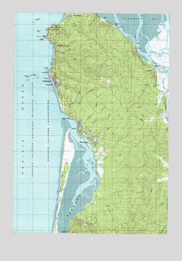
Netarts, OR USGS Topographic Map
Click on map above to begin viewing in our Map Viewer.

This topographic map contains these locations and features:
Feature Name Type Latitude Longitude GNIS ID View Map
Agate BeachBeachN45.4659°W123.9746°1135119View Map
Austin CreekStreamN45.3873°W123.9443°1154420View Map
B B DairyLocaleN45.4372°W123.8767°2707124View Map
Baughman CreekStreamN45.4570°W123.9687°1135116View Map
Big Barn RV Park and MarinaHarborN45.4547°W123.8755°2668224View Map
Big Barn RV Park and Marina Boat LaunchLocaleN45.4548°W123.8756°2668574View Map
Boulder PointCapeN45.4923°W123.9176°1138487View Map
Cape MearesCapeN45.4859°W123.9746°1139351View Map
Cape MearesPopulated PlaceN45.4898°W123.9587°1139352View Map
Cape Meares LighthouseBuildingN45.4864°W123.9781°1135118View Map
Cape Meares National Wildlife RefugeParkN45.4890°W123.9678°1155502View Map
Cape Meares Post Office (historical)Post OfficeN45.4898°W123.9587°1165011View Map
Cape Meares State Scenic ViewpointParkN45.4859°W123.9743°1139353View Map
Delta IslandIslandN45.4776°W123.8901°1158978View Map
Dick PointCapeN45.4812°W123.9024°1141016View Map
Dick Point DikeLeveeN45.4873°W123.9040°1135307View Map
Dry Stocking IslandIslandN45.4687°W123.8818°1135122View Map
Esther CreekStreamN45.4557°W123.8785°1141901View Map
Fagan CreekStreamN45.4387°W123.8957°1154411View Map
Fall CreekStreamN45.4418°W123.9571°1141973View Map
Flower Pot (historical)PillarN45.4968°W123.9310°1142264View Map
Flower Pot CreekStreamN45.4970°W123.9304°1154413View Map
Happy CampLocaleN45.4409°W123.9549°1143274View Map
Happy Camp County ParkParkN45.4401°W123.9549°1987704View Map
Hodgdon CreekStreamN45.4365°W123.9504°1135121View Map
Larson CreekStreamN45.4776°W123.9693°1154412View Map
Maxwell PointCapeN45.4629°W123.9724°1145890View Map
McCoys CoveBayN45.4945°W123.9201°1145950View Map
Memaloose CreekStreamN45.4693°W123.8873°1154416View Map
Memaloose PointCapeN45.4712°W123.8896°1146093View Map
Memaloose Point County Boat LaunchLocaleN45.4715°W123.8910°2668192View Map
NetartsPopulated PlaceN45.4348°W123.9460°1146792View Map
Netarts - Oceanside Rural Fire Protection District Station 61 HeadquartersBuildingN45.4367°W123.9480°2576979View Map
Netarts - Oceanside Rural Fire Protection District Station 62BuildingN45.4603°W123.9692°2576657View Map
Netarts - Oceanside Sanitary DistrictLocaleN45.4560°W123.9665°2660729View Map
Netarts BayBayN45.4050°W123.9489°1146793View Map
Netarts Census Designated PlaceCensusN45.4356°W123.9344°2408916View Map
Netarts Community County ParkParkN45.4298°W123.9410°1987786View Map
Netarts Landing County Boat LaunchLocaleN45.4304°W123.9462°2668569View Map
Netarts Post OfficePost OfficeN45.4348°W123.9460°1165698View Map
Netarts SpitBarN45.4082°W123.9596°1154419View Map
North Branch Fall CreekStreamN45.4470°W123.9512°1154418View Map
O'Hara CreekStreamN45.4309°W123.9460°1158399View Map
OceansidePopulated PlaceN45.4609°W123.9679°1147137View Map
Oceanside Beach State Recreation SiteParkN45.4609°W123.9710°1135117View Map
Oceanside Census Designated PlaceCensusN45.4549°W123.9613°2408975View Map
Oceanside Post OfficePost OfficeN45.4601°W123.9695°1165731View Map
Pillar RockIslandN45.4898°W123.9799°1147670View Map
Pyramid RockIslandN45.4959°W123.9840°1148069View Map
Rice CreekStreamN45.4268°W123.9385°1148416View Map
Rock PointCapeN45.4829°W123.9037°1148618View Map
Sand IslandIslandN45.4665°W123.8790°1135308View Map
Seal RockIslandN45.4637°W123.9846°1154414View Map
Short BeachBeachN45.4748°W123.9685°1149423View Map
Short CreekStreamN45.4726°W123.9699°1149432View Map
Silver SandsAreaN45.4304°W123.9457°1135309View Map
Snag IslandIslandN45.4698°W123.8798°1135123View Map
Spring Valley FarmsLocaleN45.4139°W123.8756°2707160View Map
Symons State ParkParkN45.4545°W123.9668°1940278View Map
Three Arch RocksIslandN45.4640°W123.9879°1151145View Map
Three Arch Rocks National Wildlife RefugeParkN45.4645°W123.9847°1155505View Map
Three Arch Rocks WildernessReserveN45.4623°W123.9852°2035323View Map
Tillamook RiverStreamN45.4876°W123.9018°1151222View Map
Tomlinson CreekStreamN45.4554°W123.8818°1154417View Map
Tomlinson SloughStreamN45.4662°W123.8821°1151326View Map
Trask RiverStreamN45.4704°W123.8826°1151402View Map
Whiskey CreekStreamN45.3948°W123.9360°1152187View Map
Wilson BeachBeachN45.4282°W123.9379°1152448View Map
Wilson RiverStreamN45.4790°W123.8901°1163358View Map
Yager CreekStreamN45.4145°W123.9337°1152686View Map

Note: Coordinates in the location and feature list above are referenced to NAD83 datum.


Copyright (C) 2008-2024 Ryan Niemi / Sunset Dynamics ... All Rights Reserved