TopoQuest Logo
Do you find TopoQuest useful?
Help keep TopoQuest running and adding new maps/features by donating!
Bitcoin:  19c7KJd3qBynnjoSw5npx9KScwjBe4ifkT
Litecoin:  LXs6TkuXGGXo1vDsWCkWVdjQX94eUKd6ui
Home View Maps Find Maps Find Places Resources & Links


Mudville, Louisiana Topographic Map

USGS Map Title: Mudville, LA
USGS Map MRC: 31092F4
DRG (GeoTIFF) Download: o31092f4.tif


Neighboring USGS Topographic Map Quads:


  Packton, LA  
31092G5
 

  Georgetown, LA  
31092G4
 

  Tullos, LA  
31092G3
 

  Williana, LA  
31092F5
 

  Mudville, LA  
31092F4
 

  Little Creek, LA  
31092F3
 

  Dry Prong, LA  
31092E5
 

  Pollock, LA  
31092E4
 

  Fishville, LA  
31092E3


Map MRC Location:

N32°
W93°
N32°
W92°
H8 H7 H6 H5 H4 H3 H2 H1
G8 G7 G6 G5 G4 G3 G2 G1
F8 F7 F6 F5 F4 F3 F2 F1
E8 E7 E6 E5 E4 E3 E2 E1
D8 D7 D6 D5 D4 D3 D2 D1
C8 C7 C6 C5 C4 C3 C2 C1
B8 B7 B6 B5 B4 B3 B2 B1
A8 A7 A6 A5 A4 A3 A2 A1
N31°
W93°
N31°
W92°

Mudville, LA USGS 1:24K Topographic Map Preview:
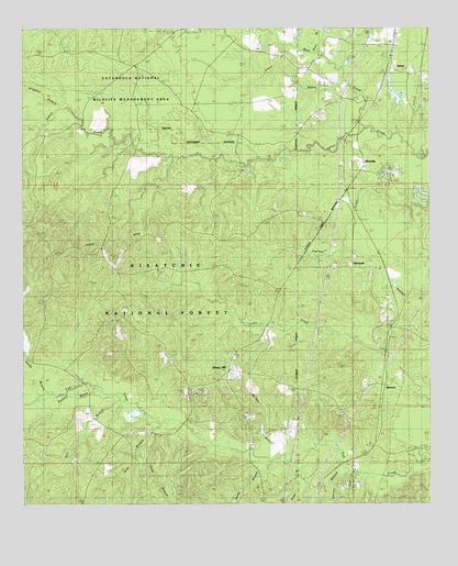
Mudville, LA USGS Topographic Map
Click on map above to begin viewing in our Map Viewer.

This topographic map contains these locations and features:
Feature Name Type Latitude Longitude GNIS ID View Map
Alligator BranchStreamN31.7296°W92.4876°546970View Map
Andalusia Church (historical)ChurchN31.7463°W92.4351°545741View Map
Bear CreekStreamN31.7232°W92.3921°547035View Map
Breezy HillPopulated PlaceN31.6605°W92.4368°547123View Map
Camp HardtnerPopulated PlaceN31.6313°W92.3993°547174View Map
Carson BranchStreamN31.6341°W92.3999°547194View Map
Clear BranchStreamN31.6452°W92.4582°547221View Map
Cross BayouStreamN31.7221°W92.3976°547266View Map
Cypress CreekStreamN31.7043°W92.3763°547281View Map
Devils BrakeSwampN31.6463°W92.3807°547298View Map
Gray BranchStreamN31.6477°W92.4568°547416View Map
Gray CemeteryCemeteryN31.6460°W92.4629°545773View Map
HowcottPopulated PlaceN31.6563°W92.3890°547484View Map
Jesse BranchStreamN31.6368°W92.4101°547523View Map
Johns HillsSummitN31.6916°W92.4851°547524View Map
Kees BranchStreamN31.7427°W92.4090°547537View Map
LincecumPopulated PlaceN31.6874°W92.3926°547588View Map
Louisiana Noname Number 56 DamDamN31.6302°W92.3985°556903View Map
McKay BranchStreamN31.6382°W92.4207°555274View Map
McKay CemeteryCemeteryN31.6446°W92.4176°547668View Map
Mill BranchStreamN31.6532°W92.4701°547700View Map
MudvillePopulated PlaceN31.7129°W92.3963°547765View Map
Panther BayouStreamN31.6557°W92.4757°547812View Map
Pine Knot CemeteryCemeteryN31.7388°W92.4637°555660View Map
Sandy BranchStreamN31.6366°W92.4185°547960View Map
Sandy BranchStreamN31.6557°W92.4857°547961View Map
SelmaPopulated PlaceN31.7413°W92.3871°547983View Map
Selma Oil FieldOilfieldN31.7168°W92.3932°545807View Map

Note: Coordinates in the location and feature list above are referenced to NAD83 datum.


Copyright (C) 2008-2024 Ryan Niemi / Sunset Dynamics ... All Rights Reserved