TopoQuest Logo
Do you find TopoQuest useful?
Help keep TopoQuest running and adding new maps/features by donating!
Bitcoin:  19c7KJd3qBynnjoSw5npx9KScwjBe4ifkT
Litecoin:  LXs6TkuXGGXo1vDsWCkWVdjQX94eUKd6ui
Home View Maps Find Maps Find Places Resources & Links


Mount Holly, North Carolina Topographic Map

USGS Map Title: Mount Holly, NC
USGS Map MRC: 35081C1
DRG (GeoTIFF) Download: o35081c1.tif


Neighboring USGS Topographic Map Quads:


  Lincolnton East, NC  
35081D2
 

  Lowesville, NC  
35081D1
 

  Lake Norman South, NC  
35080D8
 

  Gastonia North, NC  
35081C2
 

  Mount Holly, NC  
35081C1
 

  Mountain Island Lake, NC  
35080C8
 

  Gastonia South, NC  
35081B2
 

  Belmont, NC  
35081B1
 

  Charlotte West, NC  
35080B8


Map MRC Location:

N36°
W82°
N36°
W81°
H8 H7 H6 H5 H4 H3 H2 H1
G8 G7 G6 G5 G4 G3 G2 G1
F8 F7 F6 F5 F4 F3 F2 F1
E8 E7 E6 E5 E4 E3 E2 E1
D8 D7 D6 D5 D4 D3 D2 D1
C8 C7 C6 C5 C4 C3 C2 C1
B8 B7 B6 B5 B4 B3 B2 B1
A8 A7 A6 A5 A4 A3 A2 A1
N35°
W82°
N35°
W81°

Mount Holly, NC USGS 1:24K Topographic Map Preview:
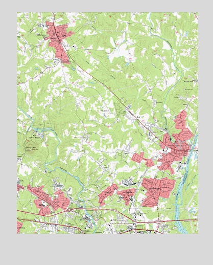
Mount Holly, NC USGS Topographic Map
Click on map above to begin viewing in our Map Viewer.

This topographic map contains these locations and features:
Feature Name Type Latitude Longitude GNIS ID View Map
Abbey PlazaLocaleN35.2532°W81.0290°1001599View Map
Aldersgate ChurchChurchN35.3076°W81.0320°980085View Map
Aviary GardensCemeteryN35.2582°W81.0817°980387View Map
Beech BrookPopulated PlaceN35.2596°W81.0645°1001602View Map
Belmont Abbey CemeteryCemeteryN35.2633°W81.0400°2779096View Map
Belmont Abbey CollegeSchoolN35.2543°W81.0434°980967View Map
Belmont Drive-InLocaleN35.2567°W81.0583°2559668View Map
Belmont JunctionLocaleN35.2826°W81.0365°1001604View Map
Berea ChurchChurchN35.2876°W81.0651°981030View Map
Berea Church CemeteryCemeteryN35.2882°W81.0646°2779110View Map
Bethel ChurchChurchN35.3226°W81.0070°981129View Map
Brown TownPopulated PlaceN35.2532°W81.0223°1019323View Map
Caldwell (historical)Populated PlaceN35.2865°W81.1009°1001609View Map
Carolinas Rehabilitation Center - Mount HollyBuildingN35.2631°W81.0300°2701546View Map
Catawba HeightsPopulated PlaceN35.2746°W81.0279°1019560View Map
Catawba Heights SchoolSchoolN35.2746°W81.0376°982750View Map
Cathey (historical)Populated PlaceN35.3118°W81.1101°1001611View Map
Christs Lutheran Church CemeteryCemeteryN35.3575°W81.0924°2779106View Map
City of LowellCivilN35.2692°W81.1013°2404966View Map
City of Mount HollyCivilN35.3115°W81.0100°2404319View Map
Collegetown Shopping CenterLocaleN35.2554°W81.0467°1001614View Map
Community Volunteer Fire DepartmentBuildingN35.2775°W81.0546°2638983View Map
Craig HeightsPopulated PlaceN35.3668°W81.0929°1001615View Map
Dutchmans CreekStreamN35.3004°W81.0031°984457View Map
East Gaston Senior High SchoolSchoolN35.3146°W81.0737°1001628View Map
East Gaston Volunteer Fire Department Station 30BuildingN35.3134°W81.0426°2638347View Map
East Lincoln Fire DepartmentBuildingN35.3049°W81.0209°2638456View Map
Eastwood VillageLocaleN35.2518°W81.0267°1001631View Map
Ebenezer Church CemeteryCemeteryN35.2656°W81.0391°2779097View Map
Edgewood CemeteryCemeteryN35.2701°W81.1004°984633View Map
Faith ChurchChurchN35.2760°W81.0681°984947View Map
Fites CreekStreamN35.2788°W81.0126°985125View Map
Goshen GrovePopulated PlaceN35.2757°W81.0554°1020479View Map
Green Meadows Country ClubLocaleN35.3196°W81.0612°986067View Map
Hickory Grove CemeteryCemeteryN35.3034°W81.0800°2779107View Map
Hickory Grove ChurchChurchN35.3043°W81.0801°986702View Map
Hillcrest CemeteryCemeteryN35.3222°W81.0472°986805View Map
Holbrook High SchoolSchoolN35.2660°W81.1065°986914View Map
Humphrey SchoolSchoolN35.2624°W81.1006°987242View Map
HutchinsonPopulated PlaceN35.2901°W81.0248°1001653View Map
Kiser SchoolSchoolN35.3618°W81.0917°988026View Map
Little Long CreekStreamN35.3079°W81.1206°988700View Map
Long CreekStreamN35.2790°W81.0087°988956View Map
Long CreekStreamN35.3110°W81.1151°988957View Map
LowellPopulated PlaceN35.2679°W81.1029°989086View Map
Lowell Elementary SchoolSchoolN35.2804°W81.0915°1001661View Map
Lowell Post OfficePost OfficeN35.2653°W81.0999°2773817View Map
Lowell Volunteer Fire DepartmentBuildingN35.2655°W81.1005°2638958View Map
Lucia - Riverbend Volunteer Fire DepartmentBuildingN35.3732°W81.0009°2639036View Map
Martin Pond Number TwoReservoirN35.2635°W81.0065°998695View Map
Martin Pond Number Two DamDamN35.2635°W81.0065°998696View Map
Mauney CemeteryCemeteryN35.3610°W81.1221°989480View Map
McAdenvillePopulated PlaceN35.2593°W81.0754°1021377View Map
McAdenville Elementary SchoolSchoolN35.2532°W81.0770°1001662View Map
McAdenville JunctionLocaleN35.2660°W81.0792°1001663View Map
McAdenville LakeReservoirN35.2618°W81.0765°998690View Map
McAdenville Lake DamDamN35.2618°W81.0765°998689View Map
McAdenville Post OfficePost OfficeN35.2586°W81.0767°2773868View Map
McAdenville Volunteer Fire DepartmentBuildingN35.2575°W81.0764°2639041View Map
Morningside CemeteryCemeteryN35.3318°W81.0092°990257View Map
Mount HollyPopulated PlaceN35.2982°W81.0159°990413View Map
Mount Holly CemeteryCemeteryN35.2957°W81.0224°2779109View Map
Mount Holly Fire and Rescue HeadquartersBuildingN35.3049°W81.0131°2639682View Map
Mount Holly Fire and Rescue Station 2BuildingN35.2750°W81.0277°2638203View Map
Mount Holly Police DepartmentBuildingN35.2964°W81.0106°2769817View Map
Mount Holly Post OfficePost OfficeN35.3046°W81.0321°2773932View Map
Murphy HeightsPopulated PlaceN35.3710°W81.1040°1001666View Map
New Providence ChurchChurchN35.3243°W81.0295°991081View Map
NimsPopulated PlaceN35.3096°W81.0304°1021649View Map
North BelmontPopulated PlaceN35.2724°W81.0481°991195View Map
North Belmont Elementary SchoolSchoolN35.2721°W81.0465°1001668View Map
O'Conners Grove ChurchChurchN35.2543°W81.0437°991338View Map
Oakland ChurchChurchN35.2760°W81.1101°991474View Map
Pineview CemeteryCemeteryN35.2926°W81.0301°2779108View Map
Queen of the Apostles ChurchChurchN35.2510°W81.0437°992940View Map
R E Rankin LakeReservoirN35.3435°W81.0281°998849View Map
R E Rankin Lake DamDamN35.3435°W81.0281°998848View Map
Rankin Elementary SchoolSchoolN35.2979°W81.0226°1001679View Map
Ridgeview ChurchChurchN35.2960°W81.0506°993343View Map
Rowland Lake Dam Number OneDamN35.3418°W81.1148°998842View Map
Rowland Lake Number OneReservoirN35.3426°W81.1143°998843View Map
Sharon ChurchChurchN35.2768°W81.0648°994584View Map
Sodyeco LagoonReservoirN35.2885°W81.0065°998751View Map
Sodyeco Lagoon DamDamN35.2885°W81.0065°998752View Map
South Stanley CreekStreamN35.3190°W81.0259°995216View Map
Spencer MountainPopulated PlaceN35.3062°W81.1106°1022733View Map
Spencer MountainSummitN35.2971°W81.1154°1022734View Map
Springfield Memorial ChurchChurchN35.3471°W81.0948°995368View Map
Springfield Memorial Church CemeteryCemeteryN35.3464°W81.0943°2779105View Map
Springfield SchoolSchoolN35.3482°W81.0967°995370View Map
SpringwoodPopulated PlaceN35.2726°W81.0629°1022759View Map
StanleyPopulated PlaceN35.3590°W81.0970°995408View Map
Stanley Civil Defense Rescue SquadBuildingN35.3511°W81.0942°2720406View Map
Stanley CreekStreamN35.3257°W81.0226°995412View Map
Stanley Junior High SchoolSchoolN35.3671°W81.1040°1001684View Map
Stanley ParkParkN35.3637°W81.0901°1001685View Map
Stanley Police DepartmentBuildingN35.3574°W81.0949°2769693View Map
Stanley Post OfficePost OfficeN35.3562°W81.0883°2773843View Map
Stanley Volunteer Fire DepartmentBuildingN35.3678°W81.0969°2638653View Map
Stowe Memorial ChapelChurchN35.2510°W81.0540°995596View Map
Taylor HeightsPopulated PlaceN35.3640°W81.1040°1001686View Map
Taylors CreekStreamN35.3079°W81.0206°995902View Map
Town of McAdenvilleCivilN35.2652°W81.0804°2406120View Map
Town of Spencer MountainCivilN35.3073°W81.1101°2407382View Map
Town of StanleyCivilN35.3552°W81.0937°2406656View Map
Township of RiverbendCivilN35.3495°W81.0390°1026700View Map
True Light ChurchChurchN35.3274°W81.0120°996274View Map
WBCY-FM (Charlotte)TowerN35.2974°W81.1145°1018258View Map
WBTV-TV (Charlotte)TowerN35.2974°W81.1145°1018586View Map
WCGC-AM (Belmont)TowerN35.2515°W81.0570°1018417View Map
Wesleyan ChurchChurchN35.2538°W81.0245°996975View Map
West CramertonPopulated PlaceN35.2526°W81.0879°1023163View Map
Woodland (historical)Populated PlaceN35.3179°W81.0456°1001696View Map
Woodlawn ChurchChurchN35.2771°W81.0987°997595View Map

Note: Coordinates in the location and feature list above are referenced to NAD83 datum.


Copyright (C) 2008-2024 Ryan Niemi / Sunset Dynamics ... All Rights Reserved