TopoQuest Logo
Do you find TopoQuest useful?
Help keep TopoQuest running and adding new maps/features by donating!
Bitcoin:  19c7KJd3qBynnjoSw5npx9KScwjBe4ifkT
Litecoin:  LXs6TkuXGGXo1vDsWCkWVdjQX94eUKd6ui
Home View Maps Find Maps Find Places Resources & Links


Lincolnton East, North Carolina Topographic Map

USGS Map Title: Lincolnton East, NC
USGS Map MRC: 35081D2
DRG (GeoTIFF) Download: o35081d2.tif


Neighboring USGS Topographic Map Quads:


  Reepsville, NC  
35081E3
 

  Maiden, NC  
35081E2
 

  Denver, NC  
35081E1
 

  Lincolnton West, NC  
35081D3
 

  Lincolnton East, NC  
35081D2
 

  Lowesville, NC  
35081D1
 

  Bessemer City, NC  
35081C3
 

  Gastonia North, NC  
35081C2
 

  Mount Holly, NC  
35081C1


Map MRC Location:

N36°
W82°
N36°
W81°
H8 H7 H6 H5 H4 H3 H2 H1
G8 G7 G6 G5 G4 G3 G2 G1
F8 F7 F6 F5 F4 F3 F2 F1
E8 E7 E6 E5 E4 E3 E2 E1
D8 D7 D6 D5 D4 D3 D2 D1
C8 C7 C6 C5 C4 C3 C2 C1
B8 B7 B6 B5 B4 B3 B2 B1
A8 A7 A6 A5 A4 A3 A2 A1
N35°
W82°
N35°
W81°

Lincolnton East, NC USGS 1:24K Topographic Map Preview:
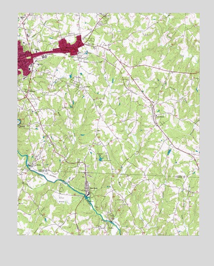
Lincolnton East, NC USGS Topographic Map
Click on map above to begin viewing in our Map Viewer.

This topographic map contains these locations and features:
Feature Name Type Latitude Longitude GNIS ID View Map
Asbury ChurchChurchN35.4821°W81.1876°980302View Map
Asbury Church CemeteryCemeteryN35.4832°W81.1869°2779082View Map
Asbury Elementary SchoolSchoolN35.4774°W81.2084°1024802View Map
Beals ChapelChurchN35.4824°W81.2017°1000727View Map
Beaverdam CreekStreamN35.4060°W81.2292°980849View Map
Boger CityPopulated PlaceN35.4807°W81.2134°1023370View Map
Boger City Baptist ChurchChurchN35.4793°W81.2198°1007767View Map
Boger City Fire DepartmentBuildingN35.4877°W81.2016°2638115View Map
Boger City First Will Baptist ChurchChurchN35.4854°W81.2195°1007766View Map
Boger City United Methodist ChurchChurchN35.4785°W81.2148°1007764View Map
Carolinas Medical Center - LincolnHospitalN35.4898°W81.2037°1024877View Map
Carpenters LakeReservoirN35.4182°W81.1927°982672View Map
Carpenters Lake DamDamN35.4171°W81.1934°998953View Map
Central Junior High SchoolSchoolN35.4785°W81.2373°982964View Map
City Memorial GardensCemeteryN35.4949°W81.1925°2779081View Map
City of High ShoalsCivilN35.3957°W81.2047°2405829View Map
City of LincolntonCivilN35.4746°W81.2385°2404933View Map
Covenant Bible ChurchChurchN35.4413°W81.2362°2571129View Map
Dallas LakeReservoirN35.3801°W81.1915°998900View Map
Dallas Lake DamDamN35.3801°W81.1915°998901View Map
David Memorial ChurchChurchN35.4579°W81.2054°983972View Map
David Memorial Church CemeteryCemeteryN35.4582°W81.2052°2779085View Map
Fancy Hill ChurchChurchN35.3926°W81.1770°984999View Map
First Assembly of GodChurchN35.4782°W81.2309°1007765View Map
Four Square Gospel ChurchChurchN35.4693°W81.2481°1007771View Map
Gallagher Trails Golf and Swim ClubLocaleN35.3960°W81.2198°1001638View Map
GoodsonvillePopulated PlaceN35.4804°W81.2062°1001778View Map
HardinsPopulated PlaceN35.3793°W81.1904°986395View Map
Harvest ChurchChurchN35.4662°W81.2248°2681555View Map
Herndon ChurchChurchN35.4562°W81.2445°986647View Map
High ShoalsPopulated PlaceN35.4026°W81.2023°986765View Map
High Shoals Elementary SchoolSchoolN35.4043°W81.2017°1001650View Map
High Shoals LakeReservoirN35.3968°W81.2065°998928View Map
High Shoals Lake DamDamN35.3968°W81.2065°998929View Map
High Shoals Post OfficePost OfficeN35.4088°W81.2026°2773892View Map
High Shoals Volunteer Fire DepartmentBuildingN35.4013°W81.2011°2639058View Map
Hollybrook CemeteryCemeteryN35.4804°W81.2456°986965View Map
Holy Cross ChurchChurchN35.4896°W81.1992°1000755View Map
Indian CreekStreamN35.4212°W81.2492°987352View Map
Iron StationPopulated PlaceN35.4415°W81.1562°987400View Map
Iron Station Census Designated PlaceCensusN35.4515°W81.1568°2628638View Map
Iron Station Elementary SchoolSchoolN35.4429°W81.1551°1001780View Map
Iron Station Post OfficePost OfficeN35.4447°W81.1563°2774013View Map
Lick RunStreamN35.4818°W81.1462°988458View Map
Lincoln Correctional CenterBuildingN35.4836°W81.2356°2769872View Map
Lincoln Country ClubLocaleN35.4618°W81.2212°1007762View Map
Lincoln CountyCivilN35.4856°W81.2235°1008569View Map
Lincoln County Emergency Medical ServicesBuildingN35.4887°W81.2385°2720512View Map
Lincoln County Health CenterBuildingN35.4921°W81.2470°1007774View Map
Lincoln County Sheriff's OfficeBuildingN35.4892°W81.2376°2769805View Map
Lincolnton PlazaLocaleN35.4974°W81.2492°1007773View Map
Lincolnton Police DepartmentBuildingN35.4743°W81.2484°2769715View Map
Lincolnton-Lincoln County Regional AirportAirportN35.4844°W81.1626°1001782View Map
Lithia SpringsPopulated PlaceN35.4585°W81.2267°1001785View Map
Long ShoalsPopulated PlaceN35.4149°W81.2404°989010View Map
Long Shoals LakeReservoirN35.4135°W81.2431°998950View Map
Long Shoals Lake DamDamN35.4135°W81.2431°998951View Map
Midland Shopping CenterLocaleN35.4782°W81.2329°1007763View Map
Miller SidingLocaleN35.4771°W81.2031°1001786View Map
Moores Chapel CemeteryCemeteryN35.4788°W81.2396°2779086View Map
Mount Olive ChurchChurchN35.4760°W81.2442°1007768View Map
Mount Vernon ChurchChurchN35.4626°W81.1737°990598View Map
Mount Vernon Church CemeteryCemeteryN35.4626°W81.1736°2779083View Map
Muddy CreekStreamN35.4062°W81.2204°990753View Map
Ore Bank BranchStreamN35.4990°W81.1467°991682View Map
Pearl ChurchChurchN35.4501°W81.1567°991991View Map
Pearl Church CemeteryCemeteryN35.4504°W81.1557°2779084View Map
Pentecostal Apostle Church of Jesus ChristChurchN35.4729°W81.2420°1007772View Map
Pisgah Church CemeteryCemeteryN35.4300°W81.2296°2779091View Map
Providence Baptist ChurchChurchN35.4776°W81.2456°1007769View Map
Rattle Shoal CreekStreamN35.3785°W81.1804°993043View Map
Ruth Memorial ChurchChurchN35.3946°W81.1767°993825View Map
S Ray Lowder Elementary SchoolSchoolN35.4632°W81.2454°1024836View Map
Sailors BranchStreamN35.3801°W81.1548°993855View Map
Saint Pauls ChurchChurchN35.3799°W81.1929°994082View Map
SalemPopulated PlaceN35.4340°W81.1954°1022465View Map
Salem CemeteryCemeteryN35.4330°W81.1948°2779092View Map
Sharon ChurchChurchN35.4671°W81.1442°994587View Map
South Fork Volunteer Fire DepartmentBuildingN35.4250°W81.2324°2638458View Map
South LincolntonPopulated PlaceN35.4543°W81.2437°995174View Map
SouthsidePopulated PlaceN35.4368°W81.2459°1022724View Map
Southside ChurchChurchN35.4449°W81.2395°1000787View Map
Sulphur BranchStreamN35.3976°W81.2040°995677View Map
Temple Baptist ChurchChurchN35.4701°W81.2459°1007770View Map
Township of IrontonCivilN35.4797°W81.1462°1026888View Map
Township of LincolntonCivilN35.4882°W81.2481°1026889View Map
Victory Grove ChurchChurchN35.4543°W81.2315°1000795View Map
Wayside ChurchChurchN35.4987°W81.2084°996895View Map

Note: Coordinates in the location and feature list above are referenced to NAD83 datum.


Copyright (C) 2008-2024 Ryan Niemi / Sunset Dynamics ... All Rights Reserved